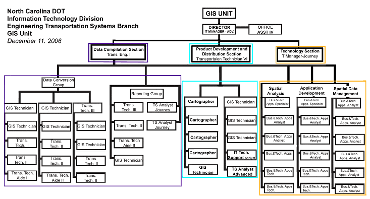
Figure 6: Organizational chart for the Information Technology Division of the North Carolina GIS Unit
(adapted from organizational chart received from NCDOT).
CONTACT: L.C. SMITH, GIS DIRECTOR, (919) 212-6001
LCSMITH@DOT.STATE.NC.US
The initial motivation for creating a GIS program at the North Carolina Department of Transportation (NCDOT) was to address a need for producing planning maps cost-effectively. For this reason, NCDOT's GIS activities originated in the Department's Transportation Planning Branch, formerly known as the Statewide Planning Branch. Early on, the Branch began an effort to spatially organize a database of roadway characteristics called the Universe file that NCDOT would maintain, and then to link the file to digital maps. As part of this major effort, NCDOT digitized the centerlines of state-maintained roads from manually produced Mylar maps. NCDOT staff then used U.S. Geological Survey (USGS) orthophotography to verify the accuracy of digitized data.
No specific person initiated this effort, but the managers of NCDOT's Statewide Planning Branch and the secretary of transportation were very supportive. In general, broad support for developing the geospatial infrastructure was available within NCDOT before any visible projects or applications emerged.
Today, the activities of NCDOT's GIS Unit have evolved to include the provision of a wide variety of GIS services to help meet the business goals of both NCDOT and its counterpart state agencies, such as the Department of Environment and Natural Resources. A variety of data, maps, tools, and information are available as downloads on the NCDOT Data Distribution Center website https://connect.ncdot.gov/resources/gis/Pages/GIS-Data-Layers.aspx.
The GIS Unit within NCDOT has been reorganized several times and currently resides within the Engineering Transportation Systems Branch of NCDOT's Information Technology Division. Within the GIS Unit, there are 56 staff positions distributed across three sections (Figure 6):

NCDOT recognizes that the types of positions involved in maintaining its GIS require information technology professionals, and many positions have IT-oriented job descriptions. Due to the complexity of managing and storing spatial data at NCDOT, even technicians who compile data obtained from engineers and planners to add to the spatial database require IT skills. To express the IT demands of working in the group, the GIS Unit has described itself as "a professional GIS office that relies heavily on information technology to achieve its goals."
NCDOT has been committed to ensuring that current and potential future staff have the skills necessary to work in the GIS Unit. For example, the GIS Unit offers NCDOT staff a one-day "Introduction to ArcGIS (ArcMap/ArcView) 9" class.12 Externally, the GIS Unit has worked with local universities, such as North Carolina State University, to hire students as part-time and intern staff. NCDOT has also encouraged North Carolina Central University's effort to apply for a grant to educate public school teachers about GIS activities.
Funding
The NCDOT GIS Unit is funded through a combination of state and federal funds (SPR funding). Unit heads or representatives in the IT Division meet every two weeks to review applications for new IT projects, including those submitted by the GIS Unit. These meetings allow knowledge and experience to be shared in the formulation of cost estimates, schedules, and requirements. The GIS Unit then submits proposals for funding from the Department's IT budget to NCDOT's chief information officer for approval. The more expensive IT projects must be reviewed by the Statewide Information Technology Office.13
NCDOT and the Statewide GIS Community
NCDOT freely shares its spatial data with state and local agencies in North Carolina. With the exception of data layers protected by provisions in state statutes, geospatial information is also freely shared with the public.
This openness is in part facilitated by the existence of the North Carolina Interagency Leadership Team (ILT), an important part of the statewide GIS community. The team, which first convened in 2004, comprises representatives from 10 federal and state agencies involved in transportation planning, economic development, cultural resource preservation and environmental decision-making processes. These agencies are:
The ILT has prepared a charter of goals and strategies. Its first goal is to develop a shared, comprehensive GIS. The group has recognized that making improvements to a GIS infrastructure shared across agencies is a "critical step toward more effective and efficient transportation planning".14 NCDOT is active within the ILT, as is the Department of Environment and Natural Resources, whose Center for Geographic Information and Analysis (CGIA) is considered the state's leading agency for GIS.
Another important GIS project at the state level is NC OneMap,15 an online application for viewing, searching, and downloading GIS data seamlessly across North Carolina. CGIA has been the leading group behind NC OneMap, and NCDOT's GIS Unit has worked very closely with CGIA through data sharing and support. NC OneMap feeds into the USGS National Map16 and is part of the evolving national spatial data infrastructure.
Work is ongoing to develop a system for assisting small local agencies that do not have the capability to upload their spatial data to a central repository such as NC OneMap. It is expected that such a system would help to expedite the planning process for local projects and the analysis of traffic incidents.
Reference