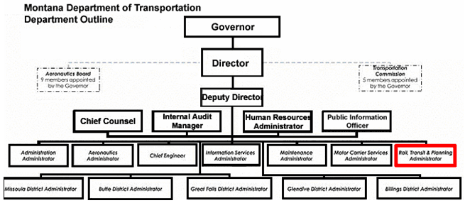
Figure 5: Organizational chart for the Montana Department of Transportation
(adapted from organizational chart from MDT)
CONTACT: BILL CLOUD, (406) 444-6114
MARLIN SANDER, (406) 444-9294
E-MAIL: bcloud@mt.gov
msander@mt.gov
The Montana Department of Transportation (MDT) first used geospatial technologies in 1994. Early on, there were little or no set criteria for gauging business needs within MDT's various divisions. For this reason, the Department's geospatial activities were primarily application-based; applications that were developed were often built in a somewhat ad hoc manner on the basis of perceived requirements of MDT division staff. Over time, it became apparent that these applications might not be in alignment with specific business needs.
Now, MDT is making a focused effort to develop a geospatial infrastructure and plan for a program that answers the question, "What do we need?" In doing so, MDT is establishing a more efficient, cost-effective, and user-friendly means for managing, maintaining, and monitoring the geospatial data underlying its business activities and decisions.
In January 2007, MDT released its GIS Strategic Plan. The Plan, produced by a consultant, sets forth a deliberate course of action for maximizing resources devoted to the management and maintenance of geospatial data. It provides a strategic direction for GIS investment while improving workflow in and among divisions. The Plan also examines how geospatial data and applications can be incorporated into planned and existing management systems, support new integrated initiatives, promote enterprise data management, and make information more accessible within MDT for better decision-making. The cost of fully implementing the GIS Strategic Plan is estimated to be $9 million if the majority of the work is outsourced.
GIS activities at MDT are managed by two divisions: the Rail, Transit and Planning Division and the Information Services Division (ISD) (Figure 5).

The Rail, Transit and Planning Division, which comprises the Data and Statistics Bureau, the Multimodal Planning Bureau, the Project Analysis Bureau, and the Program and Policy Analysis Bureau, provides a broad range of multimodal planning, program, and data collection and analysis functions. The Data and Statistics Bureau is responsible for collecting, processing, analyzing, and reporting general transportation infrastructure data for the state; it also performs a majority of the Department's statewide mapping activities and geospatial data distribution. Within the Data and Statistics Bureau, five staff positions are dedicated to GIS, three of which are GIS specialists.
The ISD also plays a role in the implementation of MDT's geospatial technology activities. The Division, which delivers IT support to MDT, develops a majority of the geospatial data standards for the Department. ISD also builds the geospatial applications that are ultimately used by the Rail, Transit and Planning Division and others.
While the ISD and the Rail, Transit, and Planning Division perform different work functions, the offices work together very closely. ISD performs infrastructure, spatial data management, applications development, training, security, and storage functions as well as the traditional GIS data integration. The Rail, Transit, and Planning Division performs infrastructure data collection, road log management, and mapping functions.
To enhance coordination regarding geospatial activities between these and other divisions within MDT, a GIS Steering Committee consisting of mid-level managers was developed. The committee first worked to help interpret MDT's business requirements (developed by an independent contractor through interviews with over 480 personnel) for incorporation in the GIS Strategic Plan. The committee initially met once a week, but later, as the project developed, it convened whenever its input was needed.
Historically, MDT has always had an executive-level advocate for GIS, and the GIS Steering Committee has helped to strengthen awareness among MDT executives as to how geospatial data can facilitate improved decision-making. Similarly, an IT board convenes at the state level to provide a forum to guide state agencies in the development, deployment, and advancement of intergovernmental IT resources. Established by Senate Bill 131, the board consists of all division and deputy administrators from Montana's state agencies. Board meetings are held in order to:
Data Consistency
At times, the management and distribution of geospatial data in Montana has been somewhat of a free-for-all. The DOA works to ensure that the state's IT infrastructure is reliable, secure, and cost-effective and that it meets the business requirements of state agencies and residents. It has also attempted to provide consistency by serving as a geospatial data clearinghouse. However, data standards have not always been enforced. The DOA manages three GIS layers that MDT uses, but information stored in these layers can originate from other agencies, potentially creating obstacles to analysis. For this reason, agencies in Montana have sometimes independently developed layers that, upon request, are supplied to MDT to store internally.
MDT is currently working with its state-agency counterparts to facilitate the development of data, security, and management standards.
Obstacles
Both the Rail, Transit and Planning Division and the ISD have faced challenges in bringing geospatial technologies into prevalence at MDT. The Rail, Transit and Planning Division is not organizationally structured in a way that makes it possible to know whether its efforts are being duplicated elsewhere in MDT. Thus, there has been a need, which is now being addressed through the GIS Strategic Plan, to cooperate and explicitly define who will be doing which activities.
The ISD has sometimes had issues with the funding of geospatial activities. Many of the ISD's projects are not as high-profile as those of the Rail, Transit and Planning Division; thus, little or no return-on-investment or cost-benefit analyses have been conducted. The GIS Strategic Plan will seek to address this deficit by including measures for assessing the costs and benefits of GIS applications across divisional boundaries.
Additionally, the ISD is tasked with responding to the varying needs of MDT divisions, such as planning, engineering, and maintenance. Since MDT's different divisions have variable and non-overlapping business requirements for the same transportation data (for example, the Linear Referencing System), it has sometimes been challenging for the ISD to develop cost-effective geospatial applications.