August 2018
A Newsletter from the Federal Highway Administration (FHWA)
www.gis.fhwa.dot.gov
A Grassroots Effort: MIT Mapathon aid to Puerto Rico post Hurricane Maria
Article by Lily Bui, PhD candidate at Massachusetts Institute of Technology
In the wake of Hurricane Maria in September, 2016, rather than donating money, students at MIT donated what they had: mapping skills. Lily Bui led the crowd-sourced mapping effort leveraging the Open Street Map platform. This article is based on an interview with Ms. Bui and is lightly edited for length and clarity.
Background
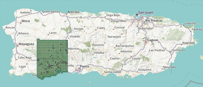
Figure 1: Map illustrating the focus-area of one mapathon
As the full extent of Hurricane Maria’s devastating hit to Puerto Rico was still being uncovered, multiple teams across the country kicked into high gear to aid in the recovery efforts. To assist in this work, the Red Cross and the Humanitarian OpenStreetMapping Team (HOT) collaborated to launch a campaign: they were going to crowdsource GIS (Geographic Information Systems) help in identifying every building that existed in Puerto Rico prior to the storm via satellite images and volunteers using GIS. Identifying and marking these buildings in OpenStreetMap would allow the Red Cross to better identify the hardest hit areas and estimate the response needed on a regional scale. Humanitarian OpenStreetMapping has used GIS in other disaster relief aid campaigns, and is currently running more campaigns focusing on malaria prevention and disaster response.
One of the local mapathons coordinated to aid in this effort took place at MIT, drawing over 40 community members from around the Boston region to the library for an evening of collaborative mapping. We spoke with Lily Bui, a PhD student in MIT’s Department of Urban Studies and Planning (DUSP) program and GIS instructor who was one of the initial organizers of the effort, about how the event unfolded and the future of the collaboration. The following has been edited for length and clarity.
The Beginning
Could you provide a brief overview of the project?
We organized an event with many volunteers to map out where buildings existed before Hurricane Maria hit Puerto Rico. The Red Cross was really interested in where buildings were to better estimate where aid should be targeted, and how much aid was needed. They were working on this campaign with many communities through the OpenStreetMapping platform. We heard news of the project through a colleague mentioning a New York Times article, “A Mapathon to Pinpoint Areas Hardest Hit in Puerto Rico,” and were interested in participating.
The impetus for us behind the project was to organize a way for students and others to provide aid to Puerto Rico that wasn’t donating material goods or money. We’ve been calling it ‘information aid.’ My specialization is disaster risk reduction, particularly on islands. After disasters, there is usually too little information, and then an explosion of information after the initial crisis. During our mapathon there was too little information on the impacts to Puerto Rico. Other groups at MIT were doing different things to aid Puerto Rico, but we were trying to organize within our group. On a Slack channel, someone mentioned a Mapathon at Columbia, and so we got in touch with them and got this template from them for it, so we could do it logistically. Two of my friends and I all happened to be GIS instructors at MIT in the DUSP program, and we had a new group of students interested in social justice and change, and enthusiastic about GIS. We got an overwhelming amount of support from them to show up, and got more support from the open mapping community in Boston.
The Mapathon
What happened on the day of the Mapathon?
We got about 40 people to show up over about 4 hours on a Sunday—it was great to get people coming from the other side of town and interacting with students! The Humanitarian OpenStreetMap Team and the Red Cross had opened one campaign with a series of maps of different parts of Puerto Rico. We trained users to look at satellite imagery that pre-dated the hurricane. Focusing on one region at a time, they would then dial in on one of the grid cells in that region and mark where buildings used to be before the hurricane hit.
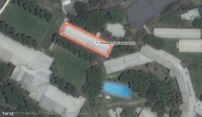
Figure 2: Sample image of what it looks like to edit an object in OpenStreetMap
While there are many sophisticated satellites to take pictures of damage, what the Red Cross and others needed was to know what the place looked like before the hurricane to decide how to distribute aid. On a call after the mapathon, the Red Cross said they were going to use these maps for deciding where to concentrate relief, and in the longer term recovery process over the coming months and years.
Forming the Team
Tell us about the process of organizing this, and how the current team was formed.
We organized the event by email, and just set up a time to meet. At the end of our lunch meeting with MIT library, we had the plan for the event. This is where Sophia comes in. Sophia Leung works for MIT library and couldn’t come to the first mapathon, but she heard about it and reached out to me to ask how we could work together to continue the effort. Sophia is in charge of an educational initiative to create events that bring communities of interest together around relevant issues around current events in the world. When we met up and she learned about the effort, she offered to organize a second and third mapathon at MIT, and now she’s really carrying the torch.
Future Work
What will this work look like going forward?
Sophia is thinking about her role and the library programming opportunities to follow up and help in future mapathons to respond to other disasters. I think the way she’s carrying this forward is the most sustainable effort that’s come out of this, and asks what the role of universities in the world is. Information aid is something that universities can provide, and have the capacity to organize meaningfully within their students to contribute without much cost. Students may not have much money, but have time and can contribute through volunteer efforts. Providing institutional support for this is an amazing role for Sophia; we all have full time school or work, but Sophia’s job involves producing programming for the library, so this was an especially wonderful partnership. While the maps for Puerto Rico are completely done and the mapathons were really effective, future mapathons may feature either slow onset disasters (like climate change) or for more recent disasters (like the recent earthquake in central Mexico).
Get Healthy with CMM
Editorial by Paul Giroux, Master of Science in GIS, GIS Professional
Paul Giroux has spent a career studying and using Capability Maturity Models (CMMs). In this editorial, Mr. Giroux makes the connection between “Enterprise GIS health” and personal health and the way in which we can track each.
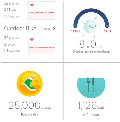
Figure 3: A Fitness tracker dashboard.
Just enough to gauge health and progress.
How many of you at some point decided to take steps to improve your overall health only to revert to old habits?
I know I have!
Like many of you, I recognize health is important and society does a great job reminding us of this. I’ve tried various methods to kick old habits. I found that if I measure my current health like BMI, use tools to track progress, and plan meals around clean eating, then I’m more apt to stick with it. And, from past experience, I recognized I simply couldn’t go from couch to Ultraman athlete.
My fitness tracker has a shared dashboard and online ecosystem that makes my health open and transparent. It makes me feel accountable knowing others are watching and often cheering progress. More importantly, if my family participates and supports my endeavor, it increases (but doesn’t guarantee) my chance of success. Unfortunately, I frequently find myself in couch mode—that’s my status quo, but I’ll get up and try again.
Your Enterprise GIS health is similar to personal health. You may already be working (or scrambling) to improve your program while sustaining what you already built. Is this your status quo—is your GIS health truly improving as a result of your efforts? Do you have a way to measure and track progress? Do you have a full stack team capable of working at an Enterprise level? What factors are you targeting to move the needle on initiatives and move closer to an Enterprise level of maturity? Can leadership distinguish the difference between traditional GIS for mapping and GIS as a mission critical enterprise business system?
My experience with maturity modeling as a means to measure GIS health grew from academic research and case study where I worked as a civil servant. I was struggling to get core data management efforts off the ground. Senior leadership buy-in wasn’t translating to any relevant business transformations. We had capacity but lacked an enterprise capability. Getting healthy by targeting ‘the Enterprise level’ was more difficult than I had ever imagined.
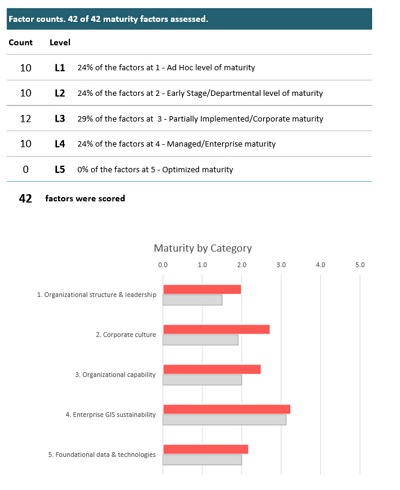
Figure 4: A section of the Slimgim maturity dashboard.
Just enough to gauge Enterprise GIS health and progress
Networking with peers revealed the issues I was experiencing were common across organizations. And so I dug in and developed the Slimgim Maturity Model and Framework as a tool to assess enterprise GIS health. This tool was purposefully built for enterprise geospatial professionals like yourself. I built it for speed and it needed to be pragmatic. To be useful, it needed to generate an Enterprise GIS Health Report similar to the fitness tracker dashboards I had used to track personal fitness targets and progress.
Recently, a new version of Slimgim CMM for Transportation was announced in the Fall 2017 FHWA GIS-T Newsletter. Through Peer Exchange and collaboration, this group made significant improvements to the base CMM on your behalf. Language has improved, redundant factors removed, and several factors merged. The result is a much cleaner, practical, and effective Slimgim for Federal and State Transportation. With this new tool, you’ll gain a clearer picture of your agency’s enterprise health and provide the information you need to design data-informed improvement initiatives. This, effectively, is your enterprise GIS health tracker!
As the Transportation CMM model rolls out, I encourage you to use the new tool to measure the health of your current GIS program. If you’re new to maturity modeling, I recommend the following schedule to kick off your enterprise health improvement effort:
- Week 1: Take 2 hours to complete your first assessment then set it aside.
- Week 2: Take 1 hour to fine tune your scores then review and digest the results and summary.
- Week 3: Take 2 hours to review the results tab again then design improvement initiatives.*
*Slimgim Tip: Design improvement initiatives by grouping factors that fit within a theme (Awareness, Competency, etc.). Select factors with a high likelihood to improve. Take a copy of your assessment and adjust the numbers to test your improvement scenario. This method will show how you can move the needle on your Enterprise GIS maturity. Adjust then implement your initiative.
With this small investment in time, I guarantee you’ll end up with an accurate picture of your agency’s Enterprise GIS maturity and capability by using the new Transportation CMM. More importantly, you’ll have the evidence needed to recruit others in the organization who will be required to improve your Enterprise GIS health with you, one step at a time.
If you work with GIS at a State DOT and are interested in piloting this new tool, email Mark Sarmiento at Mark.Sarmiento@dot.gov. For more information regarding Slimgim, or if you would like to know more about me, visit https://www.slimgim.info.
Other News
Upcoming Events
AMPO Annual Conference
The 2018 Association of Metropolitan Planning Organizations (AMPO) Annual Conference will be held in San Antonio on September 24-28. AMPO set up a room block for attendees. To reserve your room and register for the event, follow this link: http://www.ampo.org/news-events/2018-ampo-annual-conference/
Peer Exchange
The Federal Highway Administration (FHWA) and the Volpe Center are organizing a peer exchange on the topic of Data Governance. The peer exchange will be held in Little Rock, Arkansas on September 18 and 19, and representatives from 5 State DOTs will be participating.
New Reports Available
A report summarizing a peer exchange is now available. This peer exchange was hosted in September 2017 and focused on participant States’ experience using Capability Maturity Models (CMM), what their respective agencies would gain by completing a CMM, and developing a new draft CMM for State DOT use. It’s available here along with our other reports: www.gis.fhwa.dot.gov/reports.aspx.
Coming Soon
Case Study Report
A case study report on a new Capability Maturity Model assessment designed specifically for State DOTs is now avilable. FHWA and the Volpe Center asked 4 State DOTs and 1 Canadian Province to complete the new assessment. The results of that study can be found in a report on this page: www.gis.fhwa.dot.gov/reports.aspx.
Webcast Summary
In May 2018, Eric Abrams of Iowa DOT presented on the Slimgim Maturity Model and the development of the Slimgim-T model designed specifically for departments of transportation. A recording of that webcast and a written report are available here: www.gis.fhwa.dot.gov/webinars.aspx.
Peer Exchange Summary
A summary of a peer exchange organized by FHWA in Spring 2018 is now available. On April 10th and 11th, representatives from Alabama DOT, Georgia DOT, Maryland SHA, North Carolina DOT, and Pennsylvania DOT met in Harrisburg, PA for a peer exchange on using GIS for maintenance activities. The summary is available here: www.gis.fhwa.dot.gov/reports.aspx.
For more information about this newsletter, please contact Mark Sarmiento, FHWA Office of Planning, at Mark.Sarmiento@dot.gov.

