Webinar 34
Washington State Department of Transportation (WSDOT) Bridge Geospatial Location and Vertical Clearance Data Project
October 5, 2017
Summary of the Federal Highway Administration’s Quarterly Webinar: Applications of Geospatial Technologies in Transportation
Background
This webinar is one installment of the Applications of Geospatial Technologies in Transportation webinar series sponsored by the Federal Highway Administration (FHWA). The series highlights notable examples of geospatial information system (GIS) applications and efforts from transportation agencies from around the country. Each installment is on a topic that is of interest to the community and provides opportunity for transportation professionals to learn about how colleagues are applying GIS and spatial data in the world of transportation.
This presentation highlights an effort by Washington State DOT to make available to the public an online tool to display vertical clearance for overpasses across the state. Today’s presentation is made by Alan Smith (SmithA@wsdot.wa.gov), GIS & Roadway Data Branch Manager; Eric Jackson (JacksoE@wsdot.wa.gov), Systems Development Manager; and Rich Harper (HarperR@wsdot.wa.gov), Senior GIS Application Developer. Approximately 55 participants attended the webinar.
The presentation used in this webinar is available here for download.
Introduction
In May 2013, a vehicle struck an upper support structure of the Skagit Bridge in Burlington, Washington, triggering a National Transportation Safety Board (NTSB) review. While the strike was not related to erroneous data, NTSB recommended that providing more information to drivers would prove advantageous in preventing these types of accidents. The NTSB recommendation was the impetus for WSDOT to develop a robust GIS solution to overhead clearance operations, which the State DOT then made available to the public.
Creating the Application
The first response to the NTSB recommendations was to publish a simple table called a “Bridge List,” which listed all of the overpasses with their respective vertical clearance. WSDOT’s Bridge Preservation Office (BPO) then conducted a review of all overpasses under 16’6” and created “Clearance Cards” to support internal data collection.
Figure 1: Bridge Preservation Office “Clearance Card”
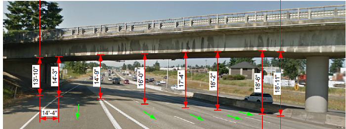
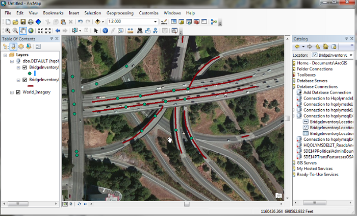
However, to fully support the NTSB recommendations, a true geospatial display of clearance height was necessary. To do so, WSDOT generated and stored geometry using existing Linear Referencing System (LRS) data to edit the location of bridges. WSDOT added location tables and clearance to the existing bridge database. A weekly extract pulls this information from the internal database to make it publically available via a web application programming interface (API).
Figure 2: WSDOT Bridge Inventory in ArcMap
WSDOT described some of the technical and business constraints experience when creating the application, such as funding and data availability limitations (e.g. State routes only, lacking local roads). Furthermore, the current version of the application only includes the minimum and maximum clearances for overpasses, not which lane or direction of travel from which those values come.
Next Version
To address the latter drawback—which lanes provide how much clearance—WSDOT is currently working to upgrade the Vertical Clearance application. The presenters provided a demonstration as to how they are accomplishing the data collection and entry for lane-specific clearances to be included in the database. This more robust dataset will be made available to the public via a web app created with input from the BPO, Washington Trucking Association members, and pilot car companies.
Results and Future Work
Since January 2016, when the first (and current) version of the application was made live, overall usage has grown from 900 visitors per month to 2,000 visitors per month. Building on this success, WSDOT is working on internal workflows that will alert staff when a Bridge Clearance Card is updated so they can update lane data in the database. The State DOT is also working to incorporate a number of features into the publically facing application such as live travel alerts and a basic routing functionality on State Routes.
Question and Answer Session
After the presentation, WSDOT opened the floor to questions from webinar participants. When asked about the frequency with which the agency can update the photos of the overpasses, WSDOT responded that the agency can cover half of the State in a year, and the whole State therefore gets updated biennially. Another participant asked about incorporating local agency data, since the demonstration only illustrated State-managed roadways. WSDOT responded that it is currently in discussions with the county road administrations of Washington counties. The agency has explored an interfacing system, but due to the patchwork of data from county to county, irregular update frequencies between counties, and data cleanliness issues, it is going to be a challenge. The agency has explored working with counties insofar as Highway Performance Management System (HPMS) and safety related issues, but nothing in the way of the vertical clearance application yet. Another question addressed WSDOT’s data entry workflow. While one person is responsible for inputting the data, the information is previously vetted by the BPO. Furthermore, the data in the database at large requires specific permissions tied to user logins to enter or edit. However, the system does not track edit-by-edit which user changed what data.
Conclusion
The first generation of the application has been successful enough to justify the continued investment to improve the application. To use the Bridge Vertical Clearance Trip Planner yourself, please visit the WSDOT website. The presenters expressed they will continue to be very open to questions and feedback; their contact information can be found in this summary and on the last slide of their presentation.


