Uses of Geospatial Applications for Transportation Performance Management Peer Exchange
Spokane, Washington
June 30-July 1, 2015
Host Agency
Spokane Regional Transportation Council

Participating Peer Agencies
City of Flagstaff
Flagstaff Metropolitan Planning Organization
Florida Department of Transportation
Michigan Department of Transportation
Oregon Department of Transportation
St. John's County Department of Public Works
Washington Department of Transportation
TABLE OF CONTENTS
ACKNOWLEDGMENTS
The U.S. Department of Transportation John A. Volpe National Transportation Systems Center (Volpe Center) in Cambridge, Massachusetts, prepared this report for the Federal Highway Administration's (FHWA) Office of Planning. The Volpe Center project team wishes to thank the participants in the peer exchange, which are listed in Appendix A, for providing their experiences, insights, and editorial review. The time they kindly provided was vital to preparing the exchange and reviewing this final report.
Back to Top
INTRODUCTION
Purpose
This report provides highlights from a peer exchange held in Spokane, Washington, on June 30-July 1, 2015. The exchange, which was held as part of FHWA's Geographic Information Systems (GIS) in Transportation program,1 focused on the topic of uses of geospatial/GIS tools and applications to support effective transportation performance management (TPM).
Background
TPM is a strategic approach that uses transportation system information to make investment and policy decisions to achieve national performance goals. TPM is a systematic, ongoing approach to transportation decision-making that involves:
- Identifying key information about the transportation system that allows decision-makers to better understand the consequences of their investment decisions;
- Improving communications between decision-makers, stakeholders, and the traveling public; and
- Ensuring that performance targets and measures are developed in cooperative partnerships and are based on data and objective information.
In recent years, transportation agencies have increasingly adopted data-driven management tools and performance management approaches to make more informed and effective investments in the transportation system. The Moving Ahead for Progress in the 21st Century Act (MAP-21) sought to formalize these processes and institute TPM as a core component of all surface transportation management, including but not limited to investment decision-making. MAP-21 outlines national performance goals relating to the National Highway Performance Program, the Highway Safety Improvement Program, the Congestion Mitigation and Air Quality Program, and freight movement. Through its Office of TPM, FHWA will issue final regulations on performance management for Federal-aid recipients, conduct training and education on the new regulations, and share best practices.2
FHWA considers TPM to be a comprehensive approach for managing the entire transportation system. However FHWA recognizes that TPM has links to other types of performance management approaches such as asset management, which focuses on managing physical assets based on their useful life and replacement requirements,3 and transportation performance-based planning and programming (PBPP). According to FHWA, PBPP shares many of TPM's core principles but focuses on incorporating performance goals specifically into the planning and programming phases of transportation decision-making.4 FHWA will issue final regulations for asset management and PBPP concurrent with the roll out of TPM regulations.
FHWA believes that geospatial/GIS tools and applications can support a wide range of performance management goals.5 However, there have been few opportunities for transportation agencies to share information on how geospatial/GIS tools and application can support TPM-specific goals (due in part to the fact that MAP-21 TPM rulemakings are still forthcoming). The GIS-TPM peer exchange sought to fill this gap by providing a forum for State departments of transportation (DOTs) and local transportation agencies to share noteworthy practices, success factors, and challenges encountered in using, developing, and maintaining geospatial/GIS applications and tools that support performance management approaches (e.g., asset management, PBPP, maintenance management) as well as TPM specifically.
FHWA's Office of Planning sponsored the peer exchange with support from FHWA's Office of TPM. The Spokane Regional Transportation Council (SRTC) hosted the event at its offices in Spokane. Participants included staff from SRTC as well as the City of Flagstaff (Arizona) and Flagstaff Metropolitan Planning Organization (MPO), Florida DOT (FDOT), Michigan DOT (MDOT), Oregon DOT (ODOT), St. John's County (Florida) Department of Public Works (DPW), and Washington DOT (WSDOT). See Appendix A for a complete participant list.
FHWA began the peer exchange by presenting an overview of FHWA's GIS in Transportation program, FHWA's definition of TPM, and a summary of national geospatial initiatives such as the Highway Performance Management System (HPMS), which requires States to submit data on various characteristics of State-owned public roads. The introductory session was followed by peer presentations and demonstrations of tools or applications. Peers also participated in a series of roundtable discussions throughout the exchange that addressed pre-identified topics of interest to both FHWA and the peers. The exchange concluded with a discussion of next steps and final remarks from FHWA that summarized recurring themes. See Appendix A for the peer exchange agenda, including roundtable discussion topics.
Overview of Peer Examples
The examples presented in the peer exchange focused on the use of geospatial/GIS tools and applications to support a range of performance management approaches, in particular asset management, PBPP, and maintenance activities. Given the forthcoming MAP-21 TPM rules, peers reported that they are still in the early stages of developing (or considering how to develop) geospatial/GIS tools that support TPM-specific goals as proposed by FHWA. However, peers anticipated that they could build upon existing initiatives and efforts to refine, tailor, or adopt current GIS tools for TPM-related goals over the next few years. Table 1 on the next page provides an overview of the examples highlighted during the peer exchange.
Table 1. Overview of Examples
| Agency Name |
Name of GIS Tool/
Application/Initiative
|
Overview of GIS Tool/Application/Initiative |
| City of Flagstaff and Flagstaff Area MPO |
- Establishing Performance Measures
|
The City and MPO are evaluating existing coverage of performance-related data for their areas with the goal of establishing measures to support evaluation of transportation system performance. |
| FDOT |
- Reliability of Freight Flows around Dedicated Freight Corridors
- Bicycle Level of Service (LOS)
|
FDOT is evaluating the viability of integrating a variety of data sources, such as the National Performance Management Research Data Set (NPMRDS) and bicycle safety data, for specific project-based analyses. FDOT's Transportation Analysis Office has found particular success in using performance data, imported into GIS, to perform project-based analyses and to investigate the value of recent investments. |
| MDOT |
- Performance-Based Maintenance (PBM) Framework
- Transportation Asset Management System (TAMS)
- Michigan Maintenance Rating System (MiMRS)
|
MDOT is developing a PBM framework that will provide an outcome focus for maintenance delivery. At the same time, it is initiating TAMS to support performance data integration and standardization across its seven operating Regions. It is also piloting the MiMRS to support the consistent assessment and reporting of performance measures and level of service. |
| ODOT |
- Features Attributes and Conditions Survey - Statewide Transportation Improvement Program (FACS-STIP)
- Data2Go
|
ODOT's FACS-STIP is an asset management database primarily designed for internal use that supports centralized data storage and oversight for highway asset management. ODOT integrated this tool with a customized add-on, Data2Go, which enables field staff to update asset condition information in FACS-STIP from virtually anywhere in the State. |
| SRTC |
|
SRTC's Horizon 2040, the region's long-range transportation plan, outlines guiding principles and key indicators that will be the focus of the agency's performance monitoring over the life of the plan. SRTC is developing a toolkit with geospatial elements to support data monitoring and performance management analysis. |
| St. John's County DPW |
|
Cityworks is a maintenance management system that integrates with DPW geospatial data. DPW uses Cityworks to support a variety of asset management activities as well as project tracking. |
| WSDOT |
- WSDOT Gray Notebook
- GIS to Support Performance Reporting/Asset Management
|
WSDOT's Gray Notebook is the agency's quarterly performance and accountability report. It also provides a comprehensive listing of all available transportation data within the State and identifies performance indicators for its districts. WSDOT is integrating these indicators into an enterprise GIS to streamline performance reporting and asset management. |
Back to Top
PEER EXCHANGE DISCUSSION HIGHLIGHTS
Discussions held during the exchange centered around four topics:
- Adapting current performance management geospatial/GIS tools and applications to support TPM goals;
- Establishing transportation system performance measures;
- Collecting and maintaining transportation system performance data (i.e., data stewardship); and
- Anticipated or expected benefits associated with using geospatial/GIS resources to support TPM goals.
More detail on each of these topics is provided below.
A. Adapting Performance Management Tools for TPM Goals
Most peers reported that their agencies currently use geospatial/GIS tools and applications to support performance management approaches. Some of the more advanced tools support automatic updates after project changes and provide the ability to track project implementation and costs. Peers suggested that these types of GIS tools could be adapted, tailored, or refined in various ways in the future to help evaluate transportation system performance as a whole.
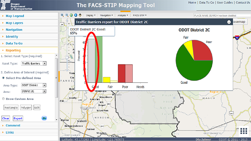
Figure 1. ODOT's FACS-STIP summary reporting feature for its District 2C.
- Peer example: ODOT launched its FACS-STIP tool in 2009 as a central repository to collect the agency's asset management information and data on projects included as part of the Statewide Transportation Improvement Program. An interdisciplinary ODOT team led development of the FACS-STIP to ensure that it met the needs of each office within ODOT. Since 2009, ODOT has made a series of updates and improvements to the FACS-STIP. For example, the tool now includes the ability to define asset update cycles based on asset type (e.g., bridges, pavements). The latest update of the FACS-STIP also provides for improved summary reporting capabilities to enable cities and counties, ODOT district offices, managers, and others to view asset condition and performance at a summary level, such as viewing what percentage of bridges in a district are in “fair” condition) (see Figure 1). These new capabilities may help ODOT adapt the FACS-STIP to address TPM-specific goals in the future.
-
Peer example: In 2006, St John's County DPW implemented a system called Cityworks, which integrates with DPW's ArcGIS Online (AGOL) data.6 Cityworks' primary function is to allow DPW staff to monitor the status of public works projects and condition of assets (e.g., traffic signs, culverts, pavement) via a centralized location. Cityworks also helps DPW staff track and geospatially locate work orders (see Figure 2). Recent updates to Cityworks have allowed the DPW to improve its pavement management practices with predictive modeling and targeted replacement scheduling based on the condition of surrounding assets. Updates have also improved reporting around Federal Emergency Management Association (FEMA) declared events by streamlining work order types based on FEMA categories for designated priority road networks—a key feature in a hurricane-prone area such as St. John's County.
Cityworks includes a series of dashboards and custom reporting features that make it easy for users to see, at one glance, an array of performance information including internal agency performance as well as overall system performance. For example, one internal productivity dashboard shows DPW's year to date activities (e.g., repaired potholes) and costs associated with these activities. Another dashboard shows information on the overall performance of various DPW assets such as traffic signals, culverts, and guard rails.
DPW noted that Cityworks has helped the organization move toward a performance-based budgeting approach, making it easier to justify where and how funds are being spent and allocate resources to achieve specific objectives. Cityworks has also provided DPW with a way to better estimate future asset management needs and resource allocations to help meet these needs. DPW believed that Cityworks provides robust data that the organization could share with others across the State, including the North Florida Transportation Planning Organization (the MPO for St. John's County and three other counties) or FDOT to help meet TPM-specific goals.
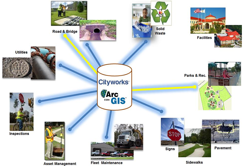
Figure 2. Conceptual framework for Cityworks.
B. Establishing System Performance Measures
Peers acknowledged that the core of a robust TPM program is a suite of measures to monitor overall system performance, safety, and asset condition from a holistic, multi-modal perspective. Establishing appropriate measures and reporting on progress against these measures will provide transportation agencies, the public, and others information with which to effectively evaluate performance, set targets for specific outcomes, identify investment priorities, and communicate the impacts of specific investments.
The peers represented a range of experience with establishing these types of cohesive system measures. Some peers reported developing initial or draft measures to assess transportation system reliability, congestion, safety, asset condition, transit performance, and maintenance needs. A number of peers expressed interest in developing measures to capture transportation system reliability from a multi-modal perspective. Most peers, however, noted that they are still identifying what data are available from which to craft these types of performance measures, as well as what staff and funding resources are available to engage in these efforts.
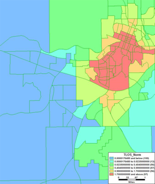
Figure 3. Flagstaff region transit LOS by traffic analysis zone (TAZ).
-
Peer Example: The Flagstaff MPO is working collaboratively with the City of Flagstaff to identify an array of transportation system performance measures that would benefit from GIS data analysis, such as annual hours of delay per capita, vehicle miles traveled (VMT) per capita, acres of natural/cultural resources disturbed by proposed transportation projects, and bicycle, pedestrian, and transit level of service (LOS). The MPO and City of Flagstaff already use GIS data to evaluate aspects of transportation performance; for example, the MPO uses GIS data to assess transit LOS, evaluate distribution of transit services, and estimate future demand for these services (Figure 3). While engaging in these types of discrete analyses, the MPO and City of Flagstaff are also exploring how geospatial/GIS tools can support more holistic, network-level performance analyses, such as assessing the reliability of the Flagstaff region's multi-modal transportation system rather than just transit LOS.
The MPO also noted that it currently has a GIS-based right-of-way (ROW) alignment tool to help visualize and track changes in transportation ROWs through different parts of the Flagstaff region. The MPO noted that this tool already helps the agency estimate and project costs associated with ROW changes; the tool may provide a model or foundation for future efforts to assess the benefits and costs of agency investments to improve broader system performance.
-
Peer Example: SRTC is identifying measures that will allow it to monitor progress against a series of guiding principles and regional goals defined in SRTC's long-range transportation plan (LRTP), Horizon 2040. The guiding principles include economic vitality, quality of life, choice and mobility, stewardship, safety, and system operations and maintenance. Each principle has an associated set of regional goals (e.g., economic vitality regional goals include “prioritizing transportation investments by mode that enhance accessibility and connections between city centers, regional centers, attractions, towns, and areas of regional employment”).7 For example, SRTC is considering a measure for “reduction in vehicle miles traveled” to assess progress toward improved stewardship. It is considering a measure for “percent of total expenditures on system preservation and maintenance” to assess progress toward improved systems operations and maintenance.
To help focus these efforts, SRTC is drawing on work completed for its Congestion Management Process (CMP),8 which includes system performance as an overall goal. For the CMP, SRTC had previously identified 16 key corridors that experience regionally high levels of congestion to help prioritize implementation of congestion mitigation strategies. SRTC is applying a draft set of regional measures to each of these key corridors to assess system performance, identify and implement strategies to address performance, and evaluate which strategies are most effective (see Figure 4). To conduct these analyses, SRTC is looking at an array of transportation and other GIS data. However, SRTC reported that one of the most significant challenges in this process is determining how best to integrate GIS data from different sources that may be at different scales.
SRTC also anticipates developing a publically accessible performance management toolkit that will help SRTC assess how well its investments are supporting Horizon 2040 regional goals. This toolkit will share GIS data relating to a variety of categories (e.g., asset condition, delays, safety, mode choice) and include maps to help visualize SRTC's progress.
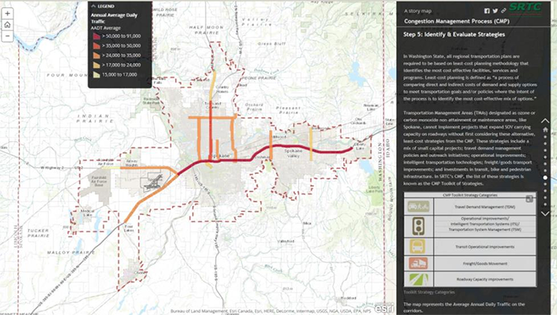
Figure 4. SRTC toolkit with geospatial data/features that may help SRTC assess its progress toward meeting Horizon 2040 regional goals.
C. Data Stewardship
As the peer agencies have continued to explore how to effectively use geospatial/GIS tools and applications to support TPM goals, they reported experiencing challenges with engaging in effective data stewardship: in other words, how to effectively collect system performance data, integrate them into existing decision-making processes, and update data over time. While data stewardship presented difficulties, peers believed that this was critical to adopting a TPM approach. Having access to accurate, up-to-date, system information—data that all stakeholders “trust”—will support appropriate and effective evaluation of the entire transportation system's performance. Peers also noted the importance of developing common data standards and formatting practices to ensure that different datasets can be linked and are appropriately scaled.
Peers reported working to improve performance data stewardship practices by compiling datasets and data sources that might currently exist in disparate places and simplifying data collection/maintenance processes with improved tools (particularly using mobile applications that permit in-field inputs). To ensure that data updates occur regularly and consistently, some peers have piloted or implemented initiatives to ensure that performance data (especially asset condition or maintenance data) are compiled on a more regular basis.
Data Collection/Compilation/Integration
Peers are compiling geospatial data for system performance monitoring from a wide variety of sources, including locally sourced datasets, data from other State DOTs and FHWA, and datasets from private industry providers. Multiple peers are exploring the use of the National Performance Management Dataset (NPMRDS) as a resource to support performance analysis.9 The All-Roads Network of Linear Referenced Data (ARNOLD), which requires State DOTs to report geospatial data representative of their public roads to FHWA as part of the HPMS, may also serve as a resource to support States' or MPOs' TPM efforts.
Peers discussed the importance of compiling performance data into a central repository. Such a tool would make performance information more accessible to users within (and possibly outside) the agency. Tools with visualization capabilities might also help communicate information to internal and external stakeholders. This would help agencies to “tell a story” about how the transportation system is doing, providing context for future investment decision-making.
Peers believed that while there are potential benefits of having a centralized repository for performance information, developing such tools may come with particular challenges such as whether/how to share highly localized data. To address these and other challenges, peers discussed the necessity of documenting (for both agency leadership and the public) the potential benefits that would be realized. These benefits might include increased access to system data, increased transparency of transportation system performance and agency decision-making process for the public, time- and cost-savings, and improved data quality.
- Peer Example: MDOT is currently developing a PBM framework with several components. One component will be to define and draft appropriate maintenance performance measures; MDOT is currently drafting measures for three categories of maintenance assets: roadway, roadside, and traffic safety. A second component will be to develop a performance monitoring system, which includes a geospatial-based tool, or suite of tools, to help compile performance information and can support MDOT in evaluating progress against the chosen measures over time. As part of this component, MDOT is piloting MiMRS—described in more detail in the “Data Maintenance” section below—to help quantitatively benchmark performance. The third component of PBM will be linking maintenance data into a new GIS-based tool called the TAMS to present a more unified, cohesive view of transportation system performance as a whole.
- MDOT initiated development of TAMS in June 2015. TAMS is designed to integrate MDOT's existing GIS data on road network management, asset inventory management, and maintenance. TAMS will also provide a common standard for these data to promote easier access to and application of information. It will provide functionality to allow MDOT staff to geolocate assets and store asset characteristics (e.g., condition, physical description) using one platform. At the same time, MDOT is exploring use of AGOL and mobile tools to enable staff to collect performance data and make data updates while in the field (see Figure 5). TAMS may integrate with these tools in the future. MDOT expects that TAMS will support the agency with the entire lifecycle of transportation performance management, from planning to designing and implementing projects, as well as operations, inspections, and maintenance of assets over time.
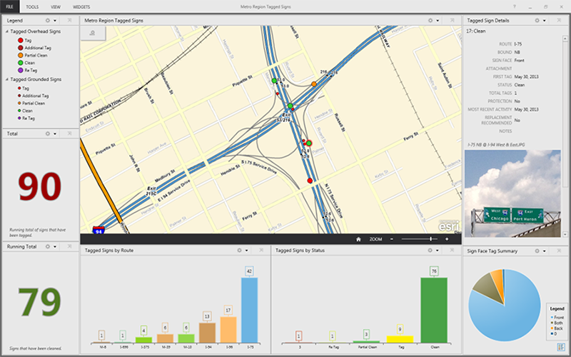
Figure 5. Example of how MDOT is currently using GIS data to support in-field performance monitoring—for live data collection on graffiti.
Data Maintenance
Peers agreed that performance data need to be kept up-to-date to ensure they can effectively support TPM goals. Many peers mentioned using mobile tools to support field staff in collecting and maintaining GIS data more easily and frequently.
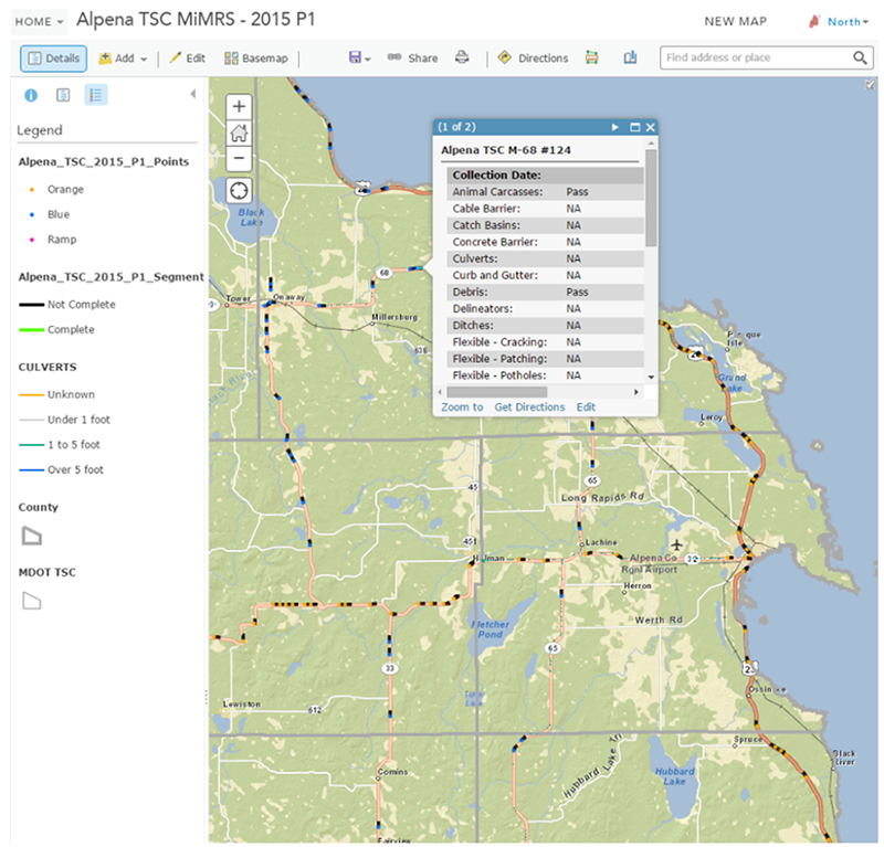
Figure 6. MiMRS data collection in graphical view, showing roadway segments in the north region of the State.
- Peer Example: MDOT's Region offices are responsible for day-to-day asset management decision-making. To move toward a more cohesive, performance-based maintenance approach for the State as a whole, MDOT is piloting MiMRS, which will compile data on asset performance for all State trunkline (see Figure 6). To collect data for MiMRS, half-mile segments of roadway are randomly generated and MDOT field staff use the ArcGIS Collector Application to collect data along these specific segments. Staff will typically drive through the segments on the roadway shoulder at speeds between 15 and 25 miles per hour to visually inspect pavement, guardrail, culverts and other assets. The data will then be integrated into a regional dashboard, which shows where data have been collected and number of segments complete.
- Peer Example: ODOT added Data2Go, a customized add-on, to FACS-STIP to support mobile collection and maintenance for ODOT's asset data (see Figure 7). The tool is specifically designed to help ODOT prioritize assets in need of improvement. ODOT also uses data collected by the tool to monitor assets in “fair or better” condition and to comply with road maintenance standards.
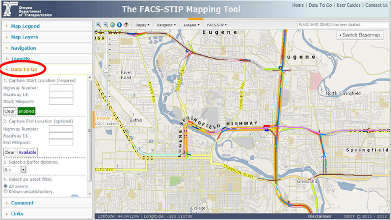
Figure 7. ODOT’s Data2Go Tool, with mobile functions highlighted.
D. Early or Anticipated Benefits of Applying GIS for TPM Goals
All of the peers recognized value in using geospatial/GIS tools and applications to support general performance management goals. But as the peers explore ways to use GIS tools for TPM-specific goals, many are anticipating additional benefits that may include improved coordination and collaboration and more strategic, effective investment decision-making. Peers expected to continue identifying these and other benefits as their efforts evolve over time.
Coordination and Collaboration
Peers believed that using geospatial/GIS tools and applications“particularly web-based tools”has generally made it easier to compile data from across an organization or from others. These tools are also supporting collaboration by making it easier to share information with different divisions or offices within an organization, other agencies, and the public. These benefits may help spur agencies to identify new opportunities for applying previously siloed data to support TPM-specific goals.
During the exchange, peers also discussed collaboration and coordination as strategies to address existing data gaps, in order to refine existing tools for TPM goals. For example, peers reported that in some cases, existing GIS tools promoted partnerships between transportation agencies and others; these partnerships could be leveraged to collect more robust performance data.
- Peer example: The ODOT office that spearheaded development of FACS-STIP was formed in 2007 as part of a strategic plan to build a more comprehensive asset management dataset. At that point, ODOT estimated it would take 25-30 years to develop a robust asset database, so the first iteration of FACS-STIP focused on providing a basic sense of current conditions without in-depth analysis. This early iteration enabled the ODOT FACS-STIP team and GIS developers to reach out to end users to solicit feedback. At the same time, the tool provided an easy means of networking across different parts of the organization. Later FACS-STIP iterations sought to make data increasingly accessible to even more users within ODOT. Over time this has led to an open and collaborative approach to asset management data collection that may provide a foundation for future ODOT TPM efforts.
- Peer example: Through partnerships with the University of Western Florida and with a local high school, St. John's County DPW is able to keep its asset management data up-to-date while contributing to the community. St. John's County DPW has had a long-time partnership with the University of Western Florida, which has an online GIS certification program. As part of its regular process for asset data maintenance, DPW convenes university interns to update data or collect new data. The interns update data for the county while earning credits for their GIS certification. Recently, DPW expanded this model to include students from a local high school's “Career Academy,” which has a program on using GIS for environmental management. DPW benefits greatly from this intern and student support, as it has a limited staff who do not always have the resources or time to engage in regular asset data updates or collection of new asset data.
Improved Investment Decision-Making
Peers noted one of the most important reasons for adopting performance-based approaches, including TPM, is for an agency to better evaluate past investments and improve investment decision-making. While the peers were overwhelmingly in the early stages of using GIS tools to tie performance data to investments, some agencies have already found success in using geospatial data to support discussions around where to make investments, evaluate potential or realized outcomes of these investments, and communicate to agency leadership or the public about these outcomes. Some peers have also found that using GIS has reduced the amount of time it takes to perform cost/benefit analyses that demonstrate the potential impact of a proposed investment.
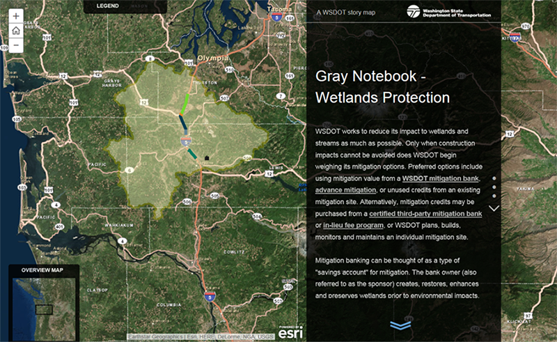
Figure 8. Example map from a Gray Notebook wetlands protection storyboard. The map depicts a corridor widening project that benefited from a WSDOT-owned wetlands site that provides compensatory mitigation credits.
- Peer example: The Flagstaff MPO is considering how to integrate existing AGOL data on regional transit and bicycle LOS into the agency's planning and programming processes. The ultimate goal of this effort is to better understand the costs and benefits associated with projects that promote mobility improvements. The MPO has faced past challenges in identifying the return on investment from projects that support improved bicycle LOS and increased accessibility for bicycles. The MPO also assessed a proposal from a local elected official to rerouting freight rail lines around the town, replacing existing lines running through the center of the City of Flagstaff. Using GIS data, staff were able to conduct a quick analysis to estimate the cost at around $500 million, an excessive cost for a town with a population of only 50,000. As a result, the MPO was able to present a strong case to leadership and the Flagstaff city council (within a short timeline) as to why a proposal to reroute the rail lines would not be a wise use of taxpayer funds.
-
Peer example: WSDOT uses GIS and AGOL to evaluate transportation performance and communicate the agency's performance story across a wide variety of multi-modal categories that include bicycle and pedestrian safety, congestion, transportation capacity, environmental stewardship, and freight mobility. The results of these analyses are included as part of the agency's quarterly performance update, the “Gray Notebook” and the annual “Corridor Capacity Report.” These reports provide a comprehensive look at transportation data within the State and identify performance indicators for its districts. WSDOT is currently integrating these indicators into an enterprise GIS to streamline performance reporting and asset management.
WSDOT believes that the Gray Notebook is supporting the agency to make investment decisions that are more transparent and credible. The use of GIS data to prepare performance analyses and maps for the Gray Notebook and Corridor Capacity Report has helped WSDOT more effectively communicate how projects are prioritized and why. In the future, the agency plans to use AGOL data to develop corridor-based storyboards that depict performance data for 10 urban corridors across the State. The storyboards will help the agency package data for internal use but also more effectively communicate decision-making strategies and outcomes to the public. WSDOT has existing storyboards depicting projects benefitting ferry and rail mobility, safety rest areas, and wetlands protection.
-
Peer Example: FDOT's Transportation Statistics Office has been exploring ways to integrate system data using GIS tools, particularly as that data can inform analysis of the value of recently-completed projects. For example, the PortMiami Tunnel, built through a public/private partnership including FDOT, opened in 2014 with the goal of improving traffic flows for passenger and freight vehicles in downtown Miami. To understand the benefits to freight providers and the travelling public, FDOT has summarized and imported NPMRDS data within ArcGIS and other software for use in assessing freight flows along specific corridors in the downtown Miami vicinity. FDOT hopes to use this analysis to study future freight corridors and to monitor long-term performance.
FDOT has also evaluated bicycle LOS along dedicated bike routes, in response to the recent designation of the AASHTO-approved US Bike Routes 1 and 90. These bike routes include sections along major arteries and highways, thus the Department began to explore safety for bicyclists along these corridors. Currently, bicycle lane data is stored in the FDOT's Roadway Characteristics Inventory, while crash data, including locations involving bicycles, is maintained by the FDOT Safety Office. By integrating this data, FDOT was able to show that there were more crashes per capita on stretches of roadway that had neither a bike lane nor a shoulder. FDOT anticipates using this merged GIS data, along with traffic volumes and bicycle counts, to identify potential problem areas and make suggestions for new bike lanes or wider shoulders.
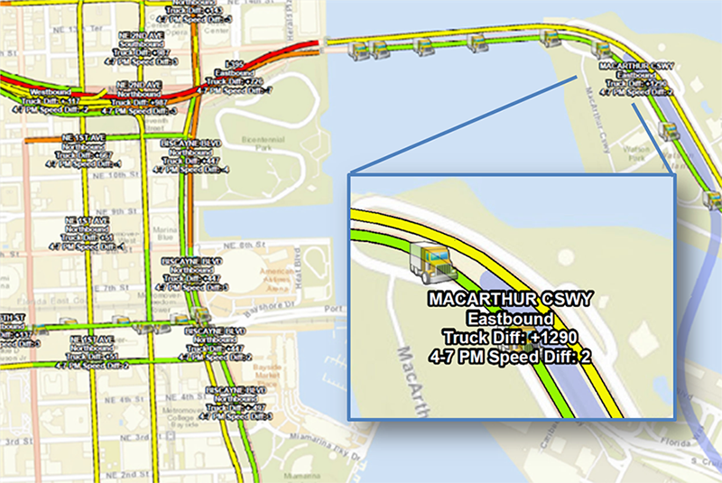
Figure 9. Differences in 4:00-7:00 PM Weekday Average Truck Speed around the Port Miami Tunnel, May 1-7, 2014 vs May 1-7, 2015.
E. Conclusion
Over the course of the peer exchange, participants identified general lessons learned from their efforts to date:
- Consider strategies to help build momentum. Peers believed that they are making progress in using geospatial/GIS tools and application for performance management, but noted that a challenge is how to effectively build momentum and support within an agency to adopt a system-based performance-based approach. Peers cited a few reasons for this challenge including inadequate staff and funding resources, addressing different legislative priorities, and difficulty securing licenses that permit GIS tool deployment for multiple users across an organization. Many peers believed that transportation agencies would not fully realize the benefits of applying GIS/geospatial tools and applications for TPM goals unless their organizations adopted a strong culture of data-driven decision-making. Peers are exploring strategies that can encourage internal buy-in and promote cultures conducive to using GIS tools for TPM goals; for example, some peers are documenting and sharing the benefits of these tools.
- Consider coverage for performance data. Peers noted that there is a wide range of coverage for GIS transportation performance data. State DOTs and MPOs may benefit from having access to national-level, aggregated datasets such as ARNOLD/HPMS or NPMRDS that provide performance information for interstates or National Highway System (NHS) roads. However State DOTs and MPOs seeking local-level performance information may need to carefully evaluate what resources currently exist, identify data gaps, and assess strategies for gathering or acquiring data when needed. Peers suggested that engaging in partnerships with other stakeholders—including FHWA, State DOTs, MPOs, local agencies, and the academic/research community—may help achieve economies of scale for collecting and applying transportation performance data.
- Ensure that GIS-TPM tools are user-friendly. As agencies mature their efforts to develop geospatial/GIS tools and application to support TPM goals, they should develop protocols and standards to ensure efficient data collection and maintenance. Agencies should also strive to ensure that GIS-based TPM tools are usable by staff without specialized GIS expertise, since this will make it more likely that such tools can be easily integrated into agency workflows and decision-making processes.
-
Share information about how geospatial/GIS tools and applications can help meet MAP-21 performance requirements. Peers expressed uncertainty about what is necessary to fulfill MAP-21's national performance goals, given forthcoming TPM rules. Peers expressed a desire to continue networking with others and with FHWA to share noteworthy practices, lessons learned, and considerations for how to effectively apply geospatial resources for TPM.
Peers also expressed interest in having additional guidance from FHWA about how to address gaps among datasets such as the NPMRDS, which many agencies are exploring (or considering exploring) to support future TPM efforts. FHWA noted that the Capability Maturity Model (CMM) currently in development will assist peers and others in responding to MAP-21 national performance goals.10 Stakeholders will be able to use the CMM to assess their level of maturity for performance management and receive specific information on how to improve the state of the practice for their agency. FHWA asked that peers share examples of training materials, job descriptions, and data management processes to help refine the CMM.
Peers suggested some strategies that could be taken at the Federal level to better support State DOTs and local agencies as they prepare to address MAP-21 national performance goals. For example, peers noted that they would appreciate learning more about how others across the country are using geospatial/GIS tools to compile or manage performance data to support decision-making, particularly in terms of challenges they are facing and how they are addressing the challenges. Peers also wanted to learn more about risks that different agencies have faced when moving forward with GIS for TPM initiatives, such as funding limitations. Peers were particularly interested in ways to mitigate and address risks early in the process.
The majority of peers believed that they are still in the early stages of exploring or considering how to effectively use geospatial/GIS tools and applications for TPM. Some of the peers anticipate refining, tailoring, or evolving current performance management tools to support broader TPM goals over time. Most peers are focusing on laying the groundwork to ensure more consistent collection or maintenance of performance data over the long-term and identifying strategies to encourage an organizational culture that prioritizes data-driven decision-making. Peers mentioned that existing data on travel times, asset condition, and other attributes may reduce the need for new data collection. Likewise, mobile technologies may simplify the process of collecting performance data and monitoring performance and asset condition. However, addressing data gaps continues to be a challenge.
Despite the challenges discussed, peer exchange participants are recognizing important benefits in using geospatial/GIS tools and applications to support a range of performance management goals that may be extended to include TPM in the near future. These benefits include easier compilation and integration of transportation performance data, the ability to visualize agency decision-making outcomes, more effective communication of performance data both within an agency and with others including the public, and the ability to promote a holistic, systems approach to managing the transportation network.
Back to Top
APPENDIX A: PEER EXCHANGE AGENDA AND PARTICIPANTS
FHWA Peer Exchange: Uses of GIS for Transportation Performance Management
221 W 1st Ave #310, Spokane WA 99201
June 30-July 1, 2015
Peer Participants
US DOT Participants
Peer Agenda
| Tuesday, June 30 |
| 8:45 – 9:15 |
Welcome and Introductions – SRTC |
| 9:15 – 9:45 |
Overview of USDOT GIS and TPM Initiatives – FHWA |
| 9:45 – 10:30 |
Demonstrations/Presentations 1
- SRTC: Exploring Uses of GIS for TPM (e.g., Horizon 2040, Congestion Management Process)
|
| 10:45 – 11:45 |
Roundtable 1: Using GIS to Support TPM Decision making – All Participants |
| 12:45 – 1:30 |
Demonstrations/Presentations 2
- MDOT: Development of a Performance-Based Maintenance System and a Transportation Asset Management System
|
| 1:30 – 2:15 |
Demonstrations/Presentations 3
- St. John's County DPW: Integrating the Computerized Maintenance Management System (CMMS) with GIS for Asset Management
|
| 2:30 – 3:00 |
Demonstrations/Presentations 4
- FDOT: Florida's Performance-Based Planning and Programming Process
|
| 3:00 – 4:00 |
Roundtable 2: Using GIS to Improve TPM Data Management and Analysis – All Participants |
| 4:00 – 4:15 |
Day 1 Key Points/Wrap-Up – FHWA |
| 6:00 |
Informal Dinner (Location TBD) |
| Wednesday, July 1 |
| 8:00 – 8:15 |
Day 1 Re-cap – FHWA |
| 8:15 – 9:00 |
Roundtable 3: Using GIS to Improve TPM Communication and Collaboration – All Participants |
| 10:00 – 10:45 |
Demonstrations/Presentations 6
- ODOT: Features, Assets, and Conditions Survey Statewide Transportation Improvement Program (FACS-STIP) Tool
|
| 10:45 – 11:45 |
Roundtable 4: Moving Forward with GIS for TPM Activities – All Participants |
| 11:45 - Noon |
Day 2 Key Points/Wrap-Up – FHWA |
| Noon |
Adjourn |
Roundtable Discussion Questions
Roundtable 1: Using GIS to Support TPM Decision making
All Participants
-
Can you provide examples of how your agency has used GIS to:
-
Establish performance baselines and set targets?
- What are different technical approaches?
- How has your agency integrated these approaches into its business processes?
- Support performance-based planning (e.g., to identify agency performance strategies/priorities or investment tradeoffs?)
- Support decision making in other ways?
- How do you effectively adjust/adapt measures over time? How do you adjust the scope or geographic scale of these measures to “zoom in or out?” What are some good examples in these areas?
- What have been some outcomes or results of these activities?
- Are you working across disciplines (e.g., with safety, operations, etc.) within your agency on these initiatives? Is there corporate/executive level involvement? How do you make organizational/structural changes to keep pace with changing directions of GIS efforts or programs?
- What have been the biggest successes or challenges experienced in using GIS for decision making? What about lessons learned?
Roundtable 2: Using GIS to Improve TPM Data Management and Analysis
All Participants
- What architectures/systems is your agency using for asset management and data management? How does GIS interact with these systems?
-
How does your agency collect asset data or other data for TPM?
- What has worked well in terms of collecting or compiling asset data?
- Where have there been challenges?
- How do you ensure the quality/accessibility of asset data or other data for TPM?
- What kinds of GIS data governance systems does your agency have in place?
-
Can you provide examples of how your agency is using GIS to support:
- Project prioritization?
- Data visualization for TPM?
- Performance diagnostics (e.g., analyzing performance metrics)?
- Predictions of transportation system performance?
- Data management?
- Has your agency tried to calculate the return on investment of your GIS/TPM investments? If not, is this something you might focus on in the future?
- What have been the biggest successes or challenges experienced in using GIS for data management and analysis? What about lessons learned?
Roundtable 3: Using GIS to Improve TPM Communication and Collaboration
All Participants
-
Can you provide examples of how your agency is using GIS to support:
- TPM performance monitoring and adjustment (e.g., monitoring program delivery or transportation system performance and making changes as needed over time)?
- Enhanced TPM reporting and communication efforts, including both internal and external reporting?
- Collaboration with external agency partners, (e.g., around planning, programming, or monitoring?)
- What have been the biggest successes or challenges experienced in using GIS for communications and reporting? What about lessons learned?
Roundtable 4: Moving Forward with GIS for TPM Activities
All Participants
-
Based on conversations held during the peer exchange and your own experiences, what can USDOT do to support you in your GIS-TPM activities moving forward (e.g., produce case studies, develop guidance, maintain a Community of Practice for these issues, develop a training, hold a webinar)?
- What specific topics would you most like to learn more about from FHWA?
- Are there GIS-TPM topics that you would like to bring up or discuss that we did not have a chance to talk about earlier in the peer exchange?
- What role does your agency anticipate GIS playing in efforts to implement MAP-21 performance provisions?
- Assuming FHWA will produce a case study report on the topic of using GIS for TPM activities, what issues or topics would you most like to see highlighted as part of that report? Do you have any suggestions for case studies to highlight?
Back to Top
FOOTNOTES
Back to Top