A Newsletter from the Federal Highway Administration (FHWA)
www.gis.fhwa.dot.gov
SUMMER 2012
A Look at the Maryland State Highway Administration (MDSHA) and the Texas Department of Transportation's (TxDOT) Environmental Planning GIS Tools (EPGTs)
Upcoming Events
- National States Geographic Information Council (NSGIC): 2012 Annual Conference
September 9-13
- GIS-Pro: Urban and Regional Information Systems Association's (URISA) Annual Conference for GIS Professionals
Sept. 30-October
- Transportation Research Board (TRB) Annual Meeting
Jan. 13-17, 2013
This edition's Q&A is with Charlie Gischlar of MDSHA, who discusses the GIS-based EPGTs that the agency is jointly promoting with TxDOT.
What are MDSHA and TxDOT doing to promote these EPGTs?
MDSHA and TxDOT have joined forces to promote the expanded use of valuable EPGTs through the support of the American Association of State Highway and Transportation Officials' (AASHTO) Technology Implementation Group (TIG). AASHTO's TIG program seeks to identify innovative transportation technologies and accelerate their adoption by agencies nationwide. The EPGTs were selected by TIG as innovative technologies to share with other States.
What are EPGTs?
EPGTs provide scalable project development enhancements that use spatial technology merged with ecological science to analyze environmental assets and prioritize ecological resources and services. By effectively using existing and emerging environmental data assets and technology, the EPGTs allow transportation officials, planners, designers, and the public to better incorporate high quality resources and infrastructure needs in an integrated decision-making process. This “ecosystem approach” recognizes the interrelationship between healthy ecosystems, sustainable communities, and economies that rely on efficient transportation and investments.
What makes these tools unique?
EPGTs provide users with a wide spectrum of analyses, including potential environmental impacts associated with road improvements/construction or expansion, how resources should be prioritized to facilitate environmental protection and preservation, and the identification of potential future environmental mitigation or stewardship sites. The EPGTs are useful in evaluating both impacts on a single environmental resource and cumulative impacts on multiple resources.
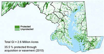 A map of Maryland's protected and unprotected green infrastructure (GI) developed using the GI Assessment, an EPGT.
Why should transportation agencies use EPGTs?
Natural ecosystems are disappearing rapidly due to development, but these areas are basic building blocks of human welfare. Transportation agencies are recognizing the value of natural lands for their stormwater management and sediment and erosion control services. Natural ecosystems also increase recreational opportunities and overall aesthetics.
Use of EPGTs can help transportation agencies, in partnership with resource agencies and/or environmental interests, identify and strategize resource conservation efforts. The tools rely on accepted scientific approaches to identify important resource features with high ecological value based on multi-media (vegetation, wetlands, surface waters, habitat, etc.) considerations. This approach provides a well-founded basis for identifying key conservation land priorities.
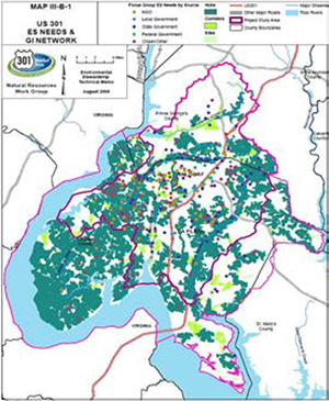 Environmental stewardship activities and priority natural resources identified through stakeholder outreach as part of the MDSHA GI Approach.
Additionally, the U.S. Environmental Protection Agency (EPA) and other regulatory agencies are moving toward using a broader ecosystem approach for transportation projects across the U.S. For example, by using a watershed approach, transportation planners can use “the big picture” to identify ecologically significant regions and help preserve these critical areas. Using EPGTs can help agencies to optimize both ecological and economic returns for transportation projects, large and small.
What EPGTs are you currently promoting?
There are many GIS-based EPGTs available to aid in transportation planning. The AASHTO-TIG EPGT Team is specifically focused on promoting five tools. These include the MDHSA GI Assessment and GI Approach. The GI Assessment, developed by the Maryland Department of Natural Resources (DNR), is a GIS tool that identifies and prioritizes areas in Maryland for conservation and restoration. MDSHA integrated this into the GI Approach, which considers additional important environmental resources, and is used in the development of transportation infrastructure projects statewide. This approach complements strategic conservation and environmental protection objectives.
The AASHTO-TIG EPGT Team is also promoting NEPAssist, TXDOT's Ecological Assessment Protocol (TEAP), and the GIS Screening Tool (GISST). TEAP is a screening-level tool that uses existing electronic data to map the most ecologically significant areas of the State, allowing environmental professionals to rapidly assess potential environmental impacts from large-scale projects. GISST is an EPA Region 6 tool that incorporates the TEAP and other GIS layers to assist in the initial assessment of potential environmental impacts. It uses scored criteria to rate project alternatives. NEPAssist is the EPA's web-based application that draws environmental data from regional EPA GIS databases to identify potential environmental issues.
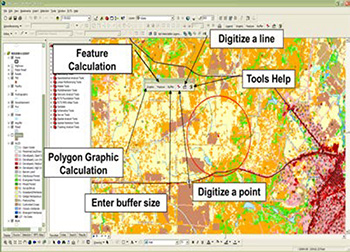 Screenshot from GISST.
What is required to implement the tools?
To effectively implement the EPGTs, users must inventory local, State, and national, planning, environmental and transportation agencies to discover what resources are readily available and what GIS data layers must be established. In addition, field studies may increase the effectiveness and cost benefits of using EPGTs.
Many GIS-based EPGTs are versatile in that they can be modified to fit an individual need. To effectively use the tools, in-depth knowledge of GIS is not necessary, but can be beneficial. Those with a GIS background can further modify a GIS tool for maximum benefit.
Does the project have to be a certain scope or size for the GIS tools to be effective?
The GIS-based EPGTs tools are scalable to provide for the needs of any project, large or small. Additionally, the tools can be used on national, state, regional or local levels.
Is training on EPGTs available?
There are numerous opportunities to become familiar with EPGTs. FHWA, as well as The Conservation Fund, the National Highway Institute, and the U.S. Fish and Wildlife Service (USFWS) all offer additional training for GIS-based environmental planning tools.
Can agencies partner in using EPGTs?
Agency partnerships are key components to effective development of EPGTs. GISST was developed through a partnership of the EPA and TxDOT on the Interstate 69 corridor project. Along with The Conservation Fund, MDSHA, the Maryland DNR, and USFWS developed and implemented the GI Assessment and Approach for the US 301 Waldorf Area Transportation Improvements Project in southern Maryland.
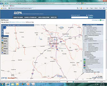 Screenshot from NEPAssist, which draws environmental data from EPA GIS databases and web services.
For additional information about these tools including case studies and team contact information, please see the AASHTO TIG EPGTs webpage.
A guidance document will be posted on the webpage in Fall 2012 which will contain:
- Information on adoptable concepts and tools to advance the use of GIS and environmental data in the development of transportation and support infrastructure;
- Shared knowledge and experiences from others regarding the benefits of using enhanced GIS technology and integrated decision-making;
- Important assessment considerations and requirements for implementing GIS tools; and
- Links to valuable GIS data, tools and other initiatives to help you develop a program which best fits the objectives and resources of your agency.
Charlie Gischlar
CGischlar@sha.state.md.us
(410) 545-0311
Adopting Appropriate GIS/IT Technologies for GIS-T Integration:
Editorial from Jake Payne, Database Administrator and Information Technology Architect, Utah Department of Transportation (UDOT)
UDOT is heavily engaged in the rollout of GIS technologies. This involves collecting and organizing vast amounts of institutional knowledge, which UDOT then relates to locations or roadways so that users can more easily find what they need. This experience has taught us some valuable lessons:
Do not allow vendors to dictate your architecture.
Each GIS vendor would like its products to be at the core of a State's GIS architecture. Rather than choose one vendor, we instead look at all vendor solutions as a big box of Legos. Legos are far more useful if you have more than one color and shape.
Focus on strengths.
Different vendors have different strengths. For example, Oracle is great at handling large quantities of data and ESRI is effective for spatially editing data, while Google is familiar to a wide audience. Both ESRI and Google shine at presentation and publishing, while open source tools such as GeoServer and other Open Geospatial Consortium-compliant software excel at tying everything together. By capitalizing on the strengths of a variety of products, UDOT has been able to produce better GIS solutions.
Do not overlook solutions from other IT domains.
We used some “old school” solutions when designing our GIS tools. For example, data warehousing techniques, such as partitioning and advanced indexing, are highly effective at solving GIS problems. By leveraging existing technologies, we were able to avoid re-inventing the wheel.
It is not just about the map.
While producing a map to visualize data is an important use of GIS technology, people working with the map also need to view and analyze the raw data using various techniques. For example, providing the raw data in Excel format can be just as important as producing a map.
Our development team at UDOT became much more productive when we rejected the notion that there is only one right way to implement GIS technology. Instead, we focused on the strengths of each vendor's product and kept an open mind to the potential of using existing “non-GIS” technologies.
Jake Payne
Jakepayne@utah.gov
(801) 965-4663
Other News
State and Local GIS Practices Database
FHWA recently completed a comprehensive update of its database of GIS transportation applications that are employed across the nation. Sixty new applications were added and 100 existing applications updated.
Information about each application can be found at https://www.gis.fhwa.dot.gov/gis_practices.aspx. Please visit the site to learn more or to submit information about your agency's transportation GIS applications.
Webinars
FHWA sponsors a quarterly GIS webinar series that provides information about current GIS efforts, applications, and initiatives. Planners from State Departments of Transportation (DOTs), Metropolitan Planning Organizations (MPOs), and others are particularly encouraged to attend. To view previous webinars, please see http://www.gis.fhwa.dot.gov/webinars.aspx.


