A Newsletter from the Federal Highway Administration (FHWA)
www.gis.fhwa.dot.gov
SUMMER 2009
A Look at the Puerto Rico Highway and Transportation Authority's Use of Geospatial Technologies
This month's Q&A is with Miguel Martínez Yordán of the Puerto Rico Highway and Transportation Authority (PRHTA). He discusses how the agency uses geospatial technologies to meet its transportation needs.
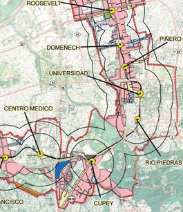 Excerpt from the PRHTA Transit-Oriented Development Plan
Q. What transportation needs exist at your agency?
A. In Puerto Rico, the current main concern in terms of transportation needs is the completion of an intermodal project to incorporate the Urban Train system with the metropolitan bus system and public roads. PRHTA is developing a transit-oriented development plan to increase the density of housing, business and public and private services in the surrounding areas of the main entrances of the Urban Train. GIS is being used to digitize and analyze every route of the system to establish connections between each mode in travel demand forecasts and service areas.
Q. Why was GIS chosen as a tool to meet these transportation needs?
A. GIS (ESRI ArcGIS) is already the main analysis tool for the Strategic Planning Office. The tool has been proven to provide good results for both routing projects and analysis.
Quarterly Webcast
On June 10, 2009, FHWA hosted its third quarterly webinar on GIS in Transportation. The topic of the webinar was the evolution of the Maryland State Highway Administration's (MDSHA) road centerline and development of One Maryland, One Map. Speakers from MDSHA, the Maryland Department of Planning, the Maryland Governor's Office and Towson University's Center for GIS, presented to more than 70 participants. More information can be found at www.gis.fhwa.dot.gov/
webinars.aspx.
The next webinar is scheduled for fall 2009.
Q. How else does PRHTA use GIS to meet business needs?
A. PRHTA uses GIS technology and databases to visualize the geography of specific regions. In addition, GIS is used to determine mobility conditions and the
interconnections that can be made via intermodal infrastructure.
The GIS-based linear referencing tool has played a major role in terms of spatial analysis at PRHTA. Most of the agency's infrastructure data is in tabular form with the kilometers element as the official site location for measuring distances and material quantities for maintenance.
Q. Who currently uses GIS?
A. The primary end users of geospatial technologies are state government, municipalities, and the private sector.
Q. How and when was use of GIS initiated to meet PRHTA's business needs?
A. In the late 1980s, the "GEOSYSTEMS" project was conceived in Puerto Rico to incorporate geospatial technologies on a daily basis for decision-making. The first GIS-based road dataset came from the digital line graphs of the U.S. Geological Survey topographic quadrangle maps. Since then, updates have been made to maintain an official Puerto Rico state road map.
Together, the Puerto Rico Planning Board and PRHTA have been the main agencies developing geospatial technologies. Each agency has an official GIS office where various projects and GIS management takes place.
Q. What other factors contributed to PRHTA's use of geospatial technologies?
A. GIS can help meet the need for precision and effectiveness in the planning process. GIS can also help create visualization tools for the end user.
Q. Where do you obtain data?
A. Geospatial data are mainly obtained from different government agencies and municipalities. Very few data come from the private sector.
Q. Are there challenges in securing funding for use of geospatial technologies?
A. Not at the moment. However, current fiscal conditions might be a key factor influencing future funding for GIS and transportation planning. In the last few years, Federal funding has provided approximately 80% of funding for PRHTA's GIS and transportation planning projects.
Q. Are there future plans to change or modify how PRHTA uses geospatial technologies?
A. Yes, there are plans to serve PRHTA's spatial data through the Internet and even sell products the same way. Currently, PRHTA sells aerial photographs from 1930 to 2007 via the Internet. By offering these images online, people from all over the world can access the entire image catalog.
Q. What have been the critical success factors or lessons learned while applying geospatial technologies to meet PRHTA's needs?
A. Definitely the critical lesson learned is the big demand that users have for the technology and the data. Users who access geospatial data for the first time are amazed by the analysis they can conduct and the short time it takes to get good results. Manual research that used to take weeks might only take hours or even minutes with geospatial technologies.
FHWA Guest Editorial
Get Ready for GIS-T 2.0
Editorial from Dave Fletcher, Geographic Paradigm Computing, Inc.
Over twenty years ago, I had the rare opportunity to witness the birth of the GIS in transportation (GIS-T) industry. Indeed, some people refer to me as one of its "founders." Born of revolutionary technological innovations, including the desktop microprocessor, digital raster graphics and the early offerings of pioneer GIS companies, and nurtured by visionary champions at FHWA, the American Association of State Highway and Transportation Officials and the Transportation Research Board, GIS-T slowly matured into the mainstream offering we use today.
With the passion of doting relatives, our "family" spent years defining and refining, discussing and debating, and designing and deploying core GIS-T concepts such as linear reference, dynamic segmentation, GIS-T architectures, and standards until there was little left to shape. And so, with the mixed emotions familiar to many of you, I say, "congratulations, GIS-T! You are all grown up now."
Of course, the story does not end there. New technologies as revolutionary as those of the early 1980s have been developed. Young, creative, and passionate professionals are looking to make their mark on a world that offers ever more daunting challenges. It is time once again to begin a conversation about the next generation of GIS-T.
Upcoming Events
- Society for Conservation GIS Annual Conference
July 18-21, 2009; Big Bear Lake, California.
- 2009 Urban and Regional Information Systems Association Annual Conference
September 29-October 2, 2009; Anaheim, California.
- 9th International Symposium on GIS and Computer Cartography for Coastal Zone Management
September 30-October 2, 2009; Santa Catarina, Brazil.
Perhaps the single most innovative idea contained in GIS-T 1.0 (and later adopted by the far larger geospatial community) is that location itself could be used as a logical and physical strategy to integrate data. The Multi-Level Location Reference System (MLLRS) was created. Although the MLLRS allowed a clearer vision of where things were and when they occurred, the GIS community still struggled with issues of significance, context, meaning, and terminology. We urgently need better geospatial strategies. I foresee that automating the language of transportation geography in GIS-T 2.0 will be as radical as automating its cartography was a generation ago.
Not surprisingly, the systems deployed adopted engineering approaches, metaphors, and terminology. We planned, designed, built, maintained, and operated our GIS-T 1.0 infrastructure the way that we did our highways. Our perspectives were architectural, our achievements were measured by infrastructure output, and our focus was on project delivery. Contrast this "provider-centric" approach with a GIS-T 2.0 service-oriented computing environment that focuses on information delivery, supporting multiple points of view, and speaking in the diverse dialects of an unknowable and constantly changing user community.
Similarly, content providers no longer define the value of geospatial data. Rather, value is determined by many thousands of ad hoc judgments emerging from the collective experiences of information consumers. Rigid, standardized terminologies give way to smarter search engines as organizations concurrently rethink ways of exploiting technology without making large capital investments.
Envision the new world of GIS-T 2.0 where geospatial transportation information is delivered on-demand by many competing providers in a wide variety of formats "mashed" onto an amazing array of devices.
Please join me in welcoming the newest member of our family: GIS-T 2.0.
A NEW VISION FOR GIS-T
| |
GIS-T 1.0 |
GIS-T 2.0 |
| System Strategy |
Integration by Location
- Multi-Level Location Reference
- Dynamic Segmentation |
Integration by Language
- Adaptive feature ontologies
- Natural/web languages
- Geospatial catalogs/portals |
| System Pattern |
Tightly Coupled Architectures
- Technology
- Geodatabases
- Institutions |
Loosely Coupled Services
- Specialized Search Engines
- Data-in-the-Cloud
- Communities of Practice |
| System Point of View |
GIS-T Provider |
Transportation Information Community |
| System Quality |
Metadata-"Truth-in-Labeling"
- Positional accuracy
- Attribute accuracy
- Logical consistency
- Completeness
- Lineage |
Praxis-"Knowledge through Use"
- Availability
- Usability/ Reusability
- Utility
- Affordability
- Reliability |
| User Experience |
Visual (map) |
Multi-media (mash-up) |
Other News
Recent Reports
Upcoming FHWA GIS Peer Exchanges
- Three-Dimensional Visualization
July 8-9, 2009; Raleigh, North Carolina.
- GIS Applications for Eco-Logical: An Ecosystem Approach to Developing Infrastructure Projects
July 22-23, 2009; Austin, Texas.
Over the last year, FHWA has released several reports related to applications of GIS for transportation decision-making. These reports, listed below, are available along with many others at FHWA's GIS in Transportation website: www.gis.fhwa.dot.gov. Visit the site to learn more about these reports, as well as submit information about your agency's transportation GIS applications.
GIS Applications for Bicycle and Pedestrian Planning (July 2009) — This report provides a summary of a 1.5-day peer exchange held in Miami, Florida, in May 2009. The peer exchange was sponsored by the FHWA's Office of Interstate and Border Planning.
GIS Applications for Transportation Right-Of-Way (September 2008) — This report provides a summary of a 1.5-day follow-up peer exchange held in July 2007. The peer exchange was sponsored by the FHWA's Office of Interstate and Border Planning and Office of Real Estate Services.
For More Information
For more information about this newsletter, please contact Mark Sarmiento, FHWA Office of Interstate and Border Planning, mark.sarmiento@dot.gov.


