A Newsletter from the Federal Highway Administration (FHWA)
www.gis.fhwa.dot.gov
SPRING 2014
A Look at Illinois' Department of Transportation Automated Over-Dimension and Oversize Permit System
This month's Q&A is with Geno Koehler and Jim Conlon of the Illinois Department of Transportation (IDOT). They discuss IDOT's new over-dimension and overweight permitting system, called the Illinois Transportation Automated Permit (ITAP).
Upcoming Events
- URISA's GIS-Pro 2014: Leveraging Spatial Technology to Support Sustainable and Resilient Communities
Sept. 8-11, 2014
New Orleans, LA
- National States Geographic Information Council's 2014 Annual Conference
Sept. 14-18, 2014
Charleston, SC
- URISA Leadership Academy (ULA)
Oct. 13-17, 2014
Louisville, KT
- Transportation Research Board (TRB) Annual Meeting
Jan, 11-15, 2015
Washington, D.C.
What is the history of over-dimension and overweight permitting at IDOT?
Like other State DOTs across the country, IDOT is authorized by law to issue special permits to allow the operation of vehicles or loads that exceed the legal maximum dimension and weights on highways under IDOT's jurisdiction (i.e., Federal and State non-local highways). IDOT issues approximately 250,000 of these special permits each year.
Historically, the issuing process was supported by a data processing system that included a combination of many systems and staff to handle original permit filings and permit revisions. Motor carriers and their agents would submit applications for special permits in person and by mail, fax, telephone, and via web forms. IDOT permit staff would review the applications for accuracy, conformance with law and administrative rule, and confirm that selected routes were appropriate given the size and weight of the vehicle.
This system, while functional, had deficiencies that imposed limitations on applicants and IDOT. For example, permit office staff needed to spend large amounts of time reviewing applications, and staff needed to manually check submitted routes against GIS maps. There was also a lack of communication with local jurisdictions and no mechanism for permit office staff to verify applicant compliance with other laws.
To address these issues, IDOT set out to improve the over-dimension and overweight permitting process by building a fully web-enabled permit application: ITAP. Geospatial technologies are critical to the success of ITAP, as they allow the system to automatically route a vehicle while considering the load characteristics and roadway factors that impact travel.
What is ITAP?
IDOT implemented ITAP in January 2013. The system accepts online applications for over-dimension and overweight permits and allows for online payment via credit card, electronic funds transfer, and escrow and bonded accounts. It also electronically issues permits. A core feature of ITAP is a GIS-based navigation system (see Figure 1) that selects optimum routes based on user-entered information on vehicle origin and destination, as well as vehicle dimensions, obstructions (clearances), and restrictions at the time of the proposed move.
The overall purposes of ITAP are to streamline the process for issuing permits and provide a mechanism to more effectively notify local jurisdictions when a permit is issued. This helps jurisdictions know when over-dimension and overweight vehicles or loads might traverse local roadways. Since ITAP also provides applicants with local jurisdiction contact information, it helps operators communicate more efficiently with jurisdictions.
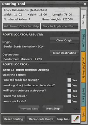 Figure 1. ITAP's GIS-Based Navigation System.
What are ITAP's geospatial components?
ITAP includes several geospatial tools:
- Network Datasets – IDOT developed a set of network datasets that are the key component for automated vehicle routing. These network datasets enforce custom business and routing rules that include vertical clearances, obstructions, permanent restrictions, turn restrictions, and roadway jurisdiction. The datasets are rebuilt nightly with a series of geoprocessing tasks.
- Restriction Editor – IDOT created a restriction editor using Esri's ArcMap for permit office staff to manage obstructions and restrictions (both temporary and permanent) along roadways. Permanent restrictions occur on state roadways and can be dimensional restrictions, weight restrictions, and closed bridges, as well as areas where all permit loads are restricted from traveling. All structures posted with a ton limit are permanently off-limits for permit loads. Temporary restrictions are dimensional limitations or closures on stretches of roadway for a given time frame. Usually these are active construction areas or emergency closures. A set of quality control tools are included in the restriction editor for data verification. Permanent restrictions are integrated into the network as part of the nightly build; temporary restrictions are factored in during route generation.
- Automated Permitting – IDOT uses Esri's ArcGIS Server Network Analyst for permit route generation. End users proceed through a series of steps to define their proposed move. The route generation software solution combines end user inputs, the road network with attached restrictions, and on-the-fly barrier placement to generate a permitted route. The result is a set of turn-by-turn driving directions along with a map for the issued permit (see Figure 2).
- Vertical Clearance Verification – IDOT entered into a contract with Mandli Communications to measure vertical clearances for use in the ITAP routing process. Once delivered, IDOT analyzed the data and resolved any issues before applying the new measurements to the database of vertical clearances maintained by the permit office. IDOT's central office and district personnel then used a GIS interface to display and update the measurement data.
How has the use of ITAP benefitted IDOT and its customers?
ITAP benefits IDOT by providing an application for automated processing and issuance of the majority of State jurisdiction permits. Use of ITAP has resulted in better customer service and more efficient and effective use of IDOT staff resources and time. Industry stakeholders seeking permits can obtain proper authorization within minutes and at any time for most permit requests. Since its inception, ITAP has processed over 310,000 permits. Nearly three-quarters of these permits have been handled automatically. The remaining permits are typically “superloads” that require additional review and/or bridge analysis before they can be processed.
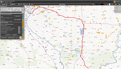 Figure 2. Issued Permit Route.
What were the critical success factors?
The most critical success factor was the ability to manage and trust the source data for vertical clearances. In the past, institutional knowledge and years of experience allowed permit writers to select known routes to route vehicle and loads with certain dimensions. With ITAP, IDOT can rely on actual vertical clearance and other restriction data that are incorporated into the network datasets and considered in the route solve function. Bad or inaccurate data could result in a bridge hit or other undesired event.
What are future plans for ITAP?
IDOT staff will continue to improve ITAP to better meet external customer needs as well as internal management and processing of permits. One significant anticipated enhancement includes integrating bridge analysis software into ITAP routing. This will increase ITAP's efficiency by further reducing the need for manual intervention by staff. Some other examples of future enhancements could include adding a mobile interface and local road permitting feature.
For more information, please contact:
Geno Koehler
Email: Geno.Koehler@illinois.gov
Phone: 217-782-7328
Jim Conlon
Email: Jim.Conlon@illinois.gov
Phone: 217-558-0302
Revolutionizing Transportation: Realizing the Full Potential of GIS
Editorial from Gary Baker, GIS Team Lead, U.S. Department of Transportation (USDOT) Volpe Center
One of my first GIS projects as a university student involved analyzing mountain biking trails' susceptibility to erosion based on slope and proximity to water. I was fascinated by the ability of GIS to bring different thematic data layers together and analyze them to create new information. Now, 20 years later, I continue to be captivated by the power of geospatial technologies, and have a particular interest in using them to understand exponentially increasing quantities of data. While today's GIS technologies can offer so much to the transportation field, we have yet to take full advantage of these opportunities.
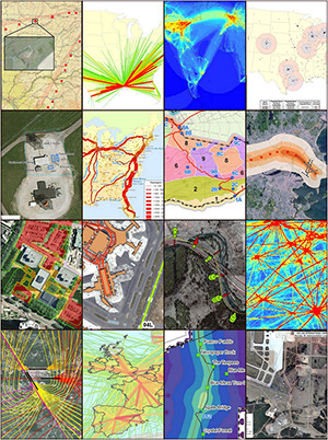 Figure 3: Images from a variety of transportation and GIS projects.
Many people still think of GIS technologies only as ways to produce maps. While working for USDOT, I have used GIS to analyze all modes of transportation from the global to the local levels. In my daily work, I use GIS to understand data, derive data, debug models, and, of course, communicate information. GIS is not only a tool to make a pretty picture; it is often an integral part of an entire project. Overall, using GIS gives us the ability to understand and convey information in ways not otherwise possible.
Online (web-based) GIS technologies are one large area of growth. Web-based GIS has matured significantly in the last couple of years. With all the geospatial data that is now being made available through REST (representational state transfer) services, transportation agencies are able to more quickly build online geospatial applications and combine data in new and interesting ways. Web-based GIS has also contributed to making GIS more accessible to everyone. People with little GIS expertise can perform geospatial data analysis in a fraction of the time they could previously.
Making geospatial data open and available to everyone is the key to getting the most out of GIS technologies in the transportation field. I believe that President Obama's recent executive order, which makes Federal government data open by default, is the type of thinking that can help transform us into more data-driven government agencies. By allowing easier access to data on sites like Data.gov, the Federal government can help the use of GIS technologies both within and outside the government.
Transportation by definition is geospatial. By thinking about GIS as more than just a tool to make maps, taking advantage of web-based technologies, making data more accessible to all and, most importantly, encouraging everyone to think geospatially, I believe that geospatial technologies can play a much bigger role in every area of transportation. These technologies should be a key part of understanding and communicating transportation information.
For more information, please contact:
Gary Baker
Email: Gary.Baker@dot.gov
Phone: 617-494-3631
Other News
Geospatial Data Collaboration (GDC)
GDC is a FHWA geospatial data-sharing initiative which encourages transportation agencies to use geospatial tools to share data, increase collaboration, and improve the quality and speed of transportation decision-making. GDC is one element of FHWA's Every Day Counts initiative, which is aimed at producing innovations, resources, and partnerships to shorten project delivery, enhance safety, and protect the environment.
FHWA held two peer exchanges this spring at which GIS practitioners gathered to share and learn about effective GDC practices. Lessons learned at the peer exchange will be summarized in a report which FHWA will publish later this year. For more information on GDC, please visit www.gis.fhwa.dot.gov/gdc.aspx.
Webinars
FHWA sponsors a quarterly GIS webinar series that provides information about current GIS efforts, applications, and initiatives. Planners from State Departments of Transportation (DOTs), Metropolitan Planning Organizations (MPOs), and others are particularly encouraged to attend. To view previous webinars, please see www.gis.fhwa.dot.gov/webinars.asx.
For more information about this newsletter, please contact Mark Sarmiento, FHWA Office of Planning, at Mark.Sarmiento@dot.gov.


