A Newsletter from the Federal Highway Administration (FHWA)
www.gis.fhwa.dot.gov
SPRING 2013
A Look at the Wisconsin Department of Transportation's (WisDOT) Use of Statewide Crash Mapping Capabilities
Upcoming Events
- COM.Geo 2013: International Conference on Computing for Geospatial Research & Application
July 22-24, 2013
San Jose
- GIS-Pro 2013: URISA's 51st Annual Conference for GIS Professionals
September 16-19, 2013
Providence, RI
- GIS in Transit Conference
October 16-17, 2013
Washington, D.C.
- National States Geographic Information Council’s Annual Conference
October 27-31, 2013
Kansas City, MO
This edition's article is written by Xiao Qin, Ph.D., PE, of South Dakota State University, and Kelly Schieldt of the Wisconsin Department of Transportation (WisDOT). They discuss using the Crash-Mapping Automation Tool (C-MAT) and Wisconsin Information System for Local Roads (WISLR) to develop a statewide crash map.
With emerging federal requirements to expand Highway Performance Monitoring System (HPMS) reporting, State Departments of Transportation (DOTs) must begin to review infrastructure deficiencies from a statewide perspective. These agencies are becoming more engaged in local highway programs and are providing more oversight to local projects. A highway inventory built on geographic information system (GIS) can facilitate a programmatic transition to improve the overall transportation system design, management, and operational consistency. Amongst all the requirements, improving highway safety matters the most.
In particular, GIS-based crash maps are becoming the cornerstone of effective safety management systems. Visualizing crash locations on a map enables engineers to rapidly recognize crash patterns and geographic distributions. Analyzing spatial data offers multiple views, such as hotspot, corridor, and network perspectives. Linking highway attributes, such as roadway geometric characteristics, traffic information, and environmental factors, with crash data via a GIS platform empowers more sophisticated safety modeling and prediction. However, creating and maintaining a statewide map with state route and non-state route crashes can be complicated and expensive.
On a national level, the federal government has a long-term vision for State Departments of Transportation (DOTs) to report crashes on all public roads. Motivated by the challenge of creating a statewide crash map, South Dakota State University (SDSU) and the Wisconsin Department of Transportation (WisDOT) developed a Crash-Mapping Automation Tool (C-MAT) using programming languages Java, Oracle, and ArcGIS. In a typical crash report, the location is described by intersecting streets or highways, (e.g. “on highway,” or “at/from highway”) and the intersection distance and direction.
The C-MAT algorithm reads On/At locations from crash reports, identifies the corresponding nodes and links in a base map, and assigns them latitude and longitude coordinates. Seemingly straightforward, the algorithm must handle the difficulties in the descriptive accuracy of a crash record, e.g. street name, direction, distance, concurrent highway names, and alias.
To an intelligent algorithm, the quality of the base map is as critical as a reliable map is to a smart driver in a new city. WisDOT and SDSU selected the department's Wisconsin Information System for Local Roads (WISLR) to serve as the GIS platform for statewide crash mapping using C-MAT. WISLR is a link-node linear referencing system developed and maintained by WisDOT. This web-based, statewide road network combines roadway data for local roads and state highways with interactive mapping functionality. Counties and local governments annually report new construction, annexations, abandonments, resurfacing, etc. to WisDOT. WisDOT uses WISLR information to assist in the distribution of construction, maintenance, and operation funds, and in the collection of data for federal reporting requirements such as HPMS.
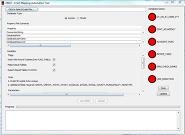 Screenshot of the C-MAT interface.
The C-MAT crash mapping process begins with finding the street or highway name. The roadway route table in WISLR contains a unique list of road names as well as their four components: (directional) prefix, (road) name, (road) type, and (directional) suffix. Comparing a highway or a street name in the crash report with the WISLR road names returns an extremely low match rate because crash location information is usually incomplete or incorrect, although partial information match can significantly improve the success rate. Each crash record's street name is then parsed into prefix, name, type, and suffix, and compared with the corresponding components in the WISLR table. The intelligent parsing algorithm built in C-MAT is capable of distinguishing four distinctive parts of a street name in spite of incompleteness, alternative names, or alias. The partial match algorithm starts with the most rigorous match, and the criteria are gradually relaxed until a successful match is found. This stepwise matching process provides great flexibility and is enhanced by a built-in spell-check module. Additionally, the match algorithm checks the adjacent municipalities of a crash if it cannot find a match in the area listed.
After the intersection has been mapped, C-MAT must identify the appropriate link as well as the link offset distance from the intersection for a segment-related crash. The process is completed in four steps: 1) locate all the links connecting to the intersection; 2) reduce the number of links to the ones bearing the street name on which the crash is occurred; 3) select the links using intersection direction, and identify the correct link. Based on whether the intersection is defined as the beginning of the link or the end of the link, the corresponding link offset is calculated by subtracting intersection distance from the link length or vice versa.
Recent enhancements to C-MAT include mapping the crashes that are referred to a mile marker or a bridge, e.g. overpass or underpass. The matching process is the same as mapping a crash to a node or a link but two additional tables are needed: a milepost table with WISLR link ID and offset for every milepost and a bridge table with the WISLR link ID and offset associated with each overpass or underpass bridge.
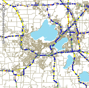
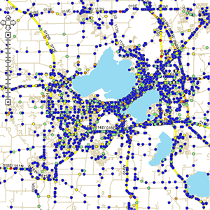
Screenshots of the WisDOT Crash Map showing the City of Madison 2012 crashes before the use of C-MAT (above) and after (below).
C-MAT has been thoroughly evaluated in terms of accuracy, precision, and completeness. Accuracy means the location of a geocoded crash has a high degree of conformity to the original crash location description. Precision means the geocoded position has a high degree of conformity with respect to the original crash location based on distance. Completeness is the percentage of crashes that can be geocoded with acceptable accuracy and precision, the ultimate measure of the power and robustness of the crash geocoding algorithm. Quality assurance and control (QA/QC) was performed by visually inspecting randomly sampled crashes across the state, which found that 86.44% locations are mapped correctly; 3.58% are mapped incorrectly; and 9.98% are not mapped. To deal with the unmapped and incorrectly mapped crashes, the group developed a flagging/debugging system to facilitate manual correction. The flagging system produces a confidence level that measures the quality of a mapped crash.
Current C-MAT has both desktop and server application. The desktop application is powered by Microsoft Access with a user-friendly graphical user interface (GUI), and the server application is powered by Oracle. C-MAT can map 83 percent of Wisconsin crash data collected between 2005 and 2009, approximately 603,000 data points, on the WISLR linework within two days. After excluding cases with missing location information, 90 percent of local, and 80 percent of state highway crash are mapped. State highway crash mapping will continue to improve as the quality of the state highway network in WISLR evolves.
WISLR continues to enhance business requirements in order to correctly display state roads for future analysis. For example, WisDOT is leading the coordination efforts with the University of Alabama (UA) Engineering Department to modify state highway dual carriageways and interchange location data in WISLR and in discussions with other agencies on adding addition location data. In recent years, WISLR data has assisted with state safety analysis for High Risk Rural Roads and rumble strip studies.
Using the statewide roadway network WISLR, C-MAT provides rapid, almost real-time mapping service. WisDOT's implementation of C-MAT substantially accelerates safety analysis for all public roads in the State.
For more information, please contact:
Xiao Qin, Ph.D., PE
Email: Xiao.Qin@sdstate.edu
Phone: (605) 688-6355
Kelly Schieldt
Email: Kelly.Schieldt@dot.wi.gov
Phone: (608) 267-9748
Optimization of Police Presence Using An Automated GIS Tool
Editorial from Allen Parrish, PhD, University of Alabama, and Dana Steil, PhD, Harding University
A partnership of computer scientists and law enforcement experts at The University of Alabama and Harding University have developed effective algorithms to position police resources to maximize their potential effectiveness in reducing automobile injury and fatality crashes. These algorithms provide police officers with maximally effective patrol routes that are applicable to both urban and rural roadways.
These algorithms also determine hot spots to support Data-Driven Approaches to Crime and Traffic Safety (DDACTS), the goal of which is to multiply the effectiveness of law enforcement by simultaneously addressing criminal incidents and crashes with the same patrol units. While the deployment of these algorithms is just beginning, the initial research suggests that this approach can save lives on the highways while reducing crime.
The evaluation and further development of scientific data-driven approaches require that these techniques be implemented, first on a pilot basis, and once they prove effective, throughout the force. With more experimental data, the algorithms can be tuned to improve their effectiveness. As this type of approach becomes the norm, we will see results that truly save lives and reduce crime.
The challenge in predictive policing is balancing the data and algorithms with the all important factors of officer instinct and experience. There is no question that policing is a complex activity where experience is critical, but data and technology can provide an important complement to that experience. The challenge for the future is to find the right balance: to encourage the use of instinct and experience while changing the culture to allow for the introduction of new strategies and tactics driven by data, even when that data sometimes flies in the face of conventional wisdom. Successfully achieving this balance is the key to achieving zero deaths on our highways while reducing crime in our communities.
For more information, please contact:
Allen Parrish, PhD
Email: parrish@cs.ua.edu
Phone: (205) 348-3749
Dana Steil, PhD
Email: dsteil@harding.edu
Phone: (501) 279-4340
Other News
The FHWA Office of Planning sponsors peer exchanges, in which GIS practitioners gather to share and learn about existing effective practices, methodologies, and lessons learned concerning the use of GIS to support transportation decision-making. This spring, FHWA held two peer exchanges on the following topics:
- Applications for the Interoperability of CAD (Computer-Aided Design) and Geographic Information Systems (GIS)
- Uses of Cloud Technologies for Geospatial Applications
Case study reports based on the peer exchange discussions, as well as case study interviews conducted with each participating organization, will be released later this summer.
These reports will be available at https://www.gis.fhwa.dot.gov/reports.aspx. Please visit the site to learn more or to submit information about your agency's transportation GIS applications.
For more information about this newsletter, please contact Mark Sarmiento, FHWA Office of Planning, at mark.sarmiento@dot.gov.


