A Newsletter from the Federal Highway Administration
www.gis.fhwa.dot.gov
SPRING 2010
A Look at SCDOT's Project Screening Tool (PST)
This month's Q&A is with Nick Vakili-Rad, Special Projects Engineer at the South Carolina Department of Transportation (SCDOT). He discusses SCDOT's use of GIS to build the Project Screening Tool.
Upcoming Events
- International Conference on Computing for Geospatial Research and & Application
June 21-23, 2010
Washington, D.C.
Q. What is the Project Screening Tool (PST) and what does it help users accomplish?
A. As a part of the Advanced Project Planning Report (APPR), SCDOT's Office of Planning and Environmental is developing the PST Application. The PST incorporates GIS data to aid the user in identifying impacts from a potential project. These impacts are broken down and displayed via five feature maps (Project Location, Natural Resources, Environmental Resources, Cultural Resources, and Socioeconomic Resources).
The PST organizes and assigns GIS shape files to a feature category, such as cultural resources, natural resources, etc. (see Fig. 1). The user can select the category they are interested in to identify existing features on the map. Once various resource agencies and SCDOT personnel review the potential project, comments can be uploaded and feature maps can be redlined.
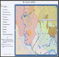 Figure 1. Screenshot of PST showing
feature categories
The PST application also allows non-GIS users to use geographical information in a user-friendly format. When complete, the PST may offer opportunities for the general public to comment on potential projects.
Q. Who initiated the PST and how are GIS data obtained?
A. SCDOT's Office of Planning and Environmental developed the concept of the PST from involvement with an FHWA-sponsored peer exchange on linking Planning and the National Environmental Policy Act. Six people were involved in the process. Currently, GIS data are obtained from various agencies and are updated on an annual basis.
Q. What transportation needs existed at SCDOT and why was GIS chosen as a tool to meet these needs?
A. The SCDOT Office of Planning and Environmental needed a way to evaluate projects that are placed on the long-range transportation plan list during the planning stage. To do this, the APPR was developed. The APPR incorporates GIS and other roadway data to assess impacts from a proposed project (Fig. 2). Once the APPR is completed, authorities will be able to analyze the costs and benefits of the proposed project.
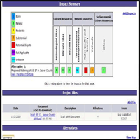 Figure 2. Screenshot of PST showing
project impact summary
The Office of Planning and Environmental has been using ArcGIS for the past several years. The increase in demand for GIS data, coupled with the desire to make GIS data more accessible, led the agency to spearhead the development of the PST application.
Q. How has the use of this GIS application met the needs of your agency?
A. The PST is not yet fully operational. However, once the application has been fully implemented, SCDOT feels that the PST should assist planners to identify impacts due to a potential project early on during the planning process.
Q. What are some of the specific benefits from use of the PST?
A. GIS data can help inform planners of the potential impacts and associated costs of a project during the planning stage. For example, the PST could identify a project that potentially impacts a historical landmark or a threatened or endangered species. Once these impacts are identified, planners and other agency staff can reassess the project before allocating additional funding to it (see Fig. 3). The PST allows partnering agencies and the general public to provide valuable input on projects by reviewing GIS data on potential projects. SCDOT staff, partnering agencies, and the general public have access to all GIS data in the PST.
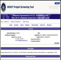 Figure 3. Screenshot of PST showing
project information
Q. Are there challenges in securing funding for use of the PST?
A. So far, there have not been difficulties in securing funds to initiate this effort.
Q. Are there future plans to change or modify how the PST is used?
A. The Office of Planning and Environmental will continue to make improvements to the PST application and is planning a second phase for modifying the PST. The second phase will allow SCDOT to analyze the PST's GIS data within a given right-of-way limit and provide more impact details on potential projects.
Q. What have been the critical lessons learned from the PST?
A. Identifying obstacles to a potential project early on through the use of GIS data has improved the decision-making process.
Editorial from Greg Ferrara, Institute for Transportation Research and Education at North Carolina State University
Where Should the North Carolina State Highway Patrol's (NCSHP) Motor Carrier Enforcement Focus Limited Resources?
The obvious answer is—where it is most effective!
Discovering the answer to this and other enforcement-related questions is one of a number of services that the Institute for Transportation Research and Education (ITRE) at North Carolina State University provides for the NCSHP's Motor Carrier Enforcement (MCE) group.
ITRE's GIS support for the MCE group is focused primarily on developing analysis and decision-support tools that MCE administrative staff and field troopers can use to more effectively target areas where safety and infrastructure preservation concerns are the greatest.
ITRE's Visual Analytics Modeling and Simulation (VAMS) group provides a wide variety of GIS products and services, including web application development, GIS analysis, hard-copy map production, derived layer creation, in-vehicle mapping, and training. A few of VAMS' current projects are highlighted below.
Truck Crash Geo-coding. The goal of this project is to create a yearly point layer of all commercial motor vehicle (CMV) crashes to assist with enforcement and CMV safety improvement efforts. Crash locations are mile-posted using a standardized combination of automatic and manual methods.
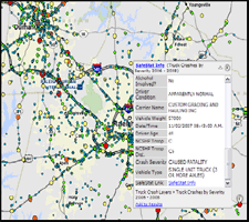 Figure 1. Screenshot of public site
showing CMV crashes.
Web Map Hosting. The goal of this project is to provide easily accessible, interactive maps for CMV enforcement decision-support needs. Two levels of access are available-public and secure. The public can view openly available CMV crash maps (Fig. 1). The secure site shows enforcement activities (e.g., driver/vehicle inspections, traffic enforcement, weight enforcement) relative to high crash areas and known heavy vehicle sources (e.g., manufacturing plants, landfills, quarries).
Hot Spot Analysis. The goal of this project is to identify areas where CMV crashes are clustered more frequently than would be expected from random chance (Fig. 2). Hot spot crash identification is also being developed to help avoid the tendency to mistake crash frequency with statistical crash risk.
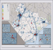 Figure 2. Hot spot crash analysis
for NCSHP Troop B.
Road Vulnerability Index (RVI). The goal of this project is to create a thematic GIS layer that shows where road infrastructure is most susceptible to damage from overweight vehicles (Fig. 3). The RVI integrates truck exposure (traffic and truck-specific counts) with roadway inventory data (e.g., pavement conditions, bridge conditions).
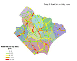 Figure 3. Draft RVI for NCSHP Troop B.
Where Oh Where? One way to gauge enforcement effectiveness is to ask: where are we presently conducting enforcement and where should we be conducting enforcement?
By overlaying GPS-captured enforcement events over crash density, we can start to visually detect useful patterns (Fig. 4). By adding hot spot density results to these visualizations, we add a level of statistical rigor to answer the question of "where should we be?" for CMV safety.
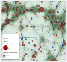 Figure 4. Enforcement activities
relative to truck crashes.
Lastly, integrating the RVI (once completed) with enforcement events will help increase troop enforcement effectiveness for protecting critical road infrastructure.
For more information on ITRE, the VAMS group, or VAMS projects, contact:
Greg Ferrara, GISP
Program Manager, VAMS Group
ITRE, North Carolina State University
Raleigh, NC 27695
gpferrar@ncsu.edu - (919) 515-8656
https://itre.ncsu.edu/
Other News
Recent Reports
Over the last few months, FHWA has released several reports related to applications of GIS for transportation decision-making purposes. These reports, listed below, are available along with many others at FHWA's GIS in Transportation website: www.gis.fhwa.dot.gov. Visit the site to learn more about these reports, as well as to submit information about your agency's transportation GIS applications.
Applications of 3D Visualization (July 2009) — This report provides a summary of a 1.5-day peer exchange held in Raleigh, NC in July 2009, focusing on select transportation agencies' applications of 3D visualization techniques. FHWA's Office of Interstate and Border Planning sponsored the peer exchange.
GIS Applications in Eco-Logical Grant Projects (July 2009) — This report provides a summary of a 1.5-day peer exchange held in Austin, TX in July 2009. The exchange convened select recipients of FHWA's first Eco-Logical grant and allowed recipients the opportunity to share information on the GIS activities implemented with grant support.
For More Information
For more information about this newsletter, please contact Mark Sarmiento, FHWA Office of Interstate and Border Planning, mark.sarmiento@dot.gov.


