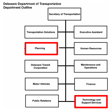
Figure 3: Organizational chart for the Delaware Department of Transportation
(adapted from organizational chart from DelDOT).
CONTACT: MATTHEW LAICK, (302) 760-2661
E-MAIL: MATTHEW.LAICK@STATE.DE.US
The implementation of geospatial technologies at Delaware DOT (DelDOT) has matured in response to a need for an efficient and cost-effective means of tracking transportation assets in Delaware. Since the early stages of developing the first geospatial applications at DelDOT, support for the use of geospatial data has been strong and apparent at all levels of the organization. Although the benefits of geospatial technologies have not been formally measured, an intuitive understanding of its usefulness has pervaded DelDOT business. Enthusiastic, purposeful champions from mid-level management have historically been able to communicate to others within the Department how geospatial data underlies a majority of the DOT's decisions.
The widespread support for using geospatial technologies for improved decision-making recently helped to enable DelDOT to develop and deploy a comprehensive, user-friendly, enterprise-wide GIS. Since its initial release in 2004, DelDOT's Information Network for Online Resource Mapping (INFORM) system has become the primary tool for mapping and viewing geospatial data within the Department. With INFORM, all staff can access geospatial data efficiently on their own desktops without needing additional software or training. The tool and how it supports DelDOT's unique business model is discussed in more detail below.
Geospatial activities at DelDOT, which are primarily funded by a capital budget, are spread throughout the entire organization. The Technology and Support Services Division is responsible for building DelDOT's geospatial applications, but several divisions within the Department have GIS specialists on staff and perform geospatial work (Figure 3). For example, both the Technology and Support Services Division and the Planning Division employ three GIS specialists, while several others are on staff in DOT divisions such as Transportation Assets and Engineering Systems. To varying degrees, most staff within the Department have become capable GIS users with the deployment of INFORM.
Although geospatial activities are distributed across divisional boundaries, divisions have worked to maintain close and fluid coordination. There is continued discussion among the various divisions' GIS specialists. This interaction is informal but steady and often offers opportunity for on-the-job training. The divisions have also worked to craft very specific job descriptions for GIS specialists, helping to ensure that skills are matched appropriately with divisions' business needs.

External Data-Sharing Opportunities
There is widespread cooperation for sharing geospatial data in Delaware. DelDOT both shares and obtains geospatial data with counterpart agencies with relative ease. This relationship is in part due to the evolution of Delaware's Data Mapping and Integration Library (DataMIL).9 Originally a pilot project for the USGS National Map, Delaware DataMIL, which provides an Internet Mapping Service for the State of Delaware, serves Delaware's Spatial Data Framework, or basic map datasets. State agencies, local and county governments, academic GIS users, and the private sector can build their own GIS data on the Framework. These datasets are considered the most current and up-to-date base map information available for Delaware; a data steward is identified to take ownership of each dataset and to publish the only "official" dataset for that part of the Framework. Datasets that change frequently are updated at least quarterly.
DelDOT's INFORM application is a GIS-enabled intranet portal that provides DelDOT employees with enterprise transportation data using a quick, efficient, and user-friendly interface. The system allows users with all levels of GIS expertise to quickly search, access, visualize, and analyze geospatial data essential for Delaware's transportation operations. As GeoDecisions, developer of the application, has explained, INFORM:
One of the most unique aspects of INFORM is that DelDOT's geospatial data are now found at one centralized location. This helps to eliminate data redundancy, providing the ability to meet many business needs with a single geospatial database.
Prior to this application, data were maintained in several locations, requiring DelDOT employees to have GIS software on their desktops to access spatial data and create maps. Now, all INFORM users have the ability to change data in the business applications they manage (e.g. the road inventory by the Planning Division). Any modifications that INFORM users make are immediately reflected as updates to the entire database. This ensures that everyone at DelDOT is working with the most accurate and current data.
With the INFORM application, DelDOT requires less GIS software — a significant cost savings to the Department. DelDOT GIS specialists can also now focus on data and applications development and maintenance rather than on having to address individual requests for maps, training, and other geospatial needs.
Reference