Webinar 46
Leveraging GIS for Right of Way (ROW):
Vermont Statewide Property Parcel Map
February 17, 2021
Summary of the Federal Highway Administration’s Quarterly Webinar
Background
The Federal Highway Administration (FHWA) promotes geographic information systems (GIS) as a means to more effectively manage and improve transportation systems. One of the ways that FHWA does this is through its GIS in Transportation program,1 which identifies timely and critical GIS issues and topics in transportation and connects transportation agencies with available resources and best practices. The webinar summarized here is part of a quarterly series organized through the GIS in Transportation program.
Johnathan Croft (Johnathan.Croft@vermont.gov) and Mary Haley (Mary.Haley@vermont.gov) of the Vermont Agency of Transportation (VTrans) presented on the efforts of VTrans to develop a statewide property parcel data layer. The webinar discussed the project from the initial enabling legislation; collaboration with agencies and departments; developing parcel standards; parcel data creation through vendors; issues experienced during the project; their “Grand List”; how this information is being used at VTrans; and transfer of the project to a program at the Vermont Center for Geographic Information (VCGI).
A recording of the webinar is available here.
History of Parcels in Vermont
Vermont is the second-largest State in New England and is composed of 255 towns, cities, gores, and a grant.2 There are 14 counties; however, governance is either at the State level or municipal level. Property boundaries and parceling of the land in Vermont has occurred for the past 275 years. Parcels are laid out using metes and bounds,3 with surveys in bearings and distance, and not through the Public Land Survey System.
The Grand List contains the assessor information on property owners, parcel size, improvements, and values provided from the municipalities to the Vermont Department of Taxes. Vermont has almost 300,000 statewide parcels that are landed—parcels that have acreage values greater than zero in the Grand List—and represent over 5.5 million acres, or just over 8,700 square miles. Until recently, there were no State requirements for surveys performed when parcel boundaries were altered and a survey is not required when properties are conveyed. Some municipalities do require surveys through their zoning ordinances but this is not universal across the State. Parcels have deeds on record in municipal offices but a survey of the property may not exist.
In 2015, Vermont determined that the condition of their parcel data was extremely low, an example of which is in figure 1. Parcel data developed at the municipal level remained incomplete; possibly out of date; in different formats, including some on paper, CADD, or GIS; and some even nonexistent. Some of the data was proprietary and not available for use. Much of the available data lacked the common statewide identifier preventing linkage of the data to the Grand List. In some cases, no parcel data existed at all, with some towns not having any tax maps or paper parcel maps. This created a spectrum of towns with relatively current GIS parcel data with good attribution, to towns with just deeds in the town records, with many of the 255 municipalities landing somewhere in between.
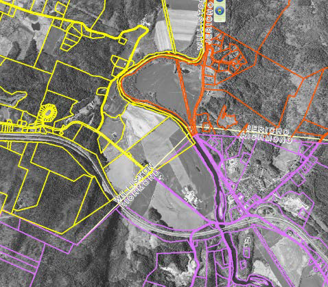
Figure 1. Map. Example of Jericho, Richmond, and Williston parcels and town boundaries not being seamless.
Development of the Statewide Property Parcel Data Layer
As early as 2013, discussions began on the development of a statewide parcel dataset and a group of stakeholders started to meet. This group included VTrans; staff from the VCGI (the statewide GIS data clearinghouse and organization that sets standards and policy for GIS); the Agency of Natural Resources; Department of Tax; Regional Planning Commissions; the Vermont Association of Listers and Appraisers (VALA); and the Vermont League of Cities and Towns (VLCT). This prompted VTrans to assess their parcel needs and determine whether they could secure funding. Before moving forward with the project, the IT Project Review Team at VTrans requested the development of a Return on Investment Study and Maintenance blueprint before giving the greenlight.
The Return on Investment Study and the Lifecycle and Maintenance Plan were essential to understanding the magnitude of the project, quantifying the value of the parcel data, and assessing a series of use cases from stakeholders. This process defined the current condition of the parcel data and a series of use cases from stakeholders identified through group meetings and individual interviews. The return on investment findings quantified the value of the parcel data and estimated the cost of the development project, as well as the cost of ongoing maintenance.
The Lifecycle and Maintenance Plan evaluated two options of how to keep the parcel data up to date and incorporate annual changes. The recommended approach required that municipalities and their contractors maintain the parcel data and coordinate with the Regional Planning Commissions to get the data posted to VCGI. The second approach was for the State to take on the maintenance of the parcels and do all updates in-house. The Return on Investment and Maintenance Plan provided a blueprint for a path forward, allowing VTrans to give the project the greenlight to proceed.
In 2015, the Legislature created the Statewide Property Parcel Mapping Program, due in part to the passing of enabling legislature, which provided oversight to the development of the statewide parcel data. Act 158 provides the authority for the development of the parcel data and the creation of the Property Parcel Data Advisory Board that was instrumental in providing guidance and collaboration between State Agencies.
The Statewide Property Parcel Mapping project started in 2017 through a project created by VTrans with funding through FHWA and matching funds provided through the agencies on the Parcel Advisory Board. Early in the project, the App Geo provided project management and worked as the liaison with the nine vendors. As the project developed, the Agency of Digital Services provided a project manager. The VCGI provided the coordination and outreach to the municipalities, including the development of a queue of towns for each of the development years. Thanks to a significant amount of coordination among agencies, vendors, and municipalities, this project was deemed a success. VTrans completed and delivered all parcels to the State by December 2019.
Once linked to the Grand List, there is enormous value to these data for right of way (ROW) and other efforts in the agency. These data include owner, acreage, and value information for parcels adjacent to the State’s highways, railroads, airports, and other infrastructure. The Statewide Property Parcel Map has many uses in VTrans, including:
- Emergency response work
- Corridor management
- Aid in update of town boundaries
- Property ownership patterns
- VTrans property resiliency planning
- Solar facility siting
- Hazard assessments
- Encroachment assessments of highway, rail, and aviation parcels
- Points of contact from adjoining landowners
- Quantification/assessment of the valuation of parcels owned by VTrans
- Ability to determine how many acres of land VTrans owns
- Provide support of the VTrans Project Delivery Process
- Offer automated ownership classification
One of the most important uses of the data occurred during Tropical Storm Irene in August of 2011. VTrans needed to make emergency repairs and it was not apparent whose properties were being affected. Due to major damage, VTrans needed to move equipment across private property and use private property as access. Not knowing ownership in advance caused VTrans a significant amount of follow-up work during the disaster.
Additionally, Vermont does not have a statewide town boundary survey and the current GIS data is an amalgam of data from the 1:24,000 United States Geological Survey (USGS) topographic maps, older parcel data, localized surveys between towns, and coarse approximations. The parcel data provides VTrans the opportunity to see commonalities and differences, aiding in the update of town boundaries.
Parcel data are fundamental to the ROW Data Life Cycle as well. The ROW process begins when transportation projects require acquisition of property outside the existing ROW. This is a huge investment of VTrans resources, including hundreds of labor hours per project across multiple sections. The statewide property parcel data map reduces some of these labor hours by identifying critical parcel data in one location, as seen in figure 2.
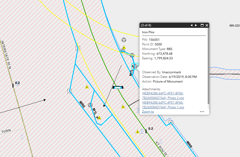
Figure 2. Map. ROW property data within the statewide data property parcel map.
VTrans concluded their presentation with a live demonstration of the statewide property parcel data map.
Lessons Learned
Through the development of the statewide property parcel data map, VTrans identified several lessons learned, including:
- For rural communities:
- Need to ensure good contact information and that it is kept up to date.
- Need to ensure schedules are flexible, as rural communities have very limited office hours and requirements.
- Need to manage good relationships with rural communities.
- Ensuring correct/best contacts:
- It is difficult to contact some towns so there is a need to maintain constant communications.
- Need to make sure vendors have the most up-to-date information.
- For town review:
- No requirement for sign off—concerned that with towns’ limited resources it would hold up timeline and burn budget.
- In Year 2 of the project, VTrans added a two-week review for towns. After Year 1, some towns expressed concern they had not seen the data prior to sign off.
Parcel Data Value and Conclusions
The Statewide Property Parcel Data project provides VTrans the ability to perform daily operations in a more efficient way through:
- Single authoritative source
- Comprehensive visualization
- Reduced labor costs
- A better understanding of parcels beyond the initial project extent
The Statewide Property Parcel Data project provides value beyond VTrans. The data is accessible to:
- Regional planning commissions
- Municipalities
- Agency of Natural Resources
- Land surveyors
- General public
Statewide Property Parcel Mapping Resources
Questions & Answers
Are the town boundaries legally defined by the parcels?
No, the town boundaries are defined by original town charters and any town boundary surveys that may have been put on file with the Vermont Secretary of State.
What are the legislative requirements for using Legal Land Surveyors? How does this accommodate that?
Land surveyors are licensed in Vermont with 26 VSA Chapter 45 providing details:
https://legislature.vermont.gov/statutes/chapter/26/045.
Property surveys are filed in town offices and have requirements defined in Title 27 of Vermont State Statutes in Chapter 17:
https://legislature.vermont.gov/statutes/chapter/27/017.
Who is the primary agency responsible for maintaining the statewide parcel data?
VCGI is now responsible for maintaining the statewide parcel data.
What was the overall development cost and were there multiple entities that contributed?
The overall development cost was approximately $1.5 million over the three years. VTrans was able to secure a project through FHWA to secure 80 percent of the funding. The parcel board members, composed of the State and municipalities, each contributed to a pool to fund the remainder.
Is State ROW now identified with a unique ID system?
VTrans pulls CAD file level names directly from the DGNs that are converted to GIS.
Return to top


