Webinar 29
Federal Highway Administration and the John A. Volpe National Transportation Systems Center Present on:
Uses of Geospatial Applications for Transportation Performance Management
June 2, 2016
Summary of the Federal Highway Administration’s Quarterly Webinar: Applications of Geospatial Technologies in Transportation
These notes provide a summary of the PowerPoint presentation discussed during the webinar and detail the question and answer session that followed the presentation.
The PowerPoint presentation will be available upon request from the webinar speaker, Mark Sarmiento (Mark.Sarmiento@dot.gov).
Presenters
- Mark Sarmiento
Federal Highway Administration, Office of Planning (HEPP), Washington, D.C.
Mark.Sarmiento@dot.gov
- Andrew Reovan
John A. Volpe National Transportation Systems Center (Volpe), Cambridge, MA
Andrew.Reovan@dot.gov
Participants
Approximately 51 participants attended the webinar.
Introduction
The GIS and Transportation Performance Management (TPM) webinar was the 29th in a quarterly series of Federal Highway Administration (FHWA)-sponsored webinars. The series deals with the application of geospatial information systems (GIS) and other geospatial technologies to transportation. The webinar featured a collaborative presentation by FHWA and the Volpe Center:
- FHWA and Volpe explore how State DOTs are developing programs around Transportation Performance Management (TPM), particularly as they prepare for requirements introduced by the Moving Ahead for Progress in the 21st Century (MAP-21) legislation. The presentation summarized the findings from interviews with four State DOTs and a series of case studies focusing on their experiences.
- The case studies will be published in a forthcoming report from FHWA, entitled “Uses of Geospatial Applications for Transportation Performance Management Case Studies of Select Transportation Agencies.”
Presentation: Uses of Geospatial Applications for Transportation Performance Management
Overview
Mark Sarmiento of FHWA provided an overview of the U.S. Department of Transportation’s efforts to introduce performance measures in transportation investment planning. Efforts to refocus on performance management, in their current form, were initiated with the Moving Ahead for Progress in the 21st Century Act (MAP-21) requirements and carried forward with the Fixing America’s Surface Transportation (FAST) Act. Since this shift, TPM has become an integral part of effective management of the transportation system. Through interviews with the South Carolina Department of Transportation (SCDOT), Ohio Department of Transportation (ODOT), Vermont Agency of Transportation (VTrans), and the Maryland Department of Transportation - State Highway Administration (MDOT-SHA), FHWA and Volpe highlighted examples of noteworthy practices, considering the advantages and disadvantages of different approaches in using GIS solutions for TPM and related efforts, and identifying strategies that use GIS to communicate the impacts of performance-based planning and operations at the State DOT level.
Background
MAP-21 introduced TPM as a core component and requirement of all surface transportation management. By focusing on national goals, increasing accountability, and improving transparency, TPM will improve decision-making through better informed planning and programming. The FAST Act, signed into law in December 2015, reinforces these goals and seeks to continue the efforts initiated under MAP-21. Based on the requirements introduced by MAP-21 and FAST, FHWA will continue to issue final regulations and guidance on performance management, conduct trainings and education on the new regulations, share best practices, and provide technical assistance. Because there have been few opportunities for transportation agencies to share information on how geospatial or GIS tools and applications can best support new performance management requirements, the case studies in this presentation and report aim to provide an opportunity for discussion.
Transportation Performance Management
TPM is a strategic approach that guides investment and policy decisions to achieve national performance goals. In general, TPM is a systematic, ongoing approach to transportation decision-making that involves:
- Identifying key information about the transportation system that allows decision-makers to better understand the consequences of their investment decisions;
- Improving communications between decision-makers, stakeholders, and the traveling public; and
- Ensuring that performance targets and measures are developed in cooperative partnerships and are based on data and objective information.
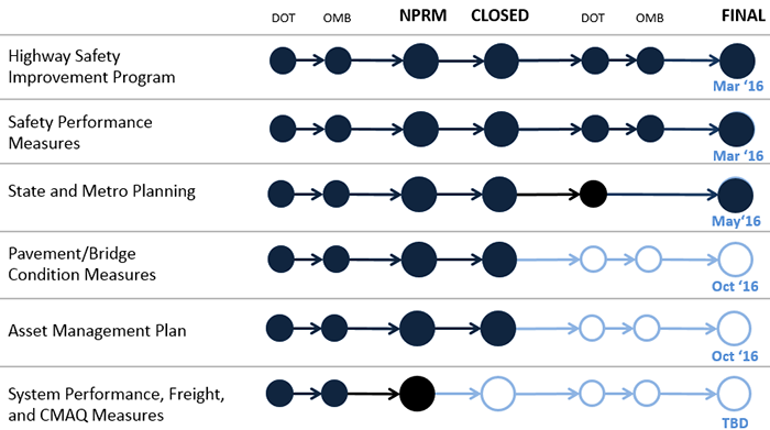
Figure 1 below describes the status of various rulemakings related to MAP-21 and TPM, as of this webinar. While FHWA implemented final rules for Highway Safety Improvement Program, Safety Performance Measures, and State and Metro Planning, the final rules are not yet in place for the Pavement/Bridge Condition Measures, Asset Management Plan, and System Performance, Freight, and Congestion Mitigation and Air Quality Improvement (CMAQ) Measures. As of the webinar, the comment period for the System Performance, Freight, and CMAQ measures was still open.
Figure 1. Implementation Status of TPM Rules
When developing the proposed performance measures, US DOT and FHWA considered a number of factors to select measures at the national level. Factors included: consistency and flexibility; the right balance of national measures across all areas; managing performance across jurisdictions and data types; and linking performance measures to investments and advancing technologies.
State-level Approaches to TPM
Each of the four peer agencies that FHWA and Volpe interviewed had varied approaches when incorporating TPM with geospatial/GIS tools and applications. Overall, all agencies applied a TPM approach to asset management, performance-based planning and programming (PBPP), and maintenance activities. In addition to these categories, one of the agencies interviewed, SHA, has begun to monitor performance of the roadway system in terms of mobility, freight movement, and similar measures. Given that final rules for system performance TPM have not yet been published, most agencies reported hesitancy in developing—or considering how to develop—geospatial/GIS tools that support these goals prior to seeing clear guidance from FHWA.
South Carolina Department of Transportation (SCDOT)
SCDOT uses an Integrated Transportation Management System (ITMS) and Project Programming system (P2S), seen in Figures 2 and 3 respectively, to monitor project programming and asset condition.
ITMS is a web-based geospatial tool that works with enterprise-level asset management and inventory. The tool integrates roadway inventory, construction management, maintenance management, safety, and bridge, pavement, traffic and financial systems.
Figure 2. SCDOT - Integrated Transportation Management System (ITMS)
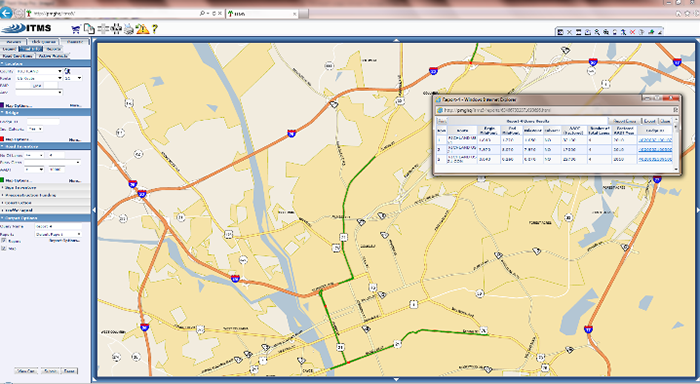
Figure 3 SCDOT - Project Programming System (P2S)
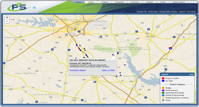
P2S is an internal project programming system that provides project management support in a geospatial database by managing and tracking project spending and progress. While the system currently only provides geospatial database support to project management tasks, it could be adapted or refined to support broader asset management efforts.
SCDOT hopes to build on the early successes of the two systems to move toward an integrated system for managing TPM reporting. Currently, the State is in the early stages of creating a risk-based Transportation Asset Management Plan (AMP). In doing so, SCDOT is assessing the current state of practice of what asset data is available, where data gaps exist, and how can these gaps be addressed.
Ohio Department of Transportation (ODOT)
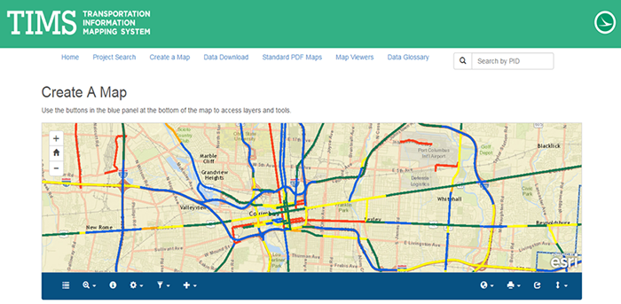
To address its TPM needs, the Ohio DOT uses a Transportation Information Mapping Systems (TIMS), seen in Figure 4. TIMS is a cloud-based, collaborative, and public-facing tool that is used by local transportation departments, MPOs, and State agencies. The tool integrates data from all division records and, similar to ITMS, TIMS provides an enterprise-level view of analysis. Ohio, unlike SCDOT, uses TIMS for both internal and external audiences, allowing external users such as MPOs to submit data to the DOT.
Figure 4. ODOT - Transportation Information Mapping System (TIMS)
ODOT’s Office of Technical Services (OTS), in coordination with the Office of Planning, plans to streamline ODOT’s transportation asset management (TAM) capabilities and reporting processes by enabling TIMS to render the results of asset queries and analysis. As a next step, OTS is working on capabilities to automatically generate a report on asset return on investment (ROI), based on existing asset condition and project funding data in the TIMS system.
ODOT’s use of performance management is primarily focused around asset condition at this time. TIMS is used to define the performance plan, identify what metrics are useful, aggregate information needed for investment decisions, and ultimately to inform stakeholders. As a next step, OTS is working on capabilities to automatically generate a report on asset return on investment (ROI), based on existing asset condition and project funding data in the TIMS system.
Vermont Agency of Transportation (VTrans)
The Vermont Agency of Transportation (VTrans) is in the middle stages of developing a software solution to support its TPM goals and objectives. VTrans’ tool, called VTransparency, is shown in Figure 5. VTransparency is a public-facing, web-based GIS tool that provides simple visual data on pavement, bridges, projects, and maintenance efforts, as well as links to data sources. So far, the tool has served as a great way for the agency to share information and answer specific customer questions, in turn generating more interest in sharing VTrans data and improving data quality.
Figure 5. VTrans - VTransparency
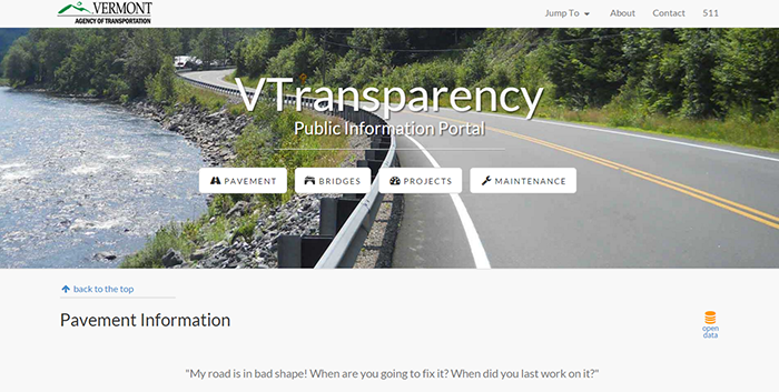
One of the goals that VTrans has with respect to asset performance is identifying and addressing asset needs. This is done by identifying asset condition levels, developing TAM programs for specific assets, and considering funding needed to sustain performance of the assets in the out years. By using VTransparency, the Agency hopes to connect asset management and investment level data and ultimately expand the breadth of content to better reflect the conversation about asset lifecycle and sustainable funding. Currently, VTrans monitors performance for areas such as project delivery time and engineering budget estimates. As a next step, the agency is expected to produce an internal-facing version of VTransparency, which will include more detailed data on engineering specification and could be used by other business units through connections with other tools.
Maryland State Highway Administration (SHA)
Since 2011, the Maryland State Highway Administration (SHA) has used an Enterprise GIS (eGIS) system to address internal geospatial data management needs. The current tool is shown in Figure 6. In an effort to facilitate collaboration between different offices and group, SHA has continued to develop data standards. With the same goal, the administration created the SHA Data Hub, which is a GIS-based centralized data repository, and established partnerships with other organizations such the University of Maryland Center for Advanced Transportation Technology (CATT). With CATT, SHA is Investigating improved ways to visualize/model traffic movement and measure mobility, safety performance, and other measures on the State’s highway network.
Figure 6. SHA - Enterprise GIS (eGIS)
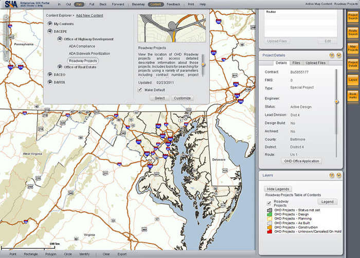
SHA has also been publishing an external-facing report on mobility within the State for the prior year, detailing peak and off-peak travel times and annual vehicle miles traveled (VMT) throughout the State. The mobility report tracks year-over-year performance on highways managed by SHA. SHA has also developed an internal-only Mobility Dashboard that is updated regularly with more current data, which identifies congestion trends and discusses SHA’s mobility policies, programs and projects, and the outcomes to the traveling public.
Finally, SHA is developing an Asset Management data warehouse and a MAP-21 dashboard. The data warehouse contains all of SHA’s assets and serves internal groups seeking information on projects and asset condition, as well as informs the traveling public of planned projects and improvements. The MAP-21 dashboard will focus on performance management in accordance with MAP-21, including mobility performance metrics and travel analysis models.
Themes & Highlights
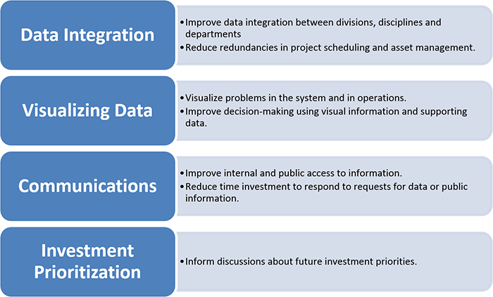
Overall, there are many benefits of using GIS or geospatial tools to support TPM reporting and monitoring efforts, as summarized in Figure 7. Among these benefits is the ability to represent investments and projects in a visual manner, which supports communications with both a technical and a non-technical audience. GIS can also lead to improved asset management practices, which in turn leads to a better understanding of each current or proposed project, and ultimately a more data-driven internal culture.
While there is a strong case for implementing GIS technologies in TPM efforts, State DOTs faced a number of challenges in developing their tools or practices. A common challenge from implementing a new technology is susceptibility to disruptions in implementation and usage from changes in leadership and staff. Another major challenge is finding adequate staff with proper training—inadequate staff resources can often derail new projects. On the other hand, collecting data itself can be very expensive. Because of cost or other more accepted practices, some internal cultures may also prove resistant to prioritizing data quality. Finally, many State DOTs were concerned that their own internal performance measures or requirements might not aligned with those of MAP-21 and the FAST Act.
Figure 7. Agency Motivations for Pursuing TPM
Lessons Learned
The agencies shared a number of lessons learned from their experiences implementing a geospatial or GIS system for TPM and asset management efforts. The first recommendation was the encouragement of an organizational culture of performance management. In the VTrans case study, the transportation agency found that dedicating staff to developing sustainable systems is critical to future success. SHA found that in changing the culture, it is key to have face time with leaders of all the teams (e.g. IT security and maintenance managers), in order to have clear and open communication. The way in which this might be done, SHA explained, is by first educating data owners and then working with the staff on defining the data including a well-established data dictionary. Finally, SCDOT found that implementing a performance management approach requires commitment across the agency.
Another common lesson for each agency was that in order to successfully implement TPM, there have to be dedicated resources for training and staff development to continually seek improvements in data quality. Per SCDOT’s experience, in order implement an effective asset management program, it is critical to treat all data as an asset. Similarly, ODOT explained it is beneficial to focus on existing working datasets and heavy users, instead of on specific applications or theories about what data is important. It also important to have succession plans in place to ensure smooth transitions in data governance and maintenance in the midst of staff turnover and retirements. Finally, VTrans explains that sharing data with stakeholders—MPOs, county engineers, and the public—substantially enhances data quality.
A last common lesson learned by each agency was that collaboration is key. It is crucial to TPM that agencies bring business units together to hear what data needs other units have and are interested exploring. According to ODOT, cross-disciplinary meetings can trigger new and/or original thinking, about users’ own data and also about what data might be desirable. In MDOT-SHA’s experience, in addition to agency staff, it is important to ensure partners and contractors are also aware of the importance of data governance to facilitate collaboration.
Return to top
Question and Answer Session: Volpe and FHWA
Is the SHA eGIS tool inward or outward facing? Also, is the application installed as software or is it web-based?
SHA’s eGIS tool is an inward facing software program that is used for addressing geospatial data management needs. One of the ways the SHA addresses outside parties is through its external-facing reports on mobility within the State, off-peak and peak travel times and annual vehicle miles traveled (VMT) throughout the State for the previous year. In order to facilitate access to each report, they are available for download at https://data-maryland.opendata.arcgis.com/pages/mdot.
How can someone download the webinar PowerPoint?
While the presentation is not online, anyone wishing to obtain a copy can email Mark.Sarmiento@dot.gov or Andrew.Reovan@dot.gov for a copy of the presentation. Until the final report is published, presentation materials cannot be posted online.
Return to top