WINTER 2012
A Newsletter from the Federal Highway Administration (FHWA)
www.gis.fhwa.dot.gov
A Look at the Michigan Department of Transportation's (MDOT) Lane Mile Inventory (LMI)
This edition's Q&A is with Cory Johnson and Kevin McKnight, Transportation Planners at MDOT. They discuss developing a GIS-centric LMI to collect and maintain MDOT's lane mile assets.
What is the history of the LMI?
MDOT, like many other DOTs, has struggled with the best method to collect and maintain a LMI. In the past, MDOT Central Maintenance would ask each of MDOT's seven regions to submit annual lane mile totals based on ongoing projects and estimated future construction. But without a system to accurately track these assets based on ongoing operations, it did not take long for numbers to stray from reality. Inaccuracies would force expensive system reviews, which sometimes contained inconsistencies themselves. Additionally, MDOT had multiple lane mile inventories that met slightly different business needs.
In 2009, MDOT leadership decided to search for a new solution that would function as the sole resource for lane miles paired with a process to govern the inventory. MDOT's Asset Management Division was tasked with developing a solution that would meet MDOT's needs to responsibly manage its 9,652 miles of state highway.
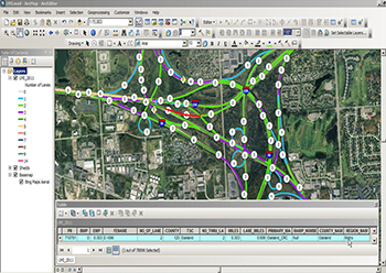 LMI displayed in ArcMap.
What is the purpose of the LMI?
The primary purpose of MDOT's LMI is to provide a critical centralized resource that supports MDOT in delivering annual maintenance and capital funds to MDOT regions (each of which receives a certain amount of maintenance funds per lane mile that it manages).
MDOT defines a lane mile as one mile of roadway that is designed as a driving lane. This straightforward definition was intended to provide a concise starting point and a clear methodology for completing field collection of inventory within one season. As the LMI continues to mature, the definition will be expanded to account for the complex nature of maintaining roadway networks.
Where are the data stored?
The foundation of the LMI is the Michigan Geographic Framework (MGF) centerline GIS file. The centerline file and linear referencing system are maintained by the Michigan Department of Technology, Management and Budget's Center for Shared Solutions (CSS), with funding and staff support provided from MDOT. MDOT's Asset Management Division staff teamed up with CSS to develop routines to migrate the data forward to match ongoing LRS updates as needed. Syncing the LMI with the MGF allows data to be centrally stored via ESRI's ArcGIS Server technology, thereby enabling broader accessibility.
How was the inventory completed?
The initial LMI was developed by modifying a copy of the MGF state highway centerline file, enabling it to host the required business data for the LMI. These required data included fields such as number of lanes, lane miles, maintenance responsibility, and a “field checked” date. Two staff members from the Asset Management Division then verified the accuracy of the GIS database in the field.
Once MDOT had established business logic for what constituted a lane and how information would be collected, it only needed a state vehicle, a laptop, ArcGIS Desktop, and a “hockey puck” GPS receiver. Using this equipment, the two-person crew was able to collect information on the entire lane mile system in one summer season.
How is the inventory maintained?
After MDOT completed its initial investment in collecting the entire system, the LMI entered an ongoing maintenance mode. During this phase, data were loaded into an ArcGIS server instance. In addition, an official contact person was established within each MDOT region. This contact is responsible for providing Asset Management Division staff with information about any ongoing operations that impact the total number of lane miles. This information provides the specific location data necessary for Asset Management staff to field verify each location and update the LMI as needed.
This “honest broker” role that the Asset Management Division played allows the LMI to function as one consistent resource for MDOT to use in its annual budgeting process.
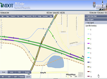 PR Finder web application showing the LMI.
How does staff access the LMI?
Staff members have several options for accessing the LMI to support their daily duties.
Provided they are on the state network, staff can access the LMI via any ESRI desktop GIS software. They can also view the inventory via the PR Finder web application. Staff can view the inventory in spreadsheet format broken down by geographic and maintenance responsibility summaries.
How has the use of the LMI benefitted MDOT?
The new LMI has provided a reliable process for updating MDOT's inventory, a central resource for information providing statewide consistency, and a means for governing the program. It has resulted in a better use of resources and staff time. It has also enabled MDOT to better compare costs per lane mile across the department and between contract agencies, leading to effective, data-driven business decisions.
The LMI will continue to serve as a model of how to develop a GIS-centric solution to meet the larger goals of an organization.
What were the critical success factors?
The most critical success factor was the fact that MDOT leadership mandated and supported changes to a long-standing program. Leadership also helped encourage staff members to adopt the new LMI solution. Another essential factor was the fact that Michigan had a robust GIS centerline file maintained through CSS. Finally, it was critical to develop partnerships between Asset Management, Central Maintenance, and regional staff.
What are future plans for the LMI?
The MDOT staff will continue to improve the LMI's ability to account for difficult issues such as parking, bike lanes, and highway shoulders. There are also ongoing efforts to create a work order-based web solution for the LMI that will take greater advantage of ArcGIS server technology and related map services. MDOT is laying the groundwork for implementing an enterprise asset management system; the LMI is one of over 60 databases already loaded into an ArcGIS server. In 2012, MDOT expects to make some critical decisions regarding enterprise asset management software. This will help to chart a solid and exciting course for the LMI and related asset inventories, while ensuring that the LMI remains as a critical resource in the budgeting process.
For more information on the LMI, please contact:
Cory Johnson
JohnsonC45@michigan.gov
Phone: 517-335-2931
Kevin McKnight
Mcknightk@michigan.gov
Phone: 517-241-4548
A GIS-Based Road Vulnerability Index (RVI)
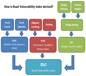 Contributors to the RVI.
Editorial from Greg Ferrara and Jeremy Scott, Institute for Transportation Research and Education (ITRE) at North Carolina State University (NCSU)
Overweight trucks damage roads and bridges.
This is particularly true when these trucks travel on roads that are not built to adequately handle their weight. Because the North Carolina State Highway Patrol's Motor Carrier Enforcement's (MCE) weight enforcement unit helps protect the State's Federally funded road and bridge infrastructure, it is important to identify road segments that are most susceptible to damage from overweight vehicles.
To this end, the Institute for Transportation Research and Education (ITRE) developed a quantitative RVI GIS layer. The RVI integrates truck exposure (truck counts) with roadway inventory data (pavement condition, bridge condition, etc.). By weighting these factors, vulnerability values can be assigned to road segments statewide.
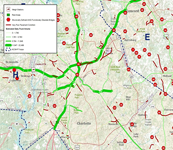 GIS layers displayed: poor condition roads and bridges along with
estimated truck volume.
The goal of the RVI is to give MCE planning staff a visual aid to help prioritize and target road segments that need weight enforcement attention. For example, while MCE planners can see poor pavement and bridge conditions as well as estimated truck volume segments on a map, it can be difficult to prioritize specific road segments for weight enforcement activities.
By combining truck volumes, pavement condition, and bridge condition into a single layer, MCE planners can easily visualize where road segments are most vulnerable to weight issues. With weight enforcement event locations added, enforcement personnel can determine if weight enforcement activity is properly targeting such “vulnerable” segments.
The RVI helps simplify and focus MCE's mobile weight enforcement efforts since it only shows vulnerable road segments on the map.
ITRE is also working closely with the North Carolina Department of Transportation's Pavement Management and Traffic Survey Units to fully implement the GIS-based RVI and potentially extend it for use in roadway maintenance and operations.
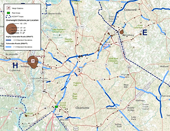 Draft RVI overlaid on overweight citations per location.
Currently, the RVI is published internally for use in MCE planning operations. However, RVI methodology and formulas are freely available to the public via the RVI page listed below. Additionally, the RVI GIS layer is available by request as are the steps used to create it.
Visit ITRE's Commercial Vehicle Enforcement Resource Lab (coverlab.org/) for additional details.
For more information, you may also contact:
Jeremy Scott
Jscott@ncsu.edu
Phone: 919-515-7877
Greg Ferrara, GISP
Gpferrar@ncsu.edu
Phone: 919-515-8656
itre.ncsu.edu
Other News
Website Update
FHWA has updated the GIS in Transportation website at www.gis.fhwa.dot.gov. The website offers information on GIS events, industry news, and innovative GIS applications from around the country, as well as the FHWA GIS in Transportation quarterly webcasts and newsletters.
Reports
FHWA produces reports on uses of GIS tools and applications to support transportation decision-making. Most recently, FHWA released three peer exchange reports that detail lessons learned and best practices in transportation agencies' uses of GIS to address highway safety, climate change, and livability.
These report and others are available at www.gis.fhwa.dot.gov. Please visit the site to learn more or to submit information about your agency's transportation GIS applications.
Webinars
FHWA is sponsoring a quarterly GIS webinar series that provide information about current GIS efforts, applications, and initiatives. Planners from State Departments of Transportation (DOTs), Metropolitan Planning Organizations (MPOs), and others are particularly encouraged to attend.
For More Information
For more information about this newsletter, please contact Mark Sarmiento, FHWA Office of Planning, at mark.sarmiento@dot.gov.