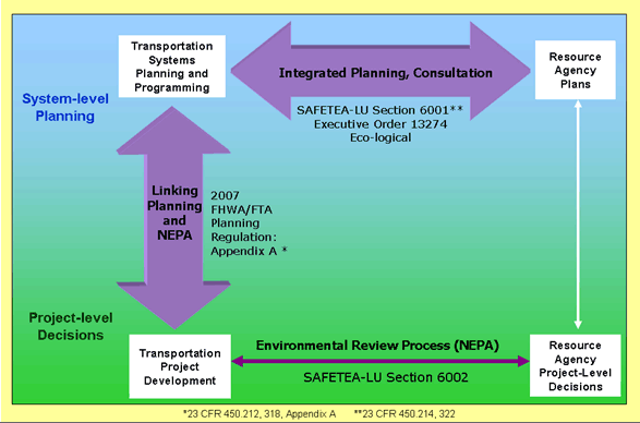
Figure 1: Planning and Environment Linkages in Decisionmaking Processes
Welcome and Introductions
Mark Sarmiento, FHWA Office of Interstate and Border Planning and Carson Poe, USDOT Volpe Center
Participating via teleconference, Mr. Sarmiento began the peer exchange by introducing the agenda and recapping the purpose of the meeting. Questions the exchange was intended to address include:
The various GIS–related activities that FHWA's Office of Interstate and Border Planning has supported over recent years were also described during the introductory discussion. Some of these activities have been:
To conclude, Mr. Sarmiento presented several graphs illustrating the results from the American Association of State Highway and Transportation Officials' (AASHTO) previous annual surveys on GIS and transportation. By describing some of the recent national trends, peer exchange participants were given an opportunity to understand where the GIS for PEL discussion falls into the broader context of GIS implementation across the current transportation enterprise.
Planning and Environment Linkages (PEL)
Gina Barberio, USDOT Volpe Center
PEL is both an approach to transportation decisionmaking and a FHWA program that considers environmental, community, and economic goals early in transportation planning and carries them through project development, design, construction, and maintenance. The purpose of PEL is to help agencies streamline transportation decisionmaking and improve coordination among transportation and resource agency decisions to develop projects that best serve a community's transportation needs and support other quality of life goals.
Figure 1 below depicts a continuum between systems–level planning (top) and project-level decisions (bottom) at transportation agencies (left) and resource agencies (right). Currently, there is coordination between transportation and resource agencies at the project level under NEPA, including environmental analysis documentation, consultations (such as for the Endangered Species Act), and permitting (such as for the Clean Water Act). PEL strives to strengthen the links between transportation and resource agency systems planning and between transportation agency planning and project development, depicted by the wide purple arrows in Figure 1. Listed adjacent to the arrows are the transportation laws, regulations, and guidance that guide these efforts
PEL–related activities can benefit the project development process through:
In addition, some PEL practices are now required by law. For example, SAFETEA-LU requires transportation agencies to consult with state and local resource agencies to compare transportation plans with conservation plans, maps, and inventories of natural and historic resources. Transportation agencies are also required to identify potential environmental mitigation opportunities.
Figure 1: Planning and Environment Linkages in Decisionmaking Processes
Agencies can use GIS to implement and improve the PEL approach by:
Specifically, agencies can use GIS in PEL implementation to:
Figure 2 shows an example of how agencies can use GIS to conduct environmental analyses earlier in planning. The Houston–Galveston Area Council overlaid sensitive resources on proposed transportation projects in long–range planning using the GIS Screening Tool. Transportation agencies can use similar visualization techniques to identify and discuss potential areas of concern in proposed projects. With the right tools and coordination among agencies, agencies can also narrow the list of alternatives of a proposed project before initiating the NEPA process.
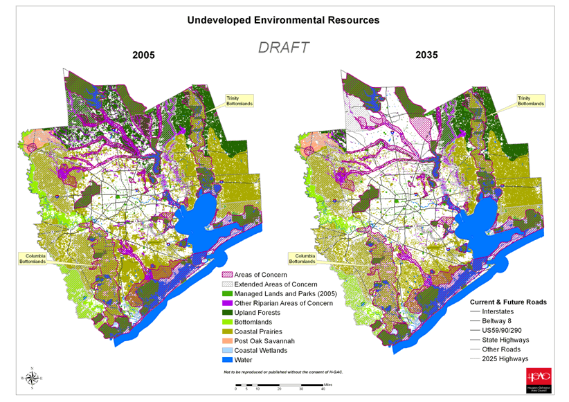
Figure 2: Example of Houston-Galveston Area Council output using the GIS Screening Tool.
As part of the PEL program, FHWA has developed several initiatives to inform agencies on how to integrate PEL into transportation decisionmaking processes. Activities include:
Over the next year, the PEL program with work more closely with the following interagency efforts that also promote PEL concepts:
For more information on PEL, please contact:
Diane Turchetta
FHWA Office of Planning
Phone: (202) 493-0158
Email: diane.turchetta@dot.gov
Michael Culp
FHWA Office of Project Development and Environmental Review
Phone: (202) 366-9229
Email: michael.culp@dot.gov
Comments, Questions, and Answers
State DOT Roundtable
All Participants – Rachael Barolsky (USDOT Volpe Center) facilitated
In order to introduce participants to each other as well as to give an overview of their respective DOT's GIS for PEL activities, a brief roundtable discussion was held. Along with the results of a questionnaire distributed in advance of the peer exchange to guide the discussion 4, the discussion was guided by the following questions:
In response, participants broadly outlined what interested them about the planned peer exchange agenda topics and how their own DOT's experience related and could contribute to the dialogue. Because Florida DOT and Oregon DOT gave in depth presentations later during the exchange, information from their respective roundtable overviews are incorporated in this document as part of the "Demonstrations and Presentations" section.
Idaho DOT
Liza Fox
Idaho Transportation Department (ITD) has moved back and forth between having a centralized and decentralized GIS program. This has been in part due to turnover in executive level management. When ITD's GIS activities were decentralized, managers faced difficulties in properly utilizing their GIS staff. Now, as ITD's GIS activities are becoming centralized, GIS staff are adapting to the changing culture. The links that GIS can support in PEL seems to be "low–hanging fruit" behind which a GIS program could be organized.
The ITD is also coordinating with Washington DOT (WSDOT) on a pooled fund study to develop a translation tool that will help migrate local inventory data into a statewide database. The end result will be a "smart" data set that allows users to do more analysis than simply edge matching. Before integrating the maps on a large scale, more local data are needed.
Questions from ITD to answer during the peer exchange:
South Carolina DOT
Mark Pleasant and Randy Williamson
Several years ago, South Carolina DOT (SCDOT) environmental staff were part of a pre-construction engineering group. More recently, environmental activities have been moved under the planning division, which has encouraged greater communication among planning and environmental staff, as well as with other agencies. SCDOT now funds liaison positions at the US Fish and Wildlife Service (FWS), US Army Corps of Engineers (USACE), State Historic Preservation Office (SHPO), Department of Natural Resources (DNR), and other agencies.
As environmental and planning activities became more integrated at SCDOT, GIS began playing an important role, and it is now being used to help screen projects during long–range planning. The agency currently uses its Advanced Project Planning Report (APPR) as a pre-environmental process document that is based on the GIS screening process. Resource agencies took the lead in establishing the APPR as a communication and decisionmaking tool. New projects must go through an APPR review before they enter the Statewide Transportation Improvement Program (STIP).
One of the challenges in implementing GIS at SCDOT has been the fragmented nature of its use. SCDOT has a GIS department with a centralized GIS, but planning and environment have developed separate GIS to meet their needs.
Questions from SCDOT to answer during the peer exchange:
Tennessee DOT
Kim McDonough and Jeanne Stevens
TDOT has a similar reporting process as South Carolina, but uses less GIS. TDOT is developing an extensive statewide environmental management system called SEMS (Statewide Environmental Management System). Data are not yet shared, as TDOT is waiting for the document sharing system to be completed.
TDOT would like to resolve how to overlay roads on buffers with "fuzzy boundaries" around sensitive resources. This would provide for the "correct" interpretation of the data, enabling better decisions. A challenge has been that resource agencies often provide general comments to TDOT but are reluctant to give site–specific comments during long–range planning. Since the agencies often face limited funding and staffing, it is sometimes difficult to plug them into the DOT's GIS applications, data, and analysis processes.
Questions from TDOT to answer during the peer exchange:
Washington DOT
Cliff Hall
WSDOT developed a centralized database, called the Environmental GIS Workbench, which includes data from Federal, state and other agencies. Data are used to flag likely environmental issues affecting project–level planning throughout the state. Currently, WSDOT is determining how GIS activities can be best married with planning activities. The Department's GIS staff are working closing with planning staff to know and understand what the data requirements are.
Questions from WSDOT to answer during the peer exchange:
Demonstrations and Presentations
All Participants
Oregon DOT
Milton Hill
Building off the existing Salmon Resource–Sensitive Area Mapping (SR–SAM) resource inventory for maintenance activities on road corridors, ODOT developed an Environmental Data Management System (EDMS). The EDMS is a collection of projects that focus on the dispersion of environmental spatial data to agency staff. In developing the system, ODOT took an adaptive management approach: it tests and adapts various tools to meet the Department's evolving business process needs. Some examples of current activities include:
Challenges:
The DOT data set is separate from resource agencies' data sets, so there is duplication of effort. Unlike the past, resource agencies now have substantially better data in GIS format. Now ODOT can update data with existing resource agency information and is beginning to do so using live feeds from resource agencies. The internal DOT server stores shape files for agency–wide central repository, however, only parts of the DOT know that this system exists. Different offices at the DOT use different GIS tools, and there is not a lot of interaction among offices regarding available tools. In addition, there are concerns about data security and sharing with resource agencies to ensure confidentiality of data, such as with State Historic Preservation Office.
Comments, Questions, and Answers
Florida DOT
Buddy Cunill and Pete McGilvray
Background
Prior to enactment of the Transportation Equity Act for the 21st Century (TEA-21), FDOT was faced with three major challenges:
Through the Efficient Transportation Decision Making (ETDM) process, FDOT sought to restructure its transportation decisionmaking process in two ways – through technology and through agreements with resource agencies. FDOT realized early in development of ETDM that developing technology was not enough. FDOT needed consensus among agencies and substantial involvement of stakeholders to ensure agencies would contribute data and update the data to a centralized GIS.
FDOT engages resource agencies early in planning and keeps them involved throughout the entire planning and project development processes. FDOT funds 36 positions at resource agencies. Through the Environmental Screening Tool (EST), project information is carried from planning to project development. ETDM has an Internet-accessible interactive database tool that allows the public greater access to information and the ability to comment on areas of concern.
FDOT was able to achieve this substantial change through strong leadership at the DOT and with funding from FHWA. In 1999, FDOT held an executive summit with resource agencies to get proper "buy–in" of process changes. Agencies signed a Memorandum of Understanding (MOU), then FDOT worked with agencies individually to develop Memoranda of Agreement (MOA) and agency operating agreements specifically tailored to each agency's process. Metropolitan Planning Organizations (MPO) did not sign the MOU, rather MPOs have incorporated ETDM into their business practices.
Data Management
Federal, state, and local agencies provide data to ETDM. Data are not reconciled among agencies, even if two agencies provide data on the same resource. This allows all agencies to use their data for analyses at all points of the decisionmaking process, and gives agencies greater ownership in both the tools and the process. FDOT benefits by channeling its time and resources away from detailed data reconciliation and towards higher level coordination among agencies.
FDOT asks each agency what data they want to see when they conduct analyses, as well as information on the buffers each agency uses to analyze areas around various resources. More data are not necessarily better, which is a common misconception. The only data requirements for ETDM are that agencies have meta data and that the contributing data source requests that data are stored in the database. As agencies collect new data, FDOT is now making data formatting requirements for new data, now that agencies have buy-in into the ETDM process.
Agencies do not think of ETDM as a DOT tool; it is an interagency data sharing system. Each resource agency has a different data update cycle, which is coordinated through the database. The database sends automated requests for agency updates based on that agency's update schedule. Agencies update data through a FTP site.
Different resource agencies can run separate analyses based on the criteria they use to make decisions. Resource agencies determine the Degree of Effect identified in a buffer and intersect query based on their jurisdiction, and input this determination into the EST. If there is a dispute, the EST will ask related questions to the reviewing agency, such as inputting appropriate statutes. If no dispute is recorded, this is also documented in the system.
Legal Sufficiency
Rather than have resource agencies and local entities update data directly to the system, FDOT keeps a copy of the most recent data provided to ETDM. As a project enters certain stages of planning, FDOT can take a "snapshot" of the conditions and data upon which decisions are made throughout the project. The snapshot includes all analyses conducted and all data used in decisionmaking. This supports the Federal Record such that decisions made in the past for a particular project can stand up in court based on information known at a particular point in time, not based on future changes to the resource in question. This snapshot also allows agencies to track changes in a project over time. If a project is in an active review period, data are not updated for that project until the review period has passed.
Resource Agency Involvement, Public Involvement, Security and Confidentiality
Every FDOT district has an associated Environmental Technical Advisory Team (ETAT) that is comprised of representatives from 23 resource agencies. One ETAT member acts as a representative for each resource agency and can update data to the ETDM database for the entire agency. All data updates and comments are, therefore, vetted through one "data custodian", so the system will not receive information from different offices within the same agency. Other staff within an agency have read capabilities to the system, so they can check for incorrect or outdated information and inform the data custodian.
The EST has two versions–a public access site with a simple interface, and a secure website for confidential data, analyses, and decisions. The secure site is considered "draft," while the public site contains "final" information. The secure site contains data purchased from private sources, such as information on all local roads in the state, as well as sensitive data, such as locations of threatened and endangered species or historic properties. All other resource data is available on the public site. All agreements with all agencies are also posted on the public site. ETDM developers worked with the FDOT legal team to develop disclaimers on each site.
Stakeholders receive notifications based on their involvement in the process as decisionmakers or interested parties. Stakeholders can choose how they are notified, such as for particular projects or concerning certain issues. ETDM does not replace other public involvement mechanisms; it only adds to the process. Each ETAT has a Community Liaison Coordinator to aid public involvement in each district. FDOT also hosts public meetings and posts information on the FDOT and ETDM websites. The public can provide comments through the public website, which are provided as a summary in project reporting.
During project reviews, reviewers can access maps and other project-specific information on the secure website. The site has an interactive checkbox that is relevant to the review requirements of each agency. For example, the lead agency can choose to accept or not accept the project purpose and need, while a participating agency can choose understand or do not understand. Reviewers can only access and influence project comments related to their authority within the review process. All agencies involved in ETDM have agreed to a 45–day review and comment period for planning and project level reviews.
Once resource agency project reviews have been submitted, FDOT can review concerns on a particular project or issue. FDOT then responds to the project or issue in a summary Degree of Effect box on the secure site to track both resource agency comments and FDOT responses. These data are automatically entered into the document tracking system once comments are considered official.
Resource agencies can get involved in developing the project purpose and need and conducting alternatives analyses in programming, long before the environmental review process begins. By completing much of the work prior to NEPA, agencies can save time and resources during environmental reviews by carrying these analyses and decisions into the NEPA process.
Resource agencies do not issue permits during programming and planning. Instead, agencies provide information on critical potential permitting issues. ETDM allows agencies to perform the appropriate level of screening at the appropriate time. Long-range planning analyses are separate from programming and project level planning.
Benefits and Costs
ETDM program development and support cost $9.1 million from 2000-2007. Resource agencies provided in-kind support (staffing, training, equipment, etc.) of $3.7 million. Since its inception in 2004, ETDM has saved an estimated $15.2 million and 38 labor years of effort. The EST and interagency coordination have also allowed FDOT to reduce the risk of cancelling major high profile projects.
The keys to ETDM's success are dedicated IT staff and funded positions with resource agencies. In addition, getting buy-in from agencies is critical. ETDM is not a DOT application; rather it is an agency coordination application. FDOT built ETDM based on resource agency needs for data, analysis, and reporting. Resource agencies conduct analyses of proposed transportation projects based on their areas of expertise–not just during the NEPA process, but throughout transportation decisionmaking. Resource agencies have more ownership of the process, and FDOT does not need to interpret resource agency data, which reduces duplication of effort.
Challenges
FDOT faces challenges common to all agencies and states, including gaps in data and constraints in both time and funding. It is an ongoing challenge to work with resource agencies to ensure their programmatic initiatives are part of the transportation decisionmaking process early on, so that stakeholders are aware of new initiatives and they are properly incorporated into the ETDM process. As ETDM grows, FDOT would like to incorporate new concepts and tools, such as performance management.
FDOT conducts an annual survey with districts and hosts an annual ETAT summer session to identify data gaps, analysis needs, and value added to projects and decisions. FDOT uses the feedback to further improve its tools and process. Technology and process development requires an iterative approach, with discussion of the varying needs among different offices (executive level management, planners, environmental staff, etc.)
Comments, Questions, and Answers
Participant Discussions
All Participants – Rachael Barolsky (USDOT Volpe Center) facilitated
Topic 1: Identifying Existing Transportation and Environmental GIS data; and
Topic 2: GIS Coordination with Resource Agencies
After hearing earlier presentations and discussions, the facilitator and participants agreed that in order to be most successful in accessing the best available transportation and environmental GIS data, transportation agencies should coordinate as much as possible with resource agencies. With this understanding, participants merged the first two of the planned three open-ended discussion topics to complete day two of the peer exchange. Salient comments from the discussions include:
Facilitator: Does your DOT know what to ask from resource agencies?
Facilitator: Are there issues getting buy–in from leadership and the rest of the DOT? How can change management be promoted?
In the first day of the peer exchange, participants discussed how transportation agencies can coordinate with resource agencies both to access GIS data and involve resources agencies early in the planning process. In particular, participants related the discussion to how agencies can use GIS and other geospatial applications to conduct environmental analyses in the planning process. During the third open-ended discussion, participants built on lessons learned in day 1 by discussing how to carry planning level analyses and decisions into the project development and environmental review process so agencies can implement PEL and streamline decisionmaking. Comments are summarized below, with questions following.
Question: An area of GIS that is often overlooked is
pre–classification to identify the level of sensitivity or impact of an
area. Instead of overlay analysis, overlay a grid of sensitivity to
find the path of least resistance. It requires more work upfront but it
is easier to analyze later. Has anyone used this technique?
Response: Yes, FDOT uses a statewide grid for wildlife, which is an
integrated grid of resources rather than 15 separate layers of data.
Initially, agencies were reluctant to use the ETDM GIS. Now, agencies
want an online system for all their projects. They are also using ETDM
for ancillary (non-transportation related) benefits to their programs.
Agencies realize the value of a clearinghouse where the same data are
commonly accessed and viewed. 525 data sets are online and available
for download, as long as the data are not sensitive or owned by private
organizations. With ETDM, responsibility sits with the owners of the
data to conduct their own analyses and interpret their data. The DOT
can then do a reality check to see if the results make sense, rather
than try to analyze (and potentially misinterpret) the resource agency
data. Of course, it requires many meetings and discussions with
agencies to get everyone on the same page. Figure out the process
first; then worry about the GIS.
Question: Will resource agencies want to take on this responsibility?
Response: By analyzing and interpreting their own data from the
beginning of the planning process, resource agencies have a greater
opportunity to protect the resources for which they are responsible. It
is to resource agencies' advantage to get involved in this way. The DOT
wants to facilitate resource agency needs, but it will not tell
resources agencies how to do their jobs. Resource agencies identify the
data sets. FDOT and resource agencies talk through the questions the
resource agencies want to ask about sensitive resources near a project.
They can talk through issues with the help of GIS maps and data sets,
and then agree on a process.
Question: Do the FDOT agreements apply to all projects?
Response: Agreements with resource agencies are made on a programmatic
level rather than at a project level, so process agreements apply to
all projects. At the project level, however, agencies can modify their
analyses slightly based on specific project needs.
Question: Does FDOT have performance data on a reduction in the number of lawsuits?
Response: Lawsuits come from decisions, not from process, though FDOT
has not had many lawsuits. ETDM gives FDOT a better chance to avoid
many challenges because all agencies are involved, and the entire
decisionmaking process is documented. The DOT will not be able to
eliminate lawsuits; however it can make lawsuits more defendable in
court through a documented process. Automated notifications can be
tracked since they stored in the database. If an agency does not
provide a comment, this is also documented in the system. Agencies
receive quarterly updates of notification summaries, such as the number
of projects on which agencies were notified and the number of response
from the agency.
For the I–73 project from Michigan to Myrtle Beach, South Carolina, SCDOT outsourced its GIS analyses. A corridor analysis tool was developed to compile information from 21 agencies, including data from resource agencies, counties, and cities. There were 877 GIS layers, including environmental, roadway, social, economic, and geographic layers that were pared down to 52 useful data layers. The system created alignments based on overlaid resources, which saved a lot of time. The Final Environmental Impact Statement (EIS) for the 47–mile Interstate only took two and a half years to complete; the Record of Decision took three years. In the future, there may be funding and education issues to fully integrate planning and environment, but DOT staff are interested and will share ideas with the executive level. As leadership make PEL a greater priority, staff will also work together in a more integrated way.
Legislatively mandated project prioritization now requires SCDOT planning and environmental staff to work together. Staff must review nine prioritization criteria for each project. All projects are scored and ranked during a meeting with Planning, Environment, GIS, etc. When environmental staff were moved out of engineering and into the planning division, staff could expand their analyses with less influence of funding and having to push project through. South Carolina is in a good position for change to incorporate PEL into its processes.