GIS APPLICATIONS IN ECO-LOGICAL GRANT PROJECTS
Peer Exchange Summary Report
Austin, TX
July 22-23, 2009
Prepared for:
Office of Interstate and Border Planning and
Office of Project Development and Environmental Review
Federal Highway Administration
U.S. Department of Transportation
![]()
Prepared by:
Multimodal Systems Research and Analysis
John A. Volpe National Transportation Systems Center
Research and Innovative Technology Administration
U.S. Department of Transportation
![]()
Table of Contents
I. SUMMARYII. BACKGROUND ON ECO-LOGICAL
III. PRESENTATIONS AND DISCUSSION
Welcome, Introductions, and OverviewIV. ROUNDTABLE DISCUSSION AND OBSERVATIONS
Demonstrations and Presentations
Capital Area Council of Governments (CAPCOG)
Houston-Galveston Area Council (H-GAC)
North Central Texas Council of Governments (NCTCOG)
U.S. Environmental Protection Agency (EPA) Region 6
Mid-America Regional Council (MARC)
Tri-County Regional Planning Commission (TCRPC)
Oregon State University (OSU)
Audubon Society Of New Hampshire
APPENDIX A. Participants
APPENDIX B. Agenda
I. SUMMARY
On August 22-23, 2009, the Federal Highway Administration's (FHWA) Office of Interstate and Border Planning and Office of Project Development and Environmental Review sponsored a 1.5-day peer exchange to convene recipients of "Eco-Logical" grants whose funded projects related to geographic information systems (GIS). The Capital Area Council of Governments (CAPCOG) in Austin, Texas hosted the peer exchange, and participants included staff from the U.S. Environmental Protection Agency (EPA) Region 6, Envision Central Texas, FHWA, Houston-Galveston Area Council, Mid-America Regional Council, New Hampshire Audubon Society, North Central Texas Council of Governments (NCTCOG), Oregon State University, Tri-County Regional Planning Commission, the Trust for Public Land, the U.S. DOT Volpe National Transportation Systems Center, and The Wetlands Conservancy.1
The purpose of the peer exchange was to allow grant recipients the opportunity to share information on and learn about the various GIS activities implemented with support from FWHA's first Eco-Logical grant cycle. Lessons learned and challenges faced were also discussed. This report summarizes the presentations given and ensuing discussions. Comments, questions, and answers from participants' presentation sessions follow the presentation overviews. It is expected that this document will be a resource for other transportation agencies seeking to learn more about uses of GIS to support the implementation of an ecosystem approach to transportation project development.
II. BACKGROUND ON ECO-LOGICAL
FHWA's publication Eco-Logical: An Ecosystem Approach to Developing Infrastructure Projects (Eco-Logical),2 which a team of representatives from eight Federal agencies and four State Departments of Transportation (DOTs) developed, articulates a vision of how infrastructure development and ecosystem conservation can be integrated to harmonize economic, environmental, and social needs and objectives. In 2007, FHWA's Office of Planning, Environment, and Realty (HEP) established a grant program to test the concepts presented in Eco-Logical. Receiving 40 applications from across the country, FHWA funded 14 cooperative agreements and one interagency agreement totaling approximately $1.4 million. Grant recipients included State and local DOTs, Federal and State resource agencies, Metropolitan Planning Organizations (MPOs), local governments, non-governmental organizations, and one university.
The pilot projects receiving grants support the new planning provisions and environmental review process as described in the Safe, Accountable, Flexible, Efficient Transportation Equity Act: A Legacy for Users (SAFETEA-LU) and Executive Order 13274: Environmental Stewardship and Transportation Infrastructure Project Reviews. FHWA HEP and Resource Center staff administer these projects.
III. PRESENTATIONS AND DISCUSSION
Welcome, Introductions, and Overview
Mark Sarmiento, FHWA Headquarters
Bethaney Bacher-Gresock, FHWA Headquarters
Jan Brown, FHWA Texas Division Administrator
Mr. Sarmiento began the peer exchange by describing FHWA's ongoing interest in promoting geospatial technologies. In FHWA's view, geospatial technologies can significantly contribute to making improved transportation decisions. Over the last several years, FHWA's Office of Interstate and Border Planning has sponsored a number of peer exchange events on a variety of topics. The peer exchanges were recommended from an FHWA's executive scan on geospatial technology in 2006. Summary reports for the scan and the peer exchanges can be found on FHWA's GIS in Transportation website: www.gis.fhwa.dot.gov. Other FHWA outreach activities on geospatial technologies include quarterly newsletters, webcasts, research studies, and support of the Association of American State Highway Transportation Officials' annual GIS-T symposium.
Ms. Brown, one of the founders of FHWA's Eco-Logical effort, discussed the impetus for assembling an interagency team to draft the Eco-Logical document. From time to time, State DOTs have expressed frustration in the length of time it takes to get through the environmental process for proposed transportation projects. In some cases, the issues causing delays are similar and/or repetitive. To address this problem, Ms. Brown and her counterparts decided to try and agree on an approach that would maximize the positive natural resource outcomes in a region using the often funding and staff time constraints State DOTs face. The resulting process, which eight Federal agencies endorsed after two years of collaboration, is outlined in Eco-Logical.
Ms. Bacher-Gresock, FHWA Headquarters lead contact for the Eco-Logical grant program, welcomed participants and posed questions for them to consider during the peer exchange. Some questions to be addressed included:
- How has the actual implementation of Eco-Logical gone? Who has done what?
- Was all the information needed available?
- What has been learned?
- What have been the barriers to implementation?
Demonstrations and Presentations
Capital Area Council of Governments (CAPCOG)
Sean Moran and Lori Olson
CAPCOG was organized in 1970 to serve local governments in a ten-county region around Austin, Texas. Acting primarily as an advocate, planner, and coordinator of various regional initiatives, CAPCOG serves a population of approximately 1.5 million-a number expected to double in the next 20-40 years. CAPCOG aims to improve the mobility of these people while preserving the quality of life and environmental resources in the region.
The Eco-Logical grant is assisting CAPCOG, TPL, and Envision Central Texas (ECT) in completing the Central Texas Greenprint for Growth-a tool for balancing sustainable conservation goals with the infrastructure needs of a rapidly urbanizing region. "Greenprinting" is an interactive, community-based process that uses GIS models to identify conservation priorities to guide regional plans. The regional Greenprint for Growth builds on the Travis County Greenprint, which TPL completed in 2006. The new effort expands the Travis County Greenprint to include four additional counties in the Austin-Round Rock Metropolitan Statistical Area. It will identify high priority areas for conservation that meet regional ecosystem protection goals, local open space and park goals, and aims to prevent future infrastructure investments from fragmenting, disturbing, or destroying ecosystems throughout the region.
The Central Texas Greenprint for Growth is being developing using five major steps devised by TPL:
- Constituency building and initial research
- Community conversations with each county in the region to identify county goals and priorities
- Translation of collected data on these goals and priorities into a GIS model
- Weighting of criteria according to goals and priorities
- Creation of maps that reflect the region's conservation opportunities.
Over the last several years, TPL has used this approach to help more than 40 areas nationwide create greenprints. Stakeholders were engaged to determine and select the conservation priorities for their county. In the stakeholder weighting processes (step 4), communities were asked to rank their top three choices in terms of resources to protect. Examples included environmental features, recreational activities, cultural conservation priorities, and water resources. At the public meetings, electronic keypads that allowed for real-time voting were used. Responses were used to create maps illustrating how the rankings would affect conservation priorities. The ability to rapidly modify rankings and maps allowed CAPCOG to iteratively update the maps until they best represented what each community believed its conversation goals to be.
Afterwards, TPL overlaid GIS data relating to the communities' priorities with land use and transportation network data to create "opportunity maps." The maps express conservation values in different color shades with dark red indicating the highest priorities (see example map below).
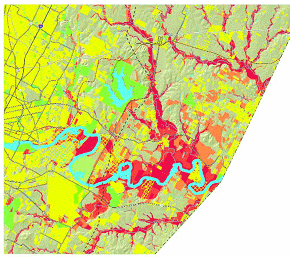
This map shows the Travis County, TX Greenprint and the overall conservation priorities. Areas in orange have a moderate conservation priority and areas in dark red have a high conservation priority.
Source: Trust for Public Land
Because Greenprinting identifies areas that offer the highest conservation benefit, the process has helped CAPCOG galvanize public support and encourage partners to work towards common goals. It has offered the region the ability to create a forward-thinking vision for growth that puts community values first. This is an important accomplishment in a region where landowners have sometimes viewed mapping as a virtual taking of property. CAPCOG is working to make the Greenprinting process less threatening by demonstrating that it simply another tool to streamline the project development process.
The value of the Greenprint has been recently illustrated. A 49-mile highway bypass of Austin-State Highway 130-had begun construction just prior to the Greenprinting process. At the time of construction, not all conservation priorities and values had been taken into account in the way that having a Greenprint would allow. Once the Greenprint was complete, CAPCOG overlaid the SH130 corridor with the conservation priorities the Greenprint identified. It became apparent that portions of the new highway were very close to high priority areas. Had the Greenprint information been available earlier, the highway might have been built on a slightly different alignment, avoiding more of the important resource areas.
In the next six months, the project team will finalize the model that will help identify priority areas for preservation in the Central Texas region. CAPCOG also expects a draft report on the Central Greenprint for Growth to be completed in October 2009. The draft report will be distributed along with an interactive internet-based map of the conservation priorities. It is anticipated that outputs from the Greenprinting process will be integrated into to the long-term transportation planning process in neighboring regions.
Comments, Questions, and Answers
Comment: The real-time voting process that CAPCOG used during the public involvement process for the Greenprint was the first time CAPGOG had experienced the simultaneous synthesis of GIS and other technologies, public interaction, and consideration of ecological resources. Ground that would have normally taken several months to cover was covered in a few hours.
Houston-Galveston Area Council (H-GAC)
Meredith Dang and Amy Boyers
H-GAC is the MPO and COG for an eight-county region, centered on Houston. Most of the region is has a low-density development pattern, but projected population growth might require new considerations for growth management and planning. Presently, there are approximately 5.5 million people living in the H-GAC region. It is estimated that an additional 3.5 million people will move to the region in the near future. H-GAC aims to be leader in shaping regional growth, balancing the expected population boom with protection of the region's natural resources.
FHWA awarded an Eco-Logical grant to H-GAC to develop a GIS-based environmental resource identification map to assess critical conservation areas, integrate resource and conservation planning through a regional decision support system, and identify high-priority mitigation locations. The regional decision support system would establish an evaluation system for transportation projects, providing transportation planning agencies the ability to assess the impact of specific transportation projects on critical environmental areas. The effort represents southeastern Texas' first regional, systematic identification of critical environmental resources at the scale necessary for transportation and conservation planning.
The 2006 H-GAC long range transportation plan (LRTP) was the first time that the region attempted to link conservation to the transportation planning process. The effort began when H-GAC convened a large group of stakeholders, some of whom would later form an Environmental Advisory Committee (EAC), for a charrette. With the results from the charette, H-GAC created a map of regional priorities, which demonstrated that uncontrolled growth in the region could significantly degrade many of its most important environmental resources. Although the map helped inform the public and resource agencies, it was static and could not be easily updated or manipulated online.
The EAC decided that a GIS-based tool would enable H-GAC to expand its capabilities to identify priority conservation areas in its current LRTP plan update. To do so, the EAC first defined the region's ecotypes. Through deliberation, nine ecotypes were identified, including one that the public suggested that includes local plant species and historic resources. H-GAC also asked the EAC to determine eco-logical services in the region by using defensible, weighting metrics based on the intrinsic value of the ecotype. Although EAC members each have his/her own views of the priorities, the EAC begins each meeting by stating that the goal of the effort focuses not just on individual resources at the parcel level, but on regional outcomes.
One of H-GAC's primary data resources was EPA's GISST tool, which is a GIS-driven environmental assessment and data management tool for environmental streamlining that is shared with Texas DOT. GISST uses ArcGIS to identify and map environmental concerns and to screen potential projects. It uses over 100 different types of environmental resource criteria. H-GAC has also worked with the Texas Coast Watershed Program to map the ecotypes using aerial photography and soil surveys. With these and other related data, H-GAC has started to rank the region's areas of ecologically importance by using "weighted maps" (based on size, shape, and scarcity) to determine relative importance. In some cases, smaller wetland areas only seemed important after the weighting. Because H-GAC did not want to penalize these wetlands based on their size, H-GAC decided to compare importance within ecotypes instead of across ecotypes.
These and other findings from using the GIS tool are expected to be incorporated into the 2010 update to the regional transportation plan (RTP). After the RTP is adopted, H-GAC plans to begin work with Harte Research Institute researching the economic value of the region's environmental resources. Ultimately, H-GAC intends to make its mapping and ecotype weighting tool available to the public and hopes that the public become more involved in the prioritization and planning process.
North Central Texas Council of Governments (NCTCOG)
Tamara Hollowell and Sam Brush
NCTCOG was established to assist local governments in planning for common needs, cooperating for mutual benefit, and coordinating for sound regional development. The MPO serves a nine county, 5000 square mile, region of North Central Texas, which is centered on the two urban centers of Dallas and Fort Worth. NCTCOG has over 230 member governments including 16 counties, numerous cities, school districts, and special districts.
As part of its Eco-Logical project, NCTCOG plans to develop a regional ecosystem framework (REF) that integrates environmental and infrastructure plans across agency and geographical boundaries, an activity complementing others previously underway at the MPO. The effort, which also aligns with new requirements for consultation and mitigation strategy consideration in SAFETEA-LU Section 6001, focuses on developing strategies that encourage planners to consider environmental impacts and mitigation during the LRTP process. NCTCOG anticipates the REF will enable the agency to merge green and grey infrastructure concepts, while allowing for an increased focus on stewardship, a better understanding of different resource agencies' concerns, and potentially a regional, as opposed to a project-by-project, approach to mitigation.
To begin creating the REF, the project team collected approximately 200 data sets. NCTCOG then selected one transit and two roadway projects as pilot corridors to explore what level of geography seemed to be most sensible for applying the REF. In August 2008, NCTCOG used EPA's NEPA Assist Tool to identify the corridors' respective environmental constraints, especially watersheds.
NCTCOG has found that by working on a watershed basis (based on new Natural Resources Conservation Service watershed and sub-watershed delineations) has taken away some of the strife that can exist when solely political boundaries are used to differentiate regions. This is due in part to the priority given to drinking water in Texas; NCTCOG's 2007-2011 strategic plan has an objective that aims to provide North Texans safe waterways with clean water within an REF of green watersheds by 2025. It is also because NCTCOG has found that a 15-75 sq-mi size range seems appropriate for analyzing the interaction of transportation and natural resources at the sub-watershed level. In the past, scale issues have been challenging for NCTCOG to overcome. For example, NCTCOG's transportation projects have not always been compatible with the sub-basin, watershed, or sub-watershed scales typically used for making environmental considerations. Furthermore, NCTCOG is developing an assessment of the ecosystem's health in the pilot corridor sub-watersheds as a basis for determining cumulative effects associated with the planned transportation infrastructure. Through developing the REF, NCTCOG is developing a way to reconcile these differences and find the overlap among the on-going conservation efforts of stakeholders in the region.
The process has been underway for approximately a year, and it is estimated that it will be another 18 months before the REF is complete. Over the next year, NCTCOG will meet with resource agencies to figure out how to incorporate the sub-watershed analyses, including the identification of primary conservation areas, into Mobility 2035, the metropolitan transportation plan for the Dallas-Fort Worth area, to be completed in the fall 2010.
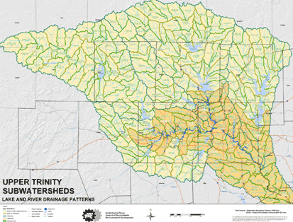
This map shows the lake and river drainage patterns of the Upper Trinity Sub-watersheds, Texas.
Source: NCTCOG
U.S. Environmental Protection Agency (EPA) Region 6
Sharon Osowski
EPA Region 6 is headquartered in Dallas, Texas and encompasses a five-state region that includes Arkansas, Louisiana, New Mexico, Oklahoma, and Texas, as well as 65 Tribes. FHWA selected EPA Region 6 to receive an Eco-Logical grant to enhance and extend the Texas Ecological Assessment Protocol (TEAP), a planning and screening level assessment tool that uses existing GIS data to classify land based on ecological importance. The TEAP methodology consists of collecting and analyzing existing electronic data available statewide to evaluate the following three ecological criteria:
- Diversity (habitats and landscape): What areas have the most diverse land cover?
- Rarity (threatened and endangered species): What areas have the highest number of rare species and land cover types?
- Sustainability (human impacts such as stressors and fragmentation): What areas can sustain ecosystems now and in the future?
The protocol uses these components to identify areas of key ecological importance by combining data layers and creating a composite that depicts the top one percent of importance through these layers.
In the past, TEAP was used to analyze 18 ecoregions in Texas. Using its Eco-Logical grant, EPA Region 6 is now working to expand the protocol to 38 ecoregions to create the Regional Ecological Assessment Protocol (REAP), which will cover Arkansas, Louisiana, New Mexico, Oklahoma, and Texas. EPA chose to use ecoregions as the unit of measurement in the REAP because they allow calculations to be made within watersheds, which become indicators of regional areas of sustainability and diversity. Through applying REAP, EPA and its partner agencies hope to counteract fragmentation and identify mitigation opportunities. Because the tool can show areas of rarity and opportunity from a regional perspective, it can also easily show transportation corridors and urban areas. REAP's outputs will become inputs GISST, another GIS-based tool of EPA's that uses scoring to assess environmental impacts, thus allowing planners to identify alternatives that avoid environmentally critical areas.
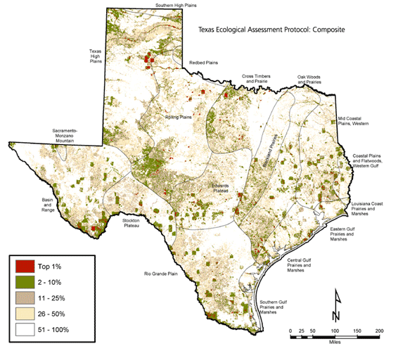
Texas Ecological Assessment Protocol Composite Map
Potential uses for REAP include supporting the LRTP process and shorter-term planning for complex projects and mitigation, conducting NEPA analysis and assessment-especially during the scoping phase, and meeting SAFETEA-LU consultation requirements.
Comments, Questions, and Answers
- Question: Have there been any estimates as to how much TEAP/REAP might streamline the NEPA process?
Answer: An EPA Region 6 study showed that roughly 18 months could be saved in the scoping process if TEAP/REAP was used. Once the DEIS is released, any streamlining benefits likely end.
Comment: One initial of the results of CAPCOG's Greenprint is that certain areas scored very highly; one county, in particular, appeared to have very important environmental resources. CAPCOG was glad to see find that its findings seem consistent with EPA Region 6's TEAP findings. When important ecological areas are matching up across agencies' separate analysis, then it is likely that those areas are very significant. - Question: When does the EPA grant end, and when will the new data be available?
Answer: The grant ends in January 2011. However, some of the data will likely be released in 2010.
Comment: FHWA has built flexibility into the grant process. If agencies foresee challenges in meeting previously established deadlines, they should coordinate as early as possible with their FHWA technical contact to determine how challenges can be resolved.
Mid-America Regional Council (MARC)
Tom Gerend and Tom Jacobs
MARC is a nonprofit association of city and county governments and the MPO for the bistate Kansas City region. MARC serves 9 counties, which include 120 separate city governments and approximately 1.9 million people. The region, which has no natural constraints or barriers to growth, is expected to expand by 500,000 people by 2040.
MARC was awarded an Eco-Logical grant to conduct a series of workshops to begin an effort to foster stronger interagency relationships and an understanding of Eco-Logical approaches in the Kansas City metro region. The workshops were expected to lead to longer-term collaboration in the environmental, transportation planning, and consultation processes, ultimately resulting in the development of a regional, ecosystem-based infrastructure mitigation strategy. Participants at the workshops included staff from a variety of Federal, State, local and tribal agencies, as well as private consultants, from both Kansas and Missouri.
As a result of the workshops, MARC has created a draft action plan and established a project advisory committee to help the MPO better link environmental and transportation planning. The draft action plan's aim is to align decision-making and funding with the region's vision for growth. For example, building on a regional conservation plan developed several years ago, MARC's Eco-logical project has helped set a strong foundation for how MARC incorporates environmental issues into the LRTP process at the earliest stages. From 2005-2006, MARC created a regional natural resource inventory to describe the natural resources in the Kansas City region. Characteristics like natural resource quality, distribution, and extent were displayed in "MetroGreen," a tool that mapped conservation value and threats. MetroGreen, which now identities more than 75 separate corridors that will form a regional network to connect many of the area's most valuable natural assets, outlined factors that might affect conservation priority areas.
During the first few months of the process to update the LRTP, MARC was developing a policy framework that articulated the role of transportation in supporting the region's vision for growth. At this time, the MetroGreen map was overlaid with the Transportation Improvement Program (TIP) to determine the relationships between proposed transportation projects and natural resources. GIS was used to tie together demographic, land use, transportation, and environmental data. MARC wanted to help policy makers understand the implications of various LRTP goals scenarios. MARC also wanted to have a better grasp of the conditions for which local communities were planning. To do so, "Paint the Town," a customized software program that allows planners and forecasters to "paint" maps on a computer screen to simulate existing and future land-use patterns, was used. The maps created included detailed information about things like population density, sewer and water lines, and natural resources. Paint the Town also incorporates local governments' comprehensive plans to indicate probable future uses of undeveloped land to the parcel level.
The final result was a growth probability map. The map will be used as a baseline against which alternative "what if" growth scenarios will be compared. MARC hopes to answer questions like, "What would happen to travel behavior if carbon dioxide becomes considered a pollutant?" or "What if explosive growth actually happens in the region?" In the fall 2009, MARC expects to discuss what growth assumptions it will make: business-as-usual assumptions or assumptions based on what the maps illustrate.
MARC's Lessons Learned
- Internal and external organizational barriers need to be evaluated. First, the MARC project team learned that some State resource agencies were reluctant to commit staff to this effort and expressed concerns that participation may be intimidating to stakeholders who have not traditionally been part of the transportation planning process. It has become apparent that interdisciplinary collaboration is an essential precondition for accomplishing expected outcomes.
Internally, MARC identified structural impediments to implementing Eco-Logical. With the integration of technical information often an emphasis, MARC identified a need to develop an organizational, committee structure that allowed it to make on-going environmental considerations-not only when transportation projects came along. MARC decided a process mechanism for disseminating environmental information and strategies to decision-makers was necessary to enable it to devise policies, plans, and management strategies to protect the environmental priority areas. - Data is only important as far as it supports decision-making. MARC anticipates using the plans it develops to make proactive decisions, especially regarding regional mitigation strategies. The agency believes there are opportunities for strategically leveraging mitigation dollars to create the best natural resource benefit possible.
Comments, Questions, and Answers
Question: What is the composition of MARC's advisory board?
Answer: MARC's Board of Directors, which consists of 33 locally elected leaders from the 9 member counties and the 6 largest cities in the region, is the final point of decision for the agency, but many committees and subcommittees advise the board. The Total Transportation Policy Committee advises the MPO Board of Directors on Transportation Issues and is the policy board for the MPO.
Comment: Communities have a choice as to what they will look like in the future. The value of what MARC has done seems to be showing how changes in assumptions about future growth can dramatically alter a region's vision. Having an accurate portrayal of growth can be very powerful in helping determine a sustainable path that is aligned with stated goals.
Tri-County Regional Planning Commission (TCRPC) Eric Miller and Terry Kohlbliss
Established in 1958, the TCRPC serves the Tri-County Region in Central Illinois, including Peoria, Tazewell, and Woodford Counties. TCRPC conducts metropolitan transportation planning in an effort to promote responsible land use management and protection of the environmental assets in the region. The region has 350,000 residents, 112,000 of whom live in Peoria. Over the past several years, Peoria's population has slightly declined, while areas elsewhere in the region have grown.
Historically, there has been a "build anything, anywhere" mentality among many in the region. Over recent years, TCRPC has emphasized the importance of comprehensive and coordinated planning. Some in the Tri-County region fear that the region will revert to viewing heavy building as a panacea to current economic volatility (i.e., increased construction would lead to new jobs, stimulating the economy), ultimately leading to significant environmental damage. For this reason, TCRPC's Eco-Logical grant project aims to combine various State, local, and non-governmental organization's plans to best integrate transportation, ecosystem considerations, and land use planning throughout the region. The plan will serve as a comprehensive, integrated guide for development and conservation that establishes and prioritizes opportunities for improvement. The plan will assist the region's units of government and the private sector in shaping the development landscape over the coming decades.
At TCRPC, the Eco-Logical project is known as "the big plan," and focuses on transportation, public infrastructure, and determining the location of and motivation for building roads, water, and other community assets. In the Tri-County region, there is little congestion. The primary transportation issue facing the Tri-County region is that there is a lack of alternatives to vehicles and no direct highway to Chicago. In the near future, expansion of the regional roadways will be necessary, and "the big plan" is expected to help the area expand in an environmentally sensitive way.
In terms of GIS, TCRPC is the principal coordinator for a regionally compatible geospatial dataset for the Tri-County area. Most of the data in this system was developed at the local level by multiple government units and was funded through the Illinois Department of Transportation's allotment of Federal State Planning and Research Grants and an innnovative county recording fee that charges $3-$13 per deed recorded. TCRPC houses the GIS software and hardware, but any community can upload their GIS data to the web-based system. Through analyses of these local data, TCRPC has been able to run various scenario planning models and to develop a series of environmental and transportation plans, such as a ravine protection plan and a freight logistics site inventory that identified critical sites along a river.
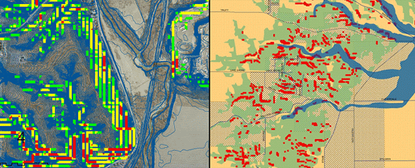
Images from TCRPC's Ravine Protection Plan
Comments, Questions, and Answers
Question: How has TCRPC engaged stakeholders?
Answer: In TCRPC's most rural county, the board passed a resolution to create a comprehensive plan for the county. Stakeholders voiced a desire to extend corridor plans out to the next population area. Presently the project is in the information gathering process. The technology has given TCRPC the opportunity to obtain a greater amount and more meaningful public input. TCRPC has had nine million hits on its GIS site since the site's inception.
Oregon State University (OSU)
Jimmy Kagan and Esther Lev
Before Eco-Logical was published, The Wetlands Conservancy had been working to determine how to best use limited funding for wetland protection. The organization wanted to better understand what wetlands had been lost and how to prioritize which wetlands should be the focus of protection first. The question The Wetlands Conservancy posed was: if there are going to be impacts to wetlands, then why not have agencies mitigate in the areas known to be most productive and/or where the most significant resource improvement could be made? It was determined that a one-stop, portal where geospatial data on all conservation resources would be stored was needed. The identified need mobilized a number of state agencies in Oregon, including OSU.
OSU's Eco-Logical grant project, which builds on Oregon's Conservation Strategy (OCS) completed approximately seven years ago, aims to create a single source of information to help conserve ecologically significant habitats and simplify the permitting process for development or mitigation. The project will move existing information on wetlands, endangered species, habitats and important natural resources from the coarser landscape plane to a more detailed project-level and offer this information in a publicly-accessible online system. The system can then be used to integrate conservation concepts into Oregon DOT's planning process and regulatory agencies' conservation and mitigation decision-making.
The project is being implemented in three phases:
- Compile and integrate comprehensive project-level conservation data from the Willamette Basin as a pilot
- Compile and integrate current wetland, threatened and endangered species, and conservation strategy data for Rogue and Deschutes Basins
- Inventory all existing data layers and prioritizations and develop a roadmap on how to reach a finer level of detail of prioritizations and site specific strategies and goals
In the first phase, OSU and The Wetlands Conservancy worked to determine wetlands and avoidance/mitigation priorities for Oregon's Willamette Basin. OSU and The Wetlands Conservancy had to first determine how to synthesize the mass of available data. A problem encountered from the earliest stages is one that most other places (in the country or even in other regions in Oregon) likely do not have: an excess of conservation strategies. Over recent years, a number of complex conservation strategies have been developed for the Willamette Valley. In addition, Oregon DOT has its own statewide wetlands mapping system that was independent from all other wetland mapping activities in the State.
To overcome this obstacle, a consortium led by The Nature Conservancy, and including OSU, the Oregon Department of Fish and Wildlife, Oregon Parks and Recreation Department, and a number of other partners, combined features from five Willamette Basin conservation assessments into a "Union Portfolio." The portfolio was intended to allow OSU the ability to find synergistic points between the datasets. OSU also investigated general land surveyors' notes and photos from as early as 1881 that described what the land looked like when settlers first arrived. Maps from the Oregon Historical Society were used to create a diorama and a helicopter flyover movie of the wetlands data to show how conditions have changed over time. Boundaries for wetland sites in the portfolio were refined using 2005 imagery and GIS data for rare species, vegetation, land management, land use, and zoning. The idea was to make broad scale estimates so that smaller-level analyses could be done more quickly
.In the second phase, OSU took known species occurrence data to create inductive models that predict where threatened and endangered likely are, to describe which variables are most important in determining species location, and to explain how confident the model is in its predictions. These models are publicly available, potentially alleviating the concern that some agencies in Oregon have expressed about making endangered species occurrence location data more broadly available. The problem regulators have seen is that the existing data describe only where species are but do not indicate where they are not. These models describe where the species are likely to be.
Comments, Questions, and Answers
Question: How were differences between wetlands delineations on the maps reconciled and were the wetlands data included in the National Wetland Inventory (NWI) manually digitized?
Answer: Differences were resolved manually. Graduate students manually updated the polygons where necessary. Regarding the NWI wetlands data, a $150,000 grant to have graduate students and the Oregon prisons digitize all of the scanned maps was received.
Question: Is OSU's predictive modeling process the same as NatureServe's?
Answer: The modeling process is not the same. However, NatureServe is a partner, and the best approach is still being determined.
Question: Has the predictive model been used yet when there is an actual transportation project, and if so, have resource agencies agreed with its use?
Answer: The model has been applied locally in Oregon and in Florida. Resource agencies have generally bought in with the model. In instances where they have not, model results have been misinterpreted. For example, when the model predicts locations for endangered species, it is not indicating that all other locations are those where the endangered species are not found.
Question: Could OSU's approach be applied to other areas? Can the model help quantify the benefits of ecosystem services?
Answer: In Oregon, there has been an effort to try and measure the value of services that clean water provides. Research is on-going to define where wetlands are critically linked and how functional they will be, characteristics which are linked to services yielded. The biggest variables with these predictive models have been the variables regarding climate. However, OSU estimates it could make a similar model available for the entire country for approximately $10M.
Question: Has Portland's MPO taken most of the region's wetland acres?
Answer: The MPO has not impacted a majority of the region's resources. Some have even noted that transportation planning has been one of the more effective vehicles for ecological planning in the Portland metro region.
Audubon Society of New Hampshire
Carol Foss and Vanessa Jones
Founded in 1914, the New Hampshire Audubon (NHA) is a nonprofit membership organization that focuses on wildlife and habitat conservation throughout New Hampshire. The State comprises 10 counties and 9 regional planning commissions, but planning is typically done locally by each of over 200 municipalities. Towns can elect to be part of a regional planning commission, or they can decide to plan independently. As a result of the dispersed authority, it can be difficult to accomplish planning at a statewide level in New Hampshire.
Through its Eco-Logical project NHA aims to provide the data and tools necessary to support the coordination of transportation and resource planning in New Hampshire with the goal of improving the environmental outcomes of transportation projects. The project will develop an impact assessment framework to identify conflict areas at an ecosystem scale. The final data products and planning framework are together expected to serve as a model for other regions that, like New Hampshire, do not have widely distributed habitat or a clearly defined ecosystem that supports one or more rare species.
To foster existing relationships and develop the new relationships necessary to develop the framework, NHA established the "Eco-Logical Project Partnership Work Group" (Work Group). The Work Group is made up of representatives from Federal and State agencies, NGOs, one regional planning organization, and one consultant. Together this group has worked to conduct outreach on the effort and to identify major conservation data gaps.
To address some of the data gaps, NHA partnered with the New Hampshire Fish and Game Department to create the New Hampshire Wildlife Connectivity Model. The model ranks the biological, landscape and human impact factors most affecting each habitat type in the State. With data from the model and a variety of other sources, including the State's GIS clearinghouse GRANIT,3 NHA used ArcGIS' Corridor Designer tool to identify and evaluate corridors between fragmented habitat blocks. Specifically, NHA examined how wildlife best move through habitat by accounting for and weighting factors, such as land cover, distance to roads, riparian areas, and slope.
NHA also developed data sheets for all of the species evaluated and outlined a scoring system for each. Then, NHA developed a least-cost surface for each of the species, with "high cost" areas being those through which species have difficulty moving. After GPS-validating the least-cost model for 16 species, NHA created corridors using existing conservation land to understand the connectivity opportunities between existing and modeled habitat locations.
As a next step, NHA plans to continue connecting with groups throughout the State to determine where and how the Wildlife Connectivity Model might be best integrated into transportation planning processes. There are also ongoing discussions about creating a publicly-accessible, online registry of conservation plans, open space plans, and related datasets.
Questions, Comments, Answers
Question: Were wildlife-vehicle collision data used in creating the least-cost model?
Answer: Wildlife-collision data that show where wildlife crossings were not successful were used. New Hampshire State Police have GPS data and record moose and deer strike.
Question: How much interaction with resource agencies did you have to develop the species list and the data behind it?
Answer: NHA mostly worked with the New Hampshire Fish and Game Department and the University of New Hampshire. The habitat information was based on literature and the expertise of the biologists in the region.
Question: Has NHA considered using another name for the "least-cost corridors?"
Answer: NHA has considered changing the name. "Connectivity zone" might be a good alternative.
IV. ROUNDTABLE DISCUSSION AND OBSERVATIONS
To conclude the peer exchange, participants had an informal conversation about the specific presentations made on Day 1, as well as related topics of interest. Due to the impromptu nature of the discussion, common observations, challenges, and lessons learned have been broadly organized into the following categories and are discussed in more detail below:
- Data sharing and collaboration
- Consistency in terminology and approaches
- Balancing Eco-Logical principles with the need to implement projects quickly
- Integration of transportation and environmental considerations in planning
Data sharing and collaboration. In many cases, MPOs have developed or acquired the data resources needed, while the State agencies are still developing theirs. With so many groups seemingly working on data issues nationwide, there appears to be an opportunity for capitalizing on economies of scale. The future seems to balance on the data collection and management approach taken. Additionally, the lack of standards for land cover data can make it difficult to reconcile differences between several councils of governments in an area.
In New Hampshire, the State Office of Energy organizes a GIS Advisory Committee. The committee convenes quarterly to discuss current data needs and what various activities are underway. Agencies on the committee have decided that if two or three agencies will be using data, then each agency should contribute funding to a data coordination effort. Similarly, approximately five years ago, MARC received a number of requests from counties and municipalities to start their own GIS. MARC initiated a program that would give these entities $80,000 to support aerial photography acquisition, data-sharing agreements, and other geospatial activities that they had not previously conducted. However, a challenge has been Federal agencies' occasional reluctance to sign MARC's data sharing agreement. Those who buy MARC's data, such as consultants, might believe that they were being treated unfairly if the Federal agencies received the data for free and then redistributed it.
Consistency in terminology and approaches. Peer exchange participants identified a need to standardize terms, such as "ecotype" or "habitat," among agencies. It is also important that agencies' respective GIS tools be integrated, so that all involved will have a generic methodology for mapping and will be analyzing the same data as early as possible.
It would also be helpful if a State's agencies worked together to establish a set of integrated priorities. Given that in most places there are many efforts to identify conservation priorities, having one common vision might be the most efficient way for a State to agree on, develop, and/or apply geospatial data at appropriate and useful scales.
Balancing Eco-Logical principles with the need to implement projects quickly. A significant amount of the ARRA stimulus funding was directed to "shovel ready" transportation projects. The recent push to construct these projects has, in some cases, diverted the focus somewhat from transportation projects that may have been "in the pipeline" for a long time. Although those projects being built as part of the economic stimulus bill are important, there is a need to continue thinking about transportation investments in the broader context, taking into account the multiple benefits that can be achieved by factoring environmental considerations early.
Integration of transportation and environmental considerations in planning. Participants agreed that it is critical to directly tie natural resources considerations into transportation visions and goals. A planning function that integrates both transportation and natural resource staff together can help maximize the comprehensive nature of information upon which policy decisions are made. It can also be bureaucratically easier and more efficient in the long-run. Without integrating the two, it might be more difficult to take a landscape view to how natural resource issues should be approached. In one example, H-GAC's Eco-logical project has been the first time the gap between the MPO's work and environmental resources work has been bridged. Agencies have learned about each others boards, councils, and respective visions. A translation of languages across agency boundaries and concerns has occurred. According to H-GAC, "now that the bridge has been built, the need to keep it open is better understood."
Some have found that making a map of the transportation planning process has facilitated the other stakeholder agencies' involvement. At its first Eco-Logical Workshop, MARC plotted the entire MPO planning process so that the resource agencies could have some context of what transportation planning occurs. The places where all agencies could do things differently and potentially better were then inserted into the map.
Some challenges in integrating environmental and transportation considerations in planning include:
- Determining what metrics to use
- Discussing specific potential impacts of proposed transportation projects in advance of NEPA
- Outreach to other agencies on Eco-Logical and its intent - As much as MPOs have tried to explain the concepts to resource agencies, it has often been the case that resource agency staff have not had the time and resources to dedicate to integrated planning and ecosystem-based mitigation efforts. It was recommended that in planning for the next phase of Eco-Logical, FHWA contemplate ways it could help institutionalize and solidify Eco-Logical more among other agencies.
Appendix A. Participants
Participants
Bethaney Bacher-Gresock
FHWA Office of Project Development and Environmental Review
bethaney.bacher_gresock@dot.gov
Amy Boyers
H-GAC
Amy.Boyers@h-gac.com
Sam Brush
NCTCOG
sbrush@nctcog.org
Sally Campbell
Envision Central Texas
scampbell@envisioncentraltexas.com
Meredith Dang
H-GAC
Meredith.Dang@h-gac.com
Carol Foss
NH Audubon Society
cfoss@nhaudubon.org
David Fowler
CAPCOG
dfowler@capcog.com
Tom Gerend
MARC
tgerend@marc.org
Tamara Hollowell
NCTCOG
thollowell@nctcog.org
Tom Jacobs
MARC
tjacobs@marc.org
Vanessa Jones
NH Audubon Society
vjones@nhaudubon.org
Jimmy Kagan
Oregon State University
Jimmy.Kagan@oregonstate.edu
Terry Kohlbliss
TCRPC
Tkohlbliss@tricountyrpc.org
Esther Lev
The Wetlands Conservancy
estherlev@wetlandsconservancy.org
Diane Miller
Envision Central Texas
dmiller@envisoncentraltexas.org
Eric Miller
TCRPC
emiller@tricountyrpc.org
Sean Moran
CAPCOG
smoran@capcog.com
Lori Olson
Trust for Public Land
Lori.Olson@tpl.org
Sharon Osowski
EPA Region 6
Osowski.Sharon@epa.gov
Carson Poe
U.S. DOT Volpe Center
Carson.Poe@dot.gov
Mark Sarmiento
FHWA Office of Interstate and Border Planning
Mark.Sarmiento@dot.gov
Julianne Schwarzer
U.S. DOT Volpe Center
Julianne.Schwarzer@dot.gov
Appendix B. Agenda
Wednesday, July 22
8:00
Meet in hotel lobby to travel to CAPCOG
Welcome and Background
- Background
Mark Sarmiento, FHWA Headquarters - Overview and Update on Eco-Logical
Jan Brown, FHWA Texas Division Administrator
Bethaney Bacher-Gresock, FHWA Headquarters
Introductions and Overview
- Brief summary of each organization's GIS/Eco-Logical activities
- Needs and challenges
- What would you like to learn?
9:30-11:00
Demonstrations/Presentations, approx. 30-min each
- CAPCOG: Central Texas Greenprint for Growth
- H-GAC
- NCTCOG
Break
11:30-12:30
Demonstrations/Presentations, approx. 30-min each
- USEPA Region 6
- MARC
Lunch
1:45- 2:45
Demonstrations/Presentations, approx. 30-min each
- Tri-County RPC
- OSU
Break
3:00- 3:30
Demonstration/Presentation, approx. 30-min
- Audubon Society of New Hampshire
Thursday, July 23
8:00
Meet in hotel lobby to travel to CAPCOG
Day 1 Re-Cap and Roundtable Discussion
- Filling in data gaps: Approaches to finding missing or hard to locate data
- Standardizing evaluation metrics
- Obtaining stakeholder support for data decision
- Making data accessible to the public
- Interagency component, if applicable
10:15-11:00
Peer Exchange Key Points and Wrap-Up
1Appendix A provides a complete list of participants and attendees.
2https://www.environment.fhwa.dot.gov/env_initiatives/eco-logical/report/eco_index.aspx
3As well as the 2001 New Hampshire Land Cover Assessment, the 2006 National Land Cover Database, U.S. DOT's public roads layer, and traffic data from Maine.